
The Project Gutenberg EBook of Archeological Investigations, by Gerard Fowke

This eBook is for the use of anyone anywhere at no cost and with
almost no restrictions whatsoever.  You may copy it, give it away or
re-use it under the terms of the Project Gutenberg License included
with this eBook or online at www.gutenberg.org


Title: Archeological Investigations
       Bureau of American Ethnology, Bulletin 76

Author: Gerard Fowke

Release Date: July 28, 2006 [EBook #18931]

Language: English

Character set encoding: ISO-8859-1

*** START OF THIS PROJECT GUTENBERG EBOOK ARCHEOLOGICAL INVESTIGATIONS ***


Produced by Robert Connal, Jeannie Howse, Alicia Williams,
Bruce Albrecht and the Online Distributed Proofreading
Team at http://www.pgdp.net (This file was produced from
images generously made available by the Bibliothèque
nationale de France (BnF/Gallica) at http://gallica.bnf.fr)
Transcriber's Note:
Inconsistent hyphenation matches the original document.
Obvious typographical errors have been corrected in this text.
For a complete list, please see the bottom of this document.
For a complete list, please see the bottom of this document.
SMITHSONIAN INSTITUTION
BUREAU OF AMERICAN ETHNOLOGY
BULLETIN 76
ARCHEOLOGICAL INVESTIGATIONS
| I. | CAVE EXPLORATIONS IN THE OZARK REGION OF CENTRAL MISSOURI |
| II. | CAVE EXPLORATIONS IN OTHER STATES |
| III. | EXPLORATIONS ALONG THE MISSOURI RIVER BLUFFS IN KANSAS AND NEBRASKA |
| IV. | ABORIGINAL HOUSE MOUNDS |
| V. | ARCHEOLOGICAL WORK IN HAWAII |
BY
GERARD FOWKE

WASHINGTON
GOVERNMENT PRINTING OFFICE
1922
[3]
LETTER OF TRANSMITTAL
Smithsonian Institution,
Bureau of American Ethnology,
Washington, D.C., February 17, 1920.
Sir: I have the honor to transmit the accompanying manuscript, entitled "Archeological Investigations," by Gerard Fowke, and to recommend its publication, subject to your approval, as a bulletin of this bureau.Bureau of American Ethnology,
Washington, D.C., February 17, 1920.
Very respectfully,
J. Walter Fewkes,
Chief.
Dr. Charles D. Walcott,Chief.
Secretary of the Smithsonian Institution.
[5]
CONTENTS
| I. Cave Explorations in the Ozark Region of Central Missouri | ||
| Page | ||
| Introduction | 13 | |
| The Upper Current River | 18 | |
| Shannon County | 18 | |
| Bat Cave | 18 | |
| Blue Spring, or Fishing Cave | 18 | |
| Welch's Cave | 18 | |
| Big Creek Cave | 18 | |
| Texas County | 19 | |
| Smith Caves | 19 | |
| Saltpeter Cave | 19 | |
| Dent County | 20 | |
| Mammoth Cave | 20 | |
| Guthoerl Cave | 20 | |
| Short Bend Cave | 20 | |
| Money Cave | 21 | |
| Saltpeter Cave | 21 | |
| Watson, Twin, or Onyx Caves | 22 | |
| House mounds | 22 | |
| Phelps County | 22 | |
| Bates Cave | 22 | |
| Another "Bates Cave" | 23 | |
| Renaud Cave | 23 | |
| Marsh Caves | 23 | |
| Wild-hog Cave | 23 | |
| Shelters | 24 | |
| Phelps Cave | 24 | |
| "Key Rocks" | 24 | |
| Jones Cave | 24 | |
| Yancy Mills Cave | 24 | |
| Lane Mound | 24 | |
| Cairns on Lost Hill, at mouth of Gourd Creek | 24 | |
| Exploration of the Gourd Creek Cave | 28 | |
| Onyx Cave | 34 | |
| Goat Bluff Cave | 35 | |
| Cairns at Sugar Tree Camp | 40 | |
| Tick Creek Cave | 41 | |
| Cave in Pool Hollow | 41 | |
| House mounds near Rolla | 41 | |
| House mounds near Dillon | 42 | |
| House mounds near St. James | 42 | |
| [6]Pulaski County | 42 | |
| McWilliams Cave | 42 | |
| Davis Caves | 42 | |
| Berry Cave | 43 | |
| Maxey Cave | 43 | |
| Yoark Cave | 43 | |
| Graves at Laughlin's | 44 | |
| Kerr Cave | 44 | |
| Sell Cave | 45 | |
| Phillips Cave | 51 | |
| Bell's Cave | 51 | |
| Camp-ground Cave | 51 | |
| Bucher Cave | 51 | |
| Graves near McKennan's | 52 | |
| Roubidoux Cave | 52 | |
| Richland Cave | 52 | |
| Rollins Caves | 52 | |
| Mix Cave | 53 | |
| Double Cave | 54 | |
| Railroad Cave | 55 | |
| Bat, or Page, Cave | 55 | |
| Tunnel Cave | 56 | |
| Brooks Cave | 56 | |
| Riddle Cave | 56 | |
| Lane's Cave | 56 | |
| Dry Creek Cave | 56 | |
| House mounds | 56 | |
| Riden's Cave | 57 | |
| Saltpeter Cave | 57 | |
| Miller's Cave | 57 | |
| Ramsey's Cave | 81 | |
| Graham Cave | 83 | |
| Pillman's, or Spring Creek, Cave | 83 | |
| Woodland Hollow Cave | 84 | |
| Walled graves at Devil's Elbow | 84 | |
| Cairns on Helm's farm | 87 | |
| Ash Cave | 89 | |
| Clemmens Creek Cave | 89 | |
| Camden County | 89 | |
| Along the Niangua River | 89 | |
| A fossil cave | 91 | |
| Miller County | 91 | |
| Wright Cave | 92 | |
| Wilson Cave | 94 | |
| Bagnell Cave | 94 | |
| Bode Cave | 94 | |
| Luckenhoff Cave | 94 | |
| Jurggenmeyer Cave | 94 | |
| Daerhoff Cave | 95 | |
| Cave near mouth of Tavern Creek | 95 | |
| Bat Cave | 95 | |
| Grave at mouth of Saline Creek | 95 | |
| Stark's Cave | 96 | |
| House mounds | 96 | |
| Cairns | 96 | |
| [7]Maries County | 96 | |
| Indian Ford Cave | 96 | |
| Lackaye's Bluff Cave | 97 | |
| Hurricane Bluff Cave | 97 | |
| Stratman Cave | 98 | |
| Osage County | 98 | |
| River Cave | 98 | |
| Rock-shelter | 98 | |
| Steuffer Cave | 99 | |
| Cairns | 99 | |
| House mounds | 99 | |
| "Indian Fort" | 99 | |
| Cole County | 100 | |
| Natural Bridge Cave | 100 | |
| Morgan County | 100 | |
| Speers Cave | 100 | |
| House mounds | 100 | |
| II. Cave Explorations in other States | ||
| Introduction | 101 | |
| Indiana | 102 | |
| Lawrence County | 102 | |
| Martin County | 102 | |
| Orange County | 106 | |
| Crawford County | 107 | |
| Harrison County | 111 | |
| Illinois | 111 | |
| Monroe County | 111 | |
| Kentucky | 112 | |
| Hardin County | 112 | |
| Hart County | 112 | |
| Edmonson County | 115 | |
| Warren County | 118 | |
| Barren County | 119 | |
| Monroe County | 120 | |
| Logan County | 122 | |
| Todd County | 122 | |
| Tennessee | 123 | |
| Montgomery County | 123 | |
| Sullivan County | 124 | |
| Bledsoe County | 128 | |
| Sequatchie County | 130 | |
| Grundy County | 131 | |
| Franklin County | 131 | |
| Marion County | 132 | |
| Hamilton County | 133 | |
| Alabama | 133 | |
| Lauderdale County | 133 | |
| Colbert County | 134 | |
| Jackson County | 135 | |
| Dekalb County | 137 | |
| Marshall County | 139 | |
| [8]III. Explorations along the Missouri River Bluffs in Kansas and Nebraska | ||
| Vicinity of White Cloud, Kansas | 151 | |
| Iowa Point | 152 | |
| Near the mouth of the Nemaha River | 152 | |
| Vicinity of Troy, Kansas | 153 | |
| Mouth of Mosquito Creek | 153 | |
| Rulo, Nebraska | 154 | |
| Near Howe, Nebraska | 155 | |
| Peru, Nebraska | 156 | |
| Papillion, Nebraska | 156 | |
| Vicinity of Omaha, Nebraska | 156 | |
| Long's Hill | 157 | |
| IV. Aboriginal Horse Mounds | ||
| New Madrid County | 166 | |
| St. François County | 166 | |
| V. Archaeological Work in Hawaii | ||
| Introduction | 178 | |
| Molokai Island | 179 | |
| The Rain Heiau | 180 | |
| The sacrifice stones | 181 | |
| Hawaii Island | 182 | |
| Kilauea | 183 | |
| Waimea | 183 | |
| Quarry on Mauna Kea | 183 | |
| Kawaihae | 183 | |
| East Point district | 184 | |
| Napoopoo | 184 | |
| Honaunau | 184 | |
| Keauhou | 185 | |
| Mookini | 185 | |
| Laupahoehoe | 187 | |
| Maui Island | 188 | |
| Kaupo, or Mokulau | 188 | |
| Wailuku | 188 | |
| Waihee | 189 | |
| Burial places | 190 | |
| In the Iao Valley | 191 | |
| Kauai Island | 191 | |
| Lihue | 192 | |
| Wailua | 192 | |
| Dune burials | 193 | |
| Waimea | 194 | |
| Conclusions | 194 | |
| Index | 197 | |
[9]
ILLUSTRATIONS
| PLATES | ||
| Page | ||
| 1. | a, Cave on Big Piney River, Pulaski County, Mo. b, Cave on Big Piney River, Texas County, Mo. | 12 |
| 2. | a, Bluff at Mouth of Spring Creek, Pulaski County, Mo. b, Pillman's, or Spring Creek, Cave, Pulaski County, Mo. | 12 |
| 3. | Map of area examined | 18 |
| 4. | Bone and antler implements from Gourd Creek Cave, Phelps County, Mo. | 34 |
| 5. | Shell and flint objects from Gourd Creek Cave | 34 |
| 6. | Skull from Goat Bluff Cave, Phelps County, Mo. | 38 |
| 7. | Skull from Goat Bluff Cave | 38 |
| 8. | Skull from Goat Bluff Cave | 38 |
| 9. | Skull of child from Goat Bluff Cave | 38 |
| 10. | Flints from Goat Bluff Cave | 38 |
| 11. | Bone and antler implements from Goat Bluff Cave | 38 |
| 12. | Bone and antler implements from Goat Bluff Cave | 38 |
| 13. | a, Cairn 6 miles north of Arlington, Mo. b, Walled grave 6 miles north of Arlington, Mo. | 38 |
| 14. | Cairns on Roubidoux Creek, 6 miles from Waynesville, Mo. | 46 |
| 15. | Flints from Sell Cave, near Waynesville, Mo. | 46 |
| 16. | Objects from Sell Cave. a, Pestles or grinding stones; b, celt, pottery disks, paint stones, and skiver | 46 |
| 17. | Three skulls from Pulaski County, Mo. a, b, Skull from Sell Cave; c, d, skull from Bell's Cave, near Waynesville; e, f, skull from Miller's Cave | 46 |
| 18. | Teeth from Sell Cave and other caves, showing manner and amount of wear | 48 |
| 19. | Teeth from Sell Cave and other caves, showing manner and amount of wear | 48 |
| 20. | a, b, Skull from Miller's Cave, Pulaski County, Mo.; c, part of skull of child from Miller's Cave | 68 |
| 21. | Skull of young woman from Miller's Cave | 68 |
| 22. | Skull of child from Miller's Cave | 72 |
| 23. | Diseased tibia of adult and diseased bones of child from Miller's Cave | 72 |
| 24. | Skull of child from Miller's Cave | 72 |
| 25. | Cache of flints from ash bed in Miller's Cave | 72 |
| 26. | Flints from Miller's Cave | 76 |
| 27. | Flints from Miller's Cave | 76 |
| 28. | Flints from Miller's Cave | 76 |
| 29. | Axes and pestles from Miller's Cave | 76 |
| 30. | Bone implements from Miller's Cave | 78 |
| 31. | Bone implements from Miller's Cave | 78 |
| [10]32. | Bone implements from Miller's Cave | 78 |
| 33. | Bone implements from Miller's Cave | 78 |
| 34. | Bone and antler implements from Miller's Cave | 78 |
| 35. | Antler implements from Miller's Cave | 78 |
| 36. | Skivers, showing stages of manufacture, from Miller's Cave | 78 |
| 37. | Shell spoons, pottery disks, and broken spoon made of a deer's skull, from Miller's Cave | 78 |
| 38. | a, Heiaus A and B, on Molokai Island, looking west; b, Heiau A, on Molokai Island, looking north; c, Heiaus A and B, on Molokai Island, looking south | 180 |
| 39. | a, Heiau A, on Molokai Island, looking south; b, platform in Heiau A, looking southeast; c, paved way in Heiau A, looking southwest | 180 |
| 40. | a, Paved way in Heiau A, looking north; b, fireplace in Heiau A | 180 |
| 41. | a, Heiau B, on Molokai Island, looking northwest; b, Heiau B, showing stone-paved interior, looking northeast | 180 |
| 42. | a, The "Rain Heiau," Molokai Island, looking west; b, The "Rain Heiau," looking south | 180 |
| 43. | a, The "Rain Heiau," looking north; b, The "Rain Heiau," looking southwest | 180 |
| 44. | a, The "Sacrifice Stones," on Molokai Island, looking southwest; b, The "Sacrifice Stones," looking west | 180 |
| 45. | a, The "Sacrifice Stones," looking northwest; b, the "Sacrifice Stones," looking south | 180 |
| TEXT FIGURES | ||
| 1. | Outline of Cairn (1), at Lost Hill, Phelps County, Mo. | 26 |
| 2. | Outline of Cairn (2), at Lost Hill, Phelps County, Mo. | 26 |
| 3. | Pipe from Cairn (2) | 27 |
| 4. | Outline of Cairn (3), Lost Hill | 28 |
| 5. | Fragment of glass bottle from Goat Bluff Cave | 37 |
| 6. | Pot from Goat Bluff Cave | 39 |
| 7. | Grooved ax from Goat Bluff Cave | 40 |
| 8. | Perforated object of antler from Sell Cave | 48 |
| 9. | Rubbing or polishing stone from Sell Cave | 48 |
| 10. | Flints from Sell Cave | 49 |
| 11. | Incised figure in sandstone near Miller's Cave | 61 |
| 12. | Incised figures in sandstone near Miller's Cave | 61 |
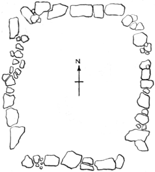
| 13. | Plan of Miller's Cave | 62 |
| 14. | Clay pipe from Miller's Cave | 69 |
| 15. | Perforated bone object from Miller's Cave | 79 |
| 16. | Adz or gouge of chert from Miller's Cave | 79 |
| 17. | Clay pipe from Miller's Cave | 80 |
| 18. | Columella bead from Cairn (4), Devil's Elbow | 87 |
| 19. | Columella bead from Cairn (5), Devil's Elbow | 87 |
| 20. | Plan of Fossil Cave | 92 |
| 21. | Section of Fossil Cave | 92 |
| 22. | Perforator and knife from Wright Cave | 93 |
| 23. | Cross section of Fort Deposit Cave at 18 feet | 144 |
| 24. | Cross section of Fort Deposit Cave at 20 feet | 144 |
| 25. | Cross section of Fort Deposit Cave at 22 feet | 144 |
| 26. | Cross section of Fort Deposit Cave at 26 feet | 145 |
| 27. | Cross section of Fort Deposit Cave at 28 feet | 145 |
| [11]28. | Cross section of Fort Deposit Cave at 30 feet | 145 |
| 29. | Cross section of Fort Deposit Cave at 35½ feet | 146 |
| 30. | Cross section of Fort Deposit Cave at 47½ feet | 146 |
| 31. | Cross section of Fort Deposit Cave at 60 feet | 146 |
| 32. | Cross section of Fort Deposit Cave at 70 feet | 147 |
| 33. | Cross section of Fort Deposit Cave at 90 feet | 147 |
| 34. | Cross section of Fort Deposit Cave at 93 feet | 148 |
| 35. | Cross section of Fort Deposit Cave at 175 feet | 149 |
| 36. | Cross section of Fort Deposit Cave at 180 feet | 149 |
| 37. | Plan of House Mound in St. François County, Mo. | 168 |
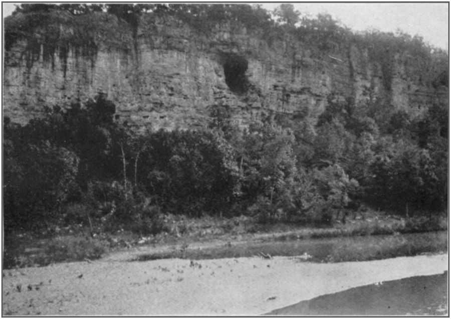
PLATE 1 a, Cave on Big Piney River, three miles east of Big Piney, Pulaski County. Mo.
(Courtesy of Dr. P.J. Heuer, St. Louis)ToList
(Courtesy of Dr. P.J. Heuer, St. Louis)ToList
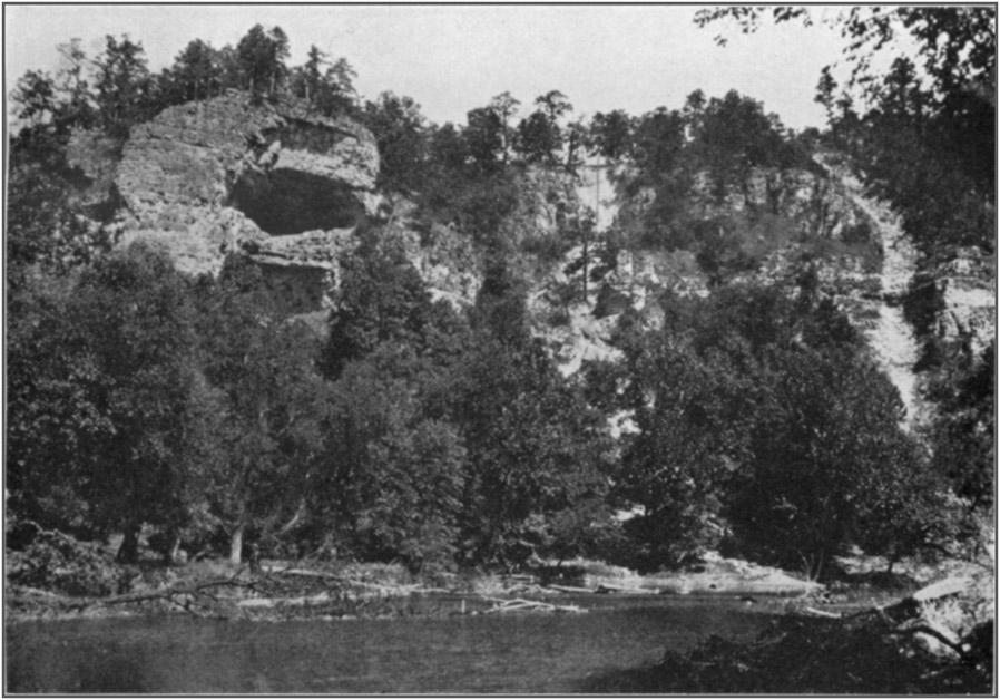
PLATE 1 b, Cave on Big Piney River, in Texas County, Mo.
(Courtesy of Dr. P.J. Heuer, St. Louis)ToList
(Courtesy of Dr. P.J. Heuer, St. Louis)ToList
PLATE 2 a, Bluff at mouth of Spring Creek, Pulaski County, Mo.
(Courtesy of Dr. P.J. Heuer, St. Louis)ToList
(Courtesy of Dr. P.J. Heuer, St. Louis)ToList
PLATE 2 b, Pillman's, or Spring Creek, Cave, Pulaski County, Mo.
(Courtesy of Dr. P.J. Heuer, St. Louis)ToList
(Courtesy of Dr. P.J. Heuer, St. Louis)ToList
[13]
ARCHEOLOGICAL INVESTIGATIONS
I. EXPLORATIONS IN THE OZARK REGION OF CENTRAL MISSOURIToC
By Gerard Fowke
INTRODUCTION
The geological structure of that portion of southern Missouri which lies to the westward of the Archean rocks near the Mississippi River is peculiarly suitable for the development of caverns. The Ozark uplift produced far-reaching undulations, and there seem to have been no violent disturbances which would result in extensive faults, considerable displacements, or a pronounced inclination of the strata. Jointing and pressure cleavage, however, gave rise to innumerable crevices in the limestone, through which percolating surface water found its way into all parts of the formations. By its solvent power this water gradually enlarged the crevices into passages which, multiplying and uniting, drained constantly increasing areas until they formed subterranean streams with a perpetual flow. Thus began caverns; and these grew in depth, width, and height as the rock was eroded and dissolved. Tributary crevices were subject to the same action; and there was finally created by each of these water systems a network of cavities whose ramifications sometimes extend throughout several townships. In time, sections of the roof, here and there, became so thin from the combined erosion taking place both above and below as to be unable to sustain their own weight; the overlying strata fell into the cave, and the volume of water flowing through it was augmented by drainage which had previously been disposed of on the surface. All this had to seek an outlet somewhere, except in those rare instances where it maintains its downward course until, below the level of any open stream it can reach, it encounters an impervious stratum and must lose itself in the deep rocks. Usually, however, it emerges in the face of a bluff or on the side of a hill; and the opening becomes "the mouth of a cave." Occasionally, in such situations, the water continues to flow out; but usually it finds a way to reach a lower level, and so the cave in time [14]becomes dry except for such water as seeps through from the earth immediately above. Sometimes, too, the point of discharge is at or perhaps somewhat below the level of a stream into which it passes; in the Ozarks are numerous very large springs or fountains which by inverted siphon or artesian action are forced up from subterranean streams lying at a greater depth.
Few large caverns have the floor entirely dry, even when they are well above the bottom of the valley. Deposits in the front portion may be dry, perhaps dusty on the surface; but toward the interior moisture usually accumulates until they are muddy or until the water stands in pools or puddles. When this is the case there is sometimes a little stream making its way to the front through a channel which it has cut; or seepage may dampen, possibly saturate, the lowermost portions of the otherwise dry earth. These details are controlled principally by the direction and degree of slopes and by side openings which allow more or less of the water to escape at some part of its journey.
When a cavern is fairly lighted and has a dry floor, whether of rock or earth, it forms an excellent abode for a small community unable or not disposed to construct shelters more comfortable or convenient; and there is abundant evidence that many caves in the Ozarks were utilized as habitations by the aborigines. It must be remembered, however, that in the centuries which have elapsed since hunters or permanent occupants first entered this region, many superficial changes have taken place, not only about the entrances but within the caverns as well. Very probably these alterations have converted caves once occupied into places which at present are quite unfit for such purposes. Talus has accumulated in front of the openings or partially filled the front chambers; it may well be the case that this conceals much refuse. Caves which, from similar deposits, are now difficult to enter and dark to the doorway, may have been open and convenient. Furthermore, caves with wet or muddy bottoms may owe such condition to causes which have recently come into operation; or if they always contained more or less water, the primitive dwellers could in many cases have overcome such disadvantages by digging drains which have since become choked and obliterated. Very small cavities, such as deep rock-shelters; or caverns with a great thickness of earth on the floors, now showing no trace of remains; or those with entrances so small that it is necessary to crawl through—any of these, if cleared out to the bottoms, might disclose material dating back to very early times.
It might seem that the air in a cave constantly occupied would grow stale and close; while smoke from the fires would in time become annoying. But Indians used for fuel only dry wood and bark, the smoke from which would be a negligible factor. The varying [15]pressure of the atmosphere outside creates a current of air in or out which is usually imperceptible but which penetrates to the deepest recesses and insures ventilation.
In view of the very primitive conditions under which cave dwellers lived, as denoted by the artificial objects which they left, and the low mentality indicated by the skulls, Mr. W.H. Holmes suggests that a careful and extended study of these abodes may disclose a culture lower than that prevailing among out-door dwellers in the same localities. As no effort would be required to secure warmth and shelter, and as food was abundant and easily procured, the people may never have advanced from savagery, or may have retrograded.
None of these possibilities are taken into account when reporting upon the caves described in the following pages; the information offered is based entirely upon the present appearance of the places mentioned. To attempt more would be merely offering guesses.
If "Cave Man"—using this term to designate the predecessor of any race or tribe known to history—ever existed in the Mississippi Valley he would not find in any part of it natural features better adapted for his requirements than in the Ozark hills. But, so far, not the slightest trace of his presence has been revealed. Products of human industry have been reported as occurring at great depths under other conditions, even at the bottom of the loess; though in all such cases there is some uncertainty as to the correctness of the observations. No similar reports have been made in regard to any cave yet explored. On the contrary, whatever may be the depth of the deposit containing them, the artificial objects exhumed are uniform in character from top to bottom; the specimens found on the clay or solid rock floor are of the same class as those barely covered by the surface earth. Moreover, when they cease to appear they cease absolutely; the rock was swept bare, or the clay was deposited, by the stream to which the cave owes its existence, and each is a part of the original formation. In these circumstances habitation would be out of the question.
By careful search in the caves and rock-shelters of which the Indian known to history availed himself, extensive and interesting museum collections can be made. To find an earlier man it will be necessary to investigate caverns which he found suitable for occupancy and in which the accumulation of detritus, from whatever source, has been sufficient to cover his remains so deeply that they can not be confused with those of a later period; and it may be necessary, also, to discover with them bones of extinct animals. Should such a place exist, it is extremely probable that there will be no outward indication of the fact.
No examination of a cavern is complete or is to be deemed satisfactory unless a depth is reached where the geological deposits are [16]undeniably of such age as to antedate the possible appearance of man upon the scene. This is not assured until the excavation has reached the original floor, which may be either the bed-rock or the clay left by the eroding stream when its volume had become so diminished from any cause that it was no longer able to keep its channel cleared out. Unless a cave is almost perfectly dry—and few of them are—the bottom can not be reached until all standing or soil water has been drained off.
Notwithstanding the most explicit directions, a stranger without a guide is frequently unable to find a cave unless its position is plainly visible from some well-defined spot. The winding valleys and the multitude of ravines sometimes bewilder even those living among them.
A few definitions of terms, or explanations of statements in the report, may prevent misunderstanding.
"Refuse," "signs," "indications," "evidence," referring to habitation or occupancy, mean mussel shells; animal bones; burned or worked stones; broken pottery; wrought objects of bone or shell; flint implements, chips, or spalls; ashes; charcoal; in short, the material ordinarily found on the site of an Indian village, some or all of which are to be seen where the caverns have been used for shelter.
"Daylight" or "in daylight" is the greatest distance within the entrance to a cavern at which common print may be easily read or the nature of small objects lying on the floor determined with certainty.
"Drip rock," "cave rock," or "cave formation" are general terms including stalactite or stalagmite; also deposits of similar origin coating the walls. Not all of these may be present in the same cavern.
"Roof dust" is a substance, literally "lime sand," produced by the superficial disintegration of the roof or walls. This process is greatly accelerated where lichen or rock moss has gained a root hold on the stone. Roof dust in a dry cavern is the equivalent of stalagmite in a wet one.
"Cave earth" is the loose, loamy material usually found in the front chambers of large caverns. It is made up of roof dust, sand, and silt washed from the interior, outside dust and vegetable matter blown in by the wind, with minute amounts of clay or soil carried in by animals.
"Gravel" in a cavern is seldom noticeably water-worn, but is the angular débris resulting from the continued fragmentation of chert nodules released by erosion of the limestone.
A "rock shelter," or "shelter cave," is a room or recess formed by atmospheric erosion in the face, usually at the base, of a cliff. The depth from front to back, under the projecting or overhanging [17]unremoved bedrock above, is generally much less than the length as measured along the face of the bluff. They are nearly always dry, more or less protected from storms, and when of suitable size and in a favorable location were much used as camping places. They are rather rare in limestone formations but frequent in massive sandstone.
"House mounds" are small, low piles of earth, similar in all respects to those so numerous in southeastern Missouri and southward. Although they are usually described as "standing in regular rows," they are in fact irregularly placed, though seldom as much as 100 feet apart in the same group.
Measurements of caverns explored were made with a tape line; others were estimated by stepping, or in the case of elevations, by sighting, consequently are only approximate, but the figures given will in no case exceed the actual distance.
Specimens reported from caves not excavated were found on the floor, sometimes in situations where no addition of cave earth had taken place since the objects were left there; at other times where they were brought from below by burrowing animals; and, again, where they are exposed in the bed or banks of a drainage channel.
In no cave so far examined has any evidence been found to show that the aborigines occupied any part of it beyond such point as was adequately illuminated from the entrance. No doubt they may, at times, have retreated beyond the reach of daylight and been compelled to dispel the darkness by means of fires; but such instances were rare and of short duration. Statements are sometimes made that specimens, usually flint implements, have been found far, possibly several hundred yards, within the cavern. Such objects do not predicate habitation at that distance; primitive explorers may have lost them. It has been pointed out, too, by Mr. De Lancey Gill, that a wounded animal, taking refuge in a cave and instinctively seeking its dark recesses, may carry in an arrow or spear whose point remains when the shaft has decayed. In the case of a large mammal, such as a bear or a panther, a number of arrow or spear heads might be carried in and be found close together long after the death of the victim.
Cairns or stone-covered graves are of common occurrence; but with a single exception the rocks in all those visited or reported are more or less displaced. This is due to hunters digging out small wild animals making a den in them; to treasure seekers who believe that "money" is concealed in them; and most of all to persons who are curious to know "what there is in there."
The record of the investigations will be given by counties, beginning at the south and proceeding northward. Descriptions and notes of the sites mentioned will follow as closely as possible the [18]same arrangement. A number following the name of a cave refers to its position as denoted by a corresponding number on the map (pl. 3).
THE UPPER CURRENT RIVER
A number of well-known caverns, some of them quite extensive, exist along the head streams forming the Current River. As originally planned, the work included a thorough survey of this region, but owing to various causes it was only partially examined. Several large caves were reported as being along the river and its tributaries farther down than these researches were carried. Notable is one opposite the mouth of Sinkin Creek, which was described as dry and very large within; but it was also stated that it can only be entered through a sink hole with the aid of a ladder or pole 30 feet long. Such a cave is not likely to have been used for shelter. Others, as they were described, seemed equally unfitted for this purpose. The only exception to this general rule is one in Spring Valley south of the Current and east of Sinkin.Such as were visited will be described in their geographical order.
SHANNON COUNTY
BAT CAVE (1)
This cavern is 6 miles above the mouth of Sinkin. It is near the top of a cliff, fully 300 feet above the river. The entrance is 30 feet wide and 10 feet high; within is a level earth-covered floor. Being very difficult of access, it was probably never inhabited.
BLUE SPRING, OR FISHING CAVE (1)
This is situated on the Terrell land, 4 miles below Akers post office. The entrance, 10 feet high and 20 feet wide, is almost at low-water level; the river at flood height rises fully 20 feet above its top. Fifty feet within is a spring or well, 20 feet across, whose bottom is beyond the reach of a line 60 feet long. It is said that eyeless fish of 3 pounds weight have been caught in this "Blue Spring."WELCH'S CAVE
This is 4 miles below Cedar Grove. It can be entered only in a boat, and the entire floor is deeply covered with soft mud.BIG CREEK CAVE
There is a cave at the mouth of Big Creek which is often used as a temporary camping place by hunters and fishermen. The water [19]enters it whenever there is a freshet in either the creek or the river; so it could never have served as a place of permanent abode.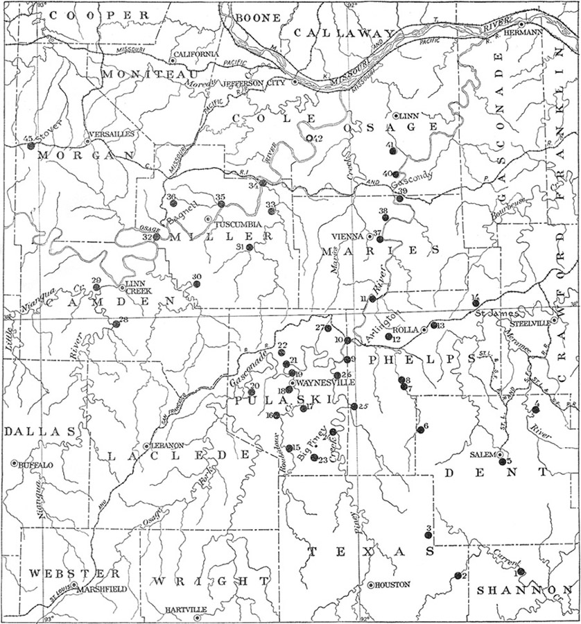
TEXAS COUNTY
SMITH CAVES (2)
On James I. Smith's land, on Big Creek, a mile above Niles, are three caves. One is merely a round opening 5 feet in width and height, soon narrowing to a crevice; it would not be mentioned except that in it was a sandstone slab such as mortars are made of. This bore no marks of use; but it had been carried in for some purpose—possibly by white men.The second cave, 50 feet from the first, has an entrance 20 feet wide and 4 to 5 feet high. Dry earth extends back for 40 feet; then come clay and fallen rocks, sloping downward toward the rear. The roof maintains its level as far as followed. No trace of occupation could be found.
The third cave, 150 yards from the second, has an entrance 35 feet wide and 20 feet high. Dry cave earth appears for 20 feet, at which distance it merges with mud containing large rocks. The cavern extends for 50 feet in daylight; water from the interior spreads over the whole floor to the inner margin of dry earth, where it collects in a little stream which passes out along the foot of one wall. The earth deposit seems to be thin. The only objects that could be found in the cave or about the entrance were a small sandstone slab, unmarked; a small piece of deer bone; and one fragment of shell-tempered pottery. Not a flake of flint was seen.
These caves are not worth working.
A fourth of a mile from the cave last mentioned is a rock grave on a ledge which projects at about 40 feet (vertically) below the top of the hill. As near as can be judged, in its present torn-up condition, the cairn was originally about 10 by 20 feet in dimensions; so there were probably two graves covered by the ordinary conical heaps of stone, the depression between them being filled up to form a single cairn.
SALTPETER CAVE (3)
Five miles west of Montauk, on Ashley Creek, is a cave noted for having two entrances which are separated by a triangular mass of rock, part of the original formation. This partition measures 30 feet across at the face of the bluff and terminates within 20 feet. The principal opening is 90 feet wide and 15 feet high. Dry cave earth extends back 90 feet, at which distance water constantly falls from the roof and flows along the foot of one wall through the minor [20]entrance. The latter is 30 feet wide, 10 feet high, and its bottom is 10 feet lower than that of the main opening. The volume of water passing out varies with the seasons, but is sufficient at times to cover the entire floor of the side chamber and keep it swept free of earth and small gravel.In the front portion of the main cavern the dry earth is 5 feet deep in its thickest part; but as it has all been leached for obtaining the saltpeter or niter diffused through it, none of it is in the original position. Some earth has also been brought from farther back, leached, and added to the pile in front; and much of this has been hauled out for fertilizer.
Near the main entrance is a large mass of breccia made up of small angular limestone fragments cemented throughout with stalagmite material; it projects several feet above the present level of the earth floor, so the character of the cavern must have changed greatly since this deposit was formed.
The only artificial object found was a fragment, about an inch across, of dark, sand-tempered pottery.
Owing to the extensive changes resulting from collecting the saltpeter, the cavern would not repay investigation.
DENT COUNTY
MAMMOTH CAVE
The statement has been made that a large dry cavern, known as the "Mammoth Cave," is in a bluff facing Current River, opposite the mouth of Ashley Creek. It could not be located; and residents in the vicinity assert that not only is there no cave near this site, but there is none known as "Mammoth" anywhere in the region. Some of them, however, had a vague idea that a cavern bearing the same name exists "away down toward Eminence; it may be on Jack's Fork."GUTHOERL CAVE
There is a cave on the farm of Peter Guthoerl, 6 miles east of Salem. It is small, with very little level space in front of it, and water from the interior runs or seeps out of it, keeping the floor muddy throughout the year.SHORT BEND CAVE (4)
Short Bend post office is 12 miles northeast of Salem. Half a mile east of it, in a bluff on the opposite side of the Meramec River, is a cave with an entrance 25 feet wide and about the same in height; the roof forming a fairly symmetrical Gothic arch. Were [21]it not for the pile of talus in front, water from the river would pour into the cavern in extreme floods; these subside very rapidly, however, and have never percolated through the barrier.It is said that persons digging in a desultory way have unearthed bones which were assumed to be those of Indians because they were "red." No description of them could be obtained, and they may not have been human bones at all.
The floor is level and dry for about 80 feet back from the entrance, but no refuse of any kind appeared, except in the pile of talus outside, which showed a small quantity of flint chips such as would be left by hunting parties in repairing their weapons.
MONEY CAVE
This is a fourth of a mile down the river from Short Bend Cave. It takes its name from the customary tradition that Indians concealed a large treasure here; the legend being authenticated by an "Indian chief" who told a white man that his people had buried much gold in a cave in this bluff, built a fire over the money, then filled the mouth of the cave with earth and rock. Some of the persons who opened many small holes in searching for the hidden wealth claim to have found ashes in this cave, behind the barrier, which is only ordinary talus. The floor is of tough clay, fallen rocks, and stalagmite, all of which, as well as the walls and ledges, were industriously dug and hammered for months by the treasure seekers.A cave with an entrance 15 feet wide, the same in height, and having a depth of 45 feet in daylight, lies between Money Cave and Short Bend Cave. In very wet seasons water runs through it from the interior; and high water backs into it from the Meramec River.
SALTPETER CAVE
This is three-fourths of a mile north of Short Bend post office, on the opposite side of the river. The arched entrance is 25 feet wide and 20 feet high. Fifteen feet from the front the cave divides into two branches about equal in size; they have never been explored to the end. One branch continues straight back for about 100 feet, then turns abruptly to the right for 50 or 60 feet, at which distance it resumes its original direction. The other branch turns directly to the right and is in daylight for 50 feet. Much of the cave earth has been hauled away for fertilizer, or leached for obtaining saltpeter, so that only a small quantity remains in front. Farther back, in both chambers, the dry earth where not disturbed is 8 to 10 feet thick.The cavern is easily accessible, close to the river, and otherwise well adapted for habitation; but careful search failed to reveal any indication that it had ever been thus used.
[22]
WATSON, TWIN, OR ONYX CAVES
The two caverns thus variously designated are on the Meramec River, 14 miles north of Salem. They are parallel to a depth of about 100 feet, being separated by only 10 or 12 feet of solid wall. The floors of both slope downward from front to rear, but not so rapidly as the roof, so that at this distance the caves apparently come to an end. But that they continue back into the hill is manifest from the appearance of the roofs. In some manner the rear portion of each has become entirely filled with earth. Probably they unite somewhere beyond this point.Either of these caves is of ample size to make an excellent shelter for a large number of people; but they are difficult of access, and no evidence whatever could be discovered indicating occupancy.
In fact, this part of the Meramec Valley does not seem to have ever been permanently inhabited. Residents say that relics, even flint implements, are seldom found in the bottom lands; and this fact was commented on by persons who have learned how common such things are in other localities. Small, rough hematite axes, however, occur in considerable quantities throughout the region. The ore outcrops at various places and solid nodules or fragments are plentiful. Chert knives or spearheads are found scattered promiscuously; and, rarely, an object made of other stone may be picked up. Very few specimens of any description are symmetrical or carefully finished.
HOUSE MOUNDS (5)
On the Dent County infirmary farm, in Spring Creek Valley, a mile and a half south of Salem, is a group of house mounds, about 50 in number. They have not been much disturbed by cultivation; the creek and a drainage ditch have cut through several of them, but, as usual, there is nothing in the construction to show their purpose.Two similar groups are on the Short Bend road, not far from Salem; another group on Peter Guthoerl's farm 6 miles east of Salem; and a fourth group, partly within the corporate limits of Salem, on the road to Rolla.
PHELPS COUNTY
BATES CAVE
On the farm of J.W. Riden, 6 miles southeast of Big Piney post office, is Bates Cave, of which every visitor to the region is speedily informed. It is entered with difficulty by sliding feet first down the inner slope of a pile of débris which fills the entrance almost to the [23]roof. Once beyond this, there is ample space. On the hillside, above the mouth, is a vertical shaft, like a well, due to the widening of a crevice; access to the interior of the cave may also be had through this by means of a long rope. Under present conditions, it would not be used except as a temporary shelter or hiding place; for which purposes bushwhackers availed themselves of its advantages during the Civil War.This cavern is renowned far beyond its merits on account of its famous "ballroom," where dances and picnics are held; artificial lights being placed on the walls. Possibly the manner in which it must be entered has something to do with its popularity.
ANOTHER "BATES CAVE"
Within a few rods of the cave above described is another, with an entrance 60 feet wide and 10 feet high. Cave earth, which is 5 feet thick above the bottom of a small stream coming from the interior, extends back to large rocks covering the floor; beyond these are rocks, wet clay, and gravel. The cave earth seems to run for some distance under the receding walls. A milk house has been constructed in it, so that excavations are not permitted.RENAUD CAVE
Four miles east of Edgar Springs, facing Little Piney, is Renaud (Rĕn´nō) Cave, on the farm of Charles E. Widener. The entrance is 50 feet wide and 10 feet high. Dry cave earth extends back for 65 feet, then comes fallen rock for 100 feet or more. A little stream runs close to the north wall. Cave earth is 5 feet deep on the bedrock at the entrance and rises toward the interior. There is much refuse within and also on the slope in front of the entrance.MARSH CAVES
A shelter cave on Henry Marsh's farm, facing Little Piney, 2 miles south of Yancy Mills, has a front 35 feet wide, 15 feet high, and runs back 60 feet. There is a wet-weather stream bed through the center. Bedrock shows at the entrance, rising toward the rear for a few feet, then becoming covered with cave earth, which probably has a maximum thickness of 2 feet. There is considerable refuse scattered about, but it is doubtful whether the shallow deposit would repay investigation.WILD-HOG CAVE
A fourth of a mile from the above cave is one known as "Wild-hog Cave," because in pioneer days these animals gathered here for shelter and protection. It is a small, tunnel-like affair, with a solid rock floor, and extends farther into the hill than anyone has ever dared to venture.[24]
SHELTERS
Two small rock shelters near the Wild-hog Cave may have been resorted to as temporary camping places.PHELPS CAVE
A cave on the farm of James Phelps, 2 miles south of Yancy Mills, is described as small, with a narrow entrance."KEY ROCKS"
Near Yancy Mills there is something known as "the Key Rocks." It can not be found by a stranger and no guide was available at the time the place was sought. It is described as a small, deep, circular hole in solid rock, in which were many stone covers or lids, one above another, gradually diminishing in size and "cut to fit down on each other." It is probably due to stream erosion.JONES CAVE
On Little Piney, half a mile south from Yancy Mills, is a large cave on the Jones farm. It is said to have a large entrance and much earth on the floor. As the owner uses it for a warehouse in which to store fruits and vegetables and utilizes the stream flowing through it for preserving milk and butter, no examination could be made.YANCY MILLS CAVE
There is a small, shallow cave near the top of the bluff, half a mile north of Yancy Mills. It contains no evidence of occupation, except that walls and ceiling are blackened with smoke, due, probably, to modern refugees or hunters.LANE MOUND (7)
It was reported, too late to visit the site, that on George Lane's farm, on Little Piney, a mile north of Yancy Mills, is a mound "8 feet high, built of earth," and surrounded with the usual evidences of a village site, scattered over the level bottom on which it stands.CAIRNS ON LOST HILL, AT MOUTH OF GOURD CREEK (8)
Gourd Creek flows into the east side of Little Piney River 12 miles southwest of Rolla. It is less than 4 miles long, and but for three or four large springs near its source, which keep its volume fairly uniform, would be dry most of the year.Parallel with it, a short distance to the southward, is a ravine several miles in length, known as Coal Pit Hollow. This originally [25]discharged its drainage into Little Piney about half a mile above the mouth of Gourd Creek. A ravine tributary to the latter, near its mouth, has worked back until it has captured the flow of Coal Pit. The lower end of the stream bed thus abandoned now forms a gap or depression with a slight incline from the center in both directions. The crest of the deserted portion is about 50 to 60 feet above the present level of Little Piney. The hill inclosed by this quadrilateral drainage is about a fourth of a mile in length along its top, has a direction almost north and south, with a nearly uniform slope along the summit, the southern point being somewhat higher than that at the north, and terminates abruptly at each end. The sides descend at once from the center line of the ridge, like a roof with a slightly rounded comb.
On account of its isolated position the eminence is locally known as "Lost Hill." It is not to be confused, however, with several similar formations in this region, to which the same term is applied and which may owe their existence to a like cause, or may be due to cut-offs by streams.
On the top of this particular Lost Hill are six cairns, five of them near the northern end, the sixth just where the ridge breaks off to the south. The margins are uncertain owing to the upper stones being scattered by hunters as well as by credulous individuals who are firmly fixed in the belief that all such "rock piles" contain gold hidden by Indians.
So far as can now be determined the five at the northern end were 16 to 18 feet across as left by the builders, the southernmost one being somewhat smaller. All are in uncleared land, and crevices between the stones are filled with a tangled mass of roots from the trees and bushes growing on and around them.
The relative positions are about thus, measurements being made on the earth between the scattered stones: (1) 10 feet, (2) 10 feet, (3) 50 feet, (4) 10 feet, (5) 1,000 feet, (6). The distance from (5) to (6) is estimated by stepping and may vary considerably either way from the measure given.
Cairns (1), (2), and (3) were thoroughly excavated.
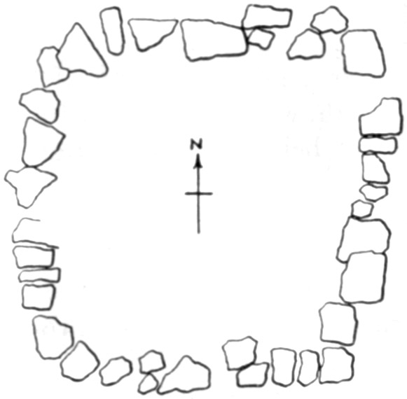
Cairn (1)
This, the farthest north, was about 16 by 17 feet within the original limits. When the outer loose rocks were removed there was disclosed a wall of flat stones on the natural surface, so laid as to form an inclosure apparently intended to be practically square. It measured, across the center, from outside to outside, about 14 feet from north to south by 12 feet from east to west. The north and south walls [26]were straight, the others outwardly curved. The approximate outline is shown in figure 1. In most parts the wall was only one stone high; in a few places there was another rock laid up. Over and within this wall had been piled loose stones, ranging in size from small pebbles to fragments of 150 pounds in weight, to form a heap whose original height was about 2 feet.When all these were cleared away the space within the wall was found to measure 9 feet in each direction. Three feet from the middle of the west wall was a fragment of a child's skull lying on the undisturbed angular gravel which forms the natural surface on this ridge except where a small amount of recently decayed humus may be held by rocks and roots. Halfway between the center and the north wall was the top of an adult skull, with three fragments of long bones. These, which were much gnawed by rodents, were in black earth, evidently the former home of some burrowing animal.
A foot north of the infant's skull were small remnants of an adult's skull, probably belonging with the piece first found. There were also some scraps of animal bones, much gnawed.
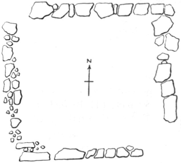
Cairn (2)
This measured from 16 to 18 feet across to the outer edge of the loose stones, and about 30 inches high. Under the top rocks was a rough wall similar to that in Cairn (1), but all the sides were nearly straight. The outline is given in figure 2. The outside measurements, across the center, were 15 feet each way. There were more stones in this wall than in the first; mostly there were two, and in some places three, superposed.Extending from north to south across the middle of the vault was a row of large slabs standing on edge with their tops leaning toward the east. Their inclination varied from nearly horizontal to nearly [27]vertical; so it would appear that they were not placed thus intentionally but had settled irregularly. Probably they had formed the covering of a pen or vault, of poles or timbers, in which a body had been placed.
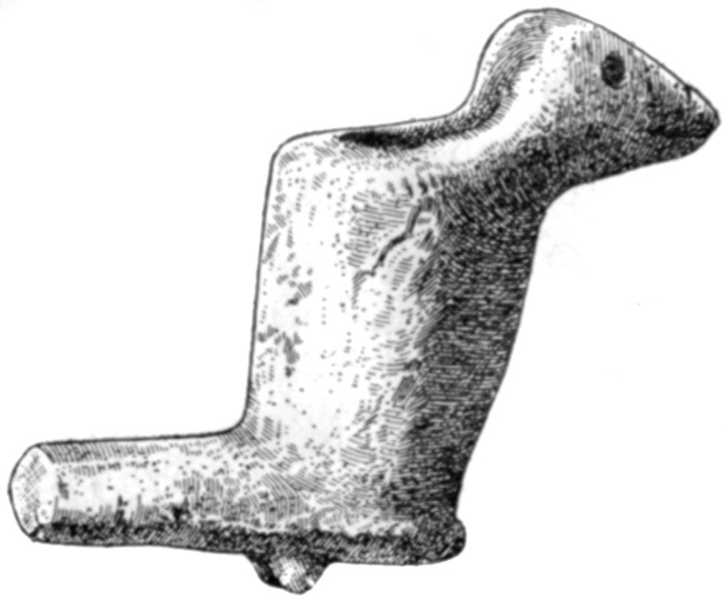
Close to these inclined slabs, near the north wall of the vault, was the effigy pipe shown in figure 3. It is made of a fine-grained sandstone and seems intended to represent a buzzard with an exaggerated tail, though the beak is more like that of a crow. This specimen lay between two flat rocks which were separated by a little earth and gravel, but there were no traces of bone with it or near it.
At a slightly lower level than the pipe were several flat stones standing at various angles. When these were removed there were found fragmentary remains of at least three adults, lying in confusion, as if only the folded dismembered skeletons had been placed here. They lay on a floor of slabs which, in turn, rested upon undisturbed gravel.
The facts observed are difficult to interpret, as the original order was so broken up; but it would seem that as a preliminary to the burial of bodies or skeletons, the superficial earth had been scraped away and a rough stone floor laid, on which the bundled or folded remains were placed and at least partially covered with earth and gravel. Other flat rocks were then laid over them, either directly on the earth or more probably supported by poles placed across, whose decay had allowed them to fall into the confusion in which they were found.
A small flint knife was among the remains.
The pipe, being at a little distance from these bones, would suggest another interment; but as no trace of such remained it may have been placed as an afterthought or a separate deposit.
From these skeletons row after row of the slanting rocks continued to the inner side of the eastern wall. Two feet east of the pipe was a skull on its right side, the back against a small flat rock. It was crushed flat, and only a small part of it remained. Possibly it had turned after burial, as fragments of other bones were found here and there toward the south from it, indicating an extended burial. The teeth were hard, solid, and much worn. The bones found were more or less gnawed, and among them were scraps, probably of food [28]animals, burned into charcoal. No bones found could be saved, as they were very soft.
Cairn (3)
This was similar in construction to (1) and (2), as is shown in figure 4. The wall, along the outside, measured 14 feet on the south, 13 feet on the north, 15 feet on the west, and 14 feet on the east. The inclosed space was 10 feet across each way. Some one had dug out much of the south end; the northern end was undisturbed.The prior excavation had barely missed, near the west wall, a few fragments of an adult skull and three teeth. About even with the middle point of the west wall, 2 feet from it, was evidence of the burial of an adult—pieces of bone and skull, and some teeth. North of these, near the northwest corner, were fragments of two adult skulls, with one of which were some beads made of shells of water snails; 18 of these were recovered, all more or less decayed. Between these two skulls were parts of a child's skull, the teeth not yet through the bone.
Inclined flat stones in the eastern half of the grave, the tops leaning eastward, denoted other burials; but nothing was found under them, although small flat stones laid on the original surface indicated the bottom of a grave.
Evidently several burials, of which all traces have disappeared, were made in this vault.
Owing to the practical identity of these three graves, the poor returns, and the difficulty of working in a tangled mass of tough roots without displacing the stones so greatly that their proper position became a perplexing question, the remaining three were not excavated.
EXPLORATION OF THE GOURD CREEK CAVE (8)
Near the mouth of Gourd Creek, on the north side, is a cave which has acquired much local reputation from its size and also from the evidence it affords of a long-continued occupation by the aborigines. It is easily reached from the road which passes in front; wagons can be driven into it and there is ample space for them to turn and pass out. Formerly it was much resorted to as a pleasant place for [29]social gatherings; but in recent years it has been used as a barn and storehouse. The owner, Mr. Valentine Allen, gave cheerful permission for all the excavation that was desired, subject only to the proviso that the floor be put back in condition suitable for the purposes for which he needed it. And it is only fair to state that he was not at all difficult to satisfy in this respect.A stream coming from the interior had a flow at the close of the long drought in 1918 sufficient to fill a 2-inch pipe with a rapid fall; in wet seasons the water spreads from wall to wall until it comes to within 100 feet of the mouth.
Back in the cave, where the slope is greater, it has sufficient volume and force to carry away all pebbles smaller than coarse gravel and the material that finds lodgment among the stones.
The cave is easily traversed for almost 600 feet; beyond this are narrow crevices and tortuous passages, where explorers must frequently crawl or clamber. One adventurous party proceeded until they reached an opening on the other side of the hill; but this was so choked by fallen rock and débris from the hillside as to be impassable. In storms a strong breeze passes through the main entrance, in or out in accordance with the direction of the wind.
Owing to the irregular outline of the cliffs, the width of the entrance can not be accurately given. From side to side, well under the front of the ceiling the distance is 110 feet. Two hundred feet toward the interior it contracts to 50 feet. At the entrance the walls are vertical to a height of 25 feet; a short curve at the top on either side, due to the breaking away of the ledges, connects them with the roof, which is somewhat higher. Being a single massive stratum, the top is practically horizontal, but the floor constantly rises from the front with a slight and fairly uniform grade. The front chamber is straight and well lighted for 300 feet, where it turns abruptly westward; from this point the floor is solid rock which the water keeps comparatively free from any loose matter except heavy blocks from the walls or top.
Beginning at the entrance is a deposit whose farthest extension reaches 100 feet into the cavern. It is composed to a small extent of sand and clay carried by the stream, and of earth blown or washed in from the outside; but, as investigation proved, it is mainly ashes from prehistoric fires. The surface of this deposit, especially toward the inner end, is very uneven, being higher near the walls than through the central portion. This is due to two causes: In very wet seasons water has carried away much of it, and a large amount has been hauled out by the owner to scatter over his fields as a fertilizer. He reports that in the course of this work he found quantities of pottery fragments, broken bones, flints, and "two or three" human skeletons, with fragments of others. This is the basis for the assertion, [30]frequently heard, that "many" or "very many" burials had been made here. The only human remains which he saved are the complete skull of an adult, remarkably preserved and apparently that of a white woman; a rather large lower jaw, of a man; a few long bones; and parts of skulls and jaws of three or four children.
From comments made and questions asked by visitors while the investigation was in progress, it seems that bones and teeth of deer and other animals are mistaken for those of people. No human bones were uncovered in this work, except as noted below.
There is a firm belief in the community that somewhere in this cave is concealed $100,000 in gold, seven "pony loads" in all, which was put here by an old squaw, sole survivor of a massacre by which her tribe was exterminated. Much of the irregularity of surface noted in the deposits is due to the efforts of persons trying to find this money.
Before starting the work it was necessary to deepen the little stream, which had cut its way through the accumulation much nearer to the western than to the eastern wall of the cavern, in order to allow the water to run out of the lower end of the deposit. Thorough drainage of the whole mass was impossible, as water continually seeped in from the gravel bed farther up, a condition which could not be remedied.
Bedrock was reached at a depth of 3 feet below the channel. The lower 2 feet of this distance was through a black, mucky substance which was so tough and sticky that removing it was like digging through a bog.
Following the bedrock as a floor, the western side of the deposit was first examined. It had a width of 35 feet at the mouth of the cave, gradually narrowing inward for a distance of 75 feet, where it terminated at the level of the water. Its greatest elevation, at the side of the entrance, was about 10 feet; but this does not mean that its thickness was so much at any point, as the rock sloped upward quite as rapidly as the surface. So many stones were scattered through it, fallen from the sides and roof, or rolled in from the outside where they had broken loose from the cliff, that not more than one-fourth of the area could be excavated. These rocks varied in size from cobblestones to blocks weighing 3 or 4 tons. They were at all levels, some lying on the rock floor, others only slightly imbedded in the earth. Yet the superficial accumulation extended under all of them except such as were in direct contact with the bedrock, proving that the cave was occupied throughout the period in which such downfalls occurred. An additional evidence of age is the fact that the usual débris, such as bones, flints, pottery, ashes, etc., lay in immediate contact with the bedrock where this has [31]weathered to a chalky consistency from 2 to 4 inches in depth since these objects were left there.
Owing to the uneven surface of both the bedrock and the deposits on it, the thickness of the latter varied from 1 to 3 feet—not including the muck, which last, however, disappeared at the level where the rock rose above the water line. But, whatever the depth, more than half the overlying material was pure ashes; either resting undisturbed on the fire beds, or piled in irregular masses, where they had been thrown to get them out of the way. The largest ash bed was near the wall; it measured from 4 to 7 feet across, with a very uneven outline, as if many fires had been made there at different times.
The objects discovered included flint knives, spearheads, arrowheads (mostly broken), with many spalls and chips; potsherds (only very small pieces were found); animal bones; mussel shells; bone perforators; chert nodules, more or less flaked; two stone beads or buttons; a small fragment of a pipe; but no mortars, hammers, pestles, cooking-stones, or hatchets, such as are usually found on the sites of Indian villages. None of the pottery was decorated, but most of it was cord-marked, though some of it was so smoothed and polished as almost to appear glazed. It varied through a wide range of color, thickness, and general appearance, and was noticeably deficient in quantity. In fact, the west side of the cave had less the appearance of a permanently occupied site than of a camping place which was used as a temporary resort by traveling or hunting parties; but at the same time the depth and amount of ashes showed that it had afforded shelter through a long period.
The excavation on this side included all the space bounded by the ditch, the wall, the mass of rocks piled at the entrance, and the water-soaked earth toward the interior. The muck, and the large blocks scattered around, prevented a complete clearing out; but the part thoroughly examined had an area of about 600 square feet, perhaps a little more. No human bones were found, in spite of reports of their discovery and reburial by treasure hunters in the past; and there was wide disagreement on the part of visitors, who were also present when the bones were found, as to the number of such interments. All finally conceded that there was only one adult skull, though there was much argument as to the number of children's remains discovered, the person who was blessed with the largest memory insisting there were 13 "all in a pile." There was also some discussion as to whether the remains were actually found near the west wall or had been carried over there and reinterred after being exhumed on the east side.
These particulars are given merely to show how little reliance is to be placed upon the statements of perfectly truthful persons who [32]do not observe closely, whose memory plays them tricks, who are not especially interested in the matter under discussion, or whose recollections naturally become jumbled after several years have elapsed.
Work was next begun on the east side, at the edge of the drainage trench. Bedrock was reached as before, under 2 feet of muck, and was weathered until quite soft and of a yellowish hue, for 3 or 4 inches below its surface. An effort was made to keep on the rock as a floor, removing all the muck; but this was so water soaked, so tenacious, and so filled with chert and limestone gravel that it could not be managed with either pick or shovel. A little of the gravel had no doubt fallen from the roof; but nearly all of this mingled material had washed down from the interior, as it was entirely similar, except for its dark color, to that forming the floor farther in. Consequently it was necessary to limit the explorations to that part of the deposit which lay above the wet black mass. Numerous attempts were made to ascertain the thickness of the latter; but water, gravel, and slush oozed or slid into the hole as fast as they could be removed, and it was impossible to reach the bottom. The eastward dip of the rock floor, as noted on the western side of the cave, no doubt continues entirely across. If such be the case, then the original drainage line was against the foot of the eastern wall. Later, because the channel was obstructed by talus, the stream was forced more and more to the west, saturating, up to the level of its final outlet, the earth and ashes which had accumulated. It may be, however, that either this line of drainage, or the mass of talus in front of the cave, is of comparatively recent origin. Such accumulations as those described would be impossible under present conditions. At any rate, this deposit of muck, then dry, started from the floor of the cave with the earliest occupation; for artificial objects of the same character that occurred in the dry deposit above were found in it to a depth of 3 or 4 inches. They may continue to the bedrock, but on account of the standing water no satisfactory observations could be made below the level indicated.
Lying above the muck and, as intimated, practically continuous with it, was an accumulation of ashes with which here and there some earth was mingled, though the latter made only a small proportion of the entire mass, and was sometimes entirely lacking from top to bottom. They were principally in strata or irregular layers, lying undisturbed where fires had been made; but there were also many scattered piles, usually small, where they had been thrown to get them out of the way.
The excavation on the eastern side began with a trench 25 feet wide. When this had been carried about the same distance toward the wall, rocks and earth rolled and washed in from the outside were encountered on the right, the side toward the mouth of the cavern. [33]These reached from the bottom to the surface, and were continuous with the bank of talus. As results had been meager along here, the sides of the trench were turned to the northward and northwestward. The entire trench was 43 feet long and varied in width from 30 feet in the central parts to 18 feet at the extreme northern end. The left face reached, in its entire length, nearly to the drain; on the right side the eastern wall of the cavern was uncovered for 15 feet. It embraced nearly all the area not previously dug by others, except a triangular space at the east side of the entrance, filled with large stones, as just stated.
Near the middle of the excavated area was a heap of large fallen rocks, fully a carload in all; some of them imbedded in the muck, others barely penetrating the surface of the latest deposits. Ashes lay under and between all of them, proving this side also had been inhabited before the first of them had become loose, and that occupancy was practically continuous until the last one had fallen. The inmates, recognizing the danger, may have knocked these down.
The greatest depth of ashes found in any part of the excavation was 7 feet; but it may have been greater previous to any disturbance; nor does this include such as may be present in the muck. There were unbroken layers as much as 8 inches thick covering spaces 5 to 10 feet across; many smaller, intact patches; and numerous masses, from a peck to a bushel in volume, removed from fire beds elsewhere. Charcoal among them showed that bark and dead wood, principally oak, was the main reliance for fuel.
The wrought objects found were flints, mostly broken or of rough finish; very many small fragments of pottery; mortars made of sandstone slabs; hammerstones or pestles; bone perforators; mussel shells, some pierced for suspension or for attachment of a handle, some with outer surfaces and edges dressed for use as spoons; hematite ore, in the rough or rubbed to procure paint. There was a great abundance of bones from animals used for food, mostly deer, though elk, bear, many smaller mammals, turtles, tortoises, turkeys, and other birds were well represented. Singularly enough, when the plentiful supply of fish in all the streams of this region is considered, none of their bones or scales were found, although the ashes would have preserved them perfectly. Nor were there many burned rocks, in view of the amount of pottery and the number of bones which showed that they had been boiled. Perhaps such stones had crumbled or were thrown outside when near disintegration.
There is a consensus of belief, or at least of statement, in the neighborhood that many human skeletons have been dug out close to the east wall. In the only part reached during this work—which took in about all that had not been searched by others—rocks lay along the wall, so large and so numerous that no graves could have [34]been dug behind or between them. By careful and persistent questioning it was established that skeletons had been found in two places and a detached jaw in another.
A human skull, which was very soft and fell to pieces when uncovered, was found on, and slightly pressed into, the muck at a point 15 feet from the wall; there were no other bones about it, though a rough stone hammer, whose presence was probably accidental, lay close by. A single human molar was lying among some ashes.
These were the only human remains found during the work, except two adult femurs of different individuals, and fragments of a skull and some other bones from a child and from an infant, all of which lay close to the wall where they had been thrown and slightly covered by parties previously working here.
As the depth of the wet material on the rock floor of the eastern side of this cavern is unknown, interesting results might be obtained by a careful examination of it; but this can not be made until a ditch is dug through it of sufficient depth to drain it thoroughly.
Slight investigation outside the entrance showed a large amount of broken bones, pottery, and flint; and this dump may contain even more material than was found in an equal volume in the cavern. But in addition to the rocks of all sizes broken off from the cliff, there were also many which had rolled down from the hillside above; and all these were so interlaced with roots as to make digging very difficult and unsatisfactory. Consequently further exploration at this site was deemed undesirable.
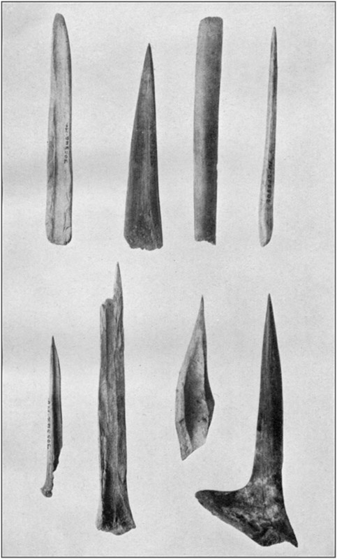
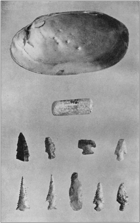
Pointed bone and antler implements from Gourd Creek Cave are shown in plate 4. A shell knife, a bead from a fragment of sea shell, and types of flint arrowheads appear in plate 5.
There is a village site on Gourd Creek bottom, at the foot of Lost Hill, and a little below the cave. Three small earth mounds are plowed nearly level.
A small village site is located on the east bank of Little Piney, half a mile below Gourd Creek.
In the bluff facing Little Piney, a mile below Gourd Creek, on the opposite side, is a small, shallow cave with a low roof. Water cracks on the floor show that it is sometimes flooded. No signs of use are apparent.
On the hill over the cave just mentioned is a cairn, now destroyed.
ONYX CAVE (9)
Five miles southwest of Arlington, near the Boiling Spring in the Gasconade, is Onyx Cave, so named because much workable [35]stalagmite occurs in it. It has a number of branches, some of which have been explored for several hundred yards without coming to the end. The entrance is 90 feet in width. A pile of talus at the front, lying partly inside the cavern, reaches nearly to the roof; it has a height of 26 to 28 feet above the level of the wet, muddy floor. Drainage is through a small aperture in the north wall, whose outlet is not known. Apparently the bedrock lies at a considerable depth; it is not visible at any point in the steep ravine leading from the mouth of the cave to the river. Formerly a large quantity of ashes covered much of the inner slope of the talus, where it is protected from the weather; but most of them have been hauled away to scatter over the fields. They extend to a greater depth than any digging was ever carried. The cavern has long been a refuge for stock, and this, with the trampling of many visitors, has mingled all the superficial deposits, so that, while ashes may be seen mixed with the débris, no ash beds are now to be found.There must be a very pronounced cavernous condition in this vicinity. At a number of places, even extending to a distance of 2 miles from Onyx Cave, the passage of a wagon produces a rumbling sound, indicative of a cavity at no great depth. There are also many sink holes, some closed, forming ponds, others with free openings. They are so numerous that no one of them drains any considerable area. The largest of these sinks measures from top to top of its slopes about three-fourths of a mile long and half a mile wide. Around much of its margin are vertical cliffs; there are few places where descent is practicable. It is 300 feet deep, perhaps more; for when the Gasconade, more than a mile away, is at flood stage the water from it, backing through an underground passage, breaks in at two different points not at the same elevation, and covers the nearly level floor of the depression, about 15 acres in area, to a depth or 15 to 20 feet.
Another sink, near this, is conical in form, a fourth of a mile across and more than 200 feet deep.
GOAT BLUFF CAVE (10)
Goat Bluff Cave, 4 miles west of Arlington, on the left bank of the Gasconade, is at the foot of a vertical cliff 50 feet high, the slope above rising about as much higher to the crest of the ridge. A few yards to the west is a slight ravine through which, with a little effort, the top of the hill may be reached. In front, the declivity, while steep as earth will lie, furnishes fairly easy passage to and from the river which lies 200 feet below.The entrance to the cave is an arch 30 feet high and 75 feet wide, facing a little east of south. The width holds nearly the same for [36]90 feet, whence it rapidly contracts to 20 feet; the roof meanwhile descending to 10 feet above the floor. The extreme rear of this chamber is nearly filled with large blocks of stone. At the front part the floor is several feet higher along the west wall than at the east; this condition being due to the combined action of accumulation from the ravine above mentioned and erosion by a little rivulet which emerges from a crevice 30 feet within the entrance and flows at the foot of the east wall. Beyond this the floor is practically level across the inclosed space, with a slight and uniform ascent toward the rear. No evidence of rock bottom appears at any point.
A preliminary cut at the outer margin of the cave showed two distinct, sharply separated strata. The lower is a red or yellow clay containing much angular gravel such as usually results from disintegration of limestone in which chert is abundant. Above this is a deposit of very loose fine material. Toward the rear the upper deposit had been disturbed by "curiosity seekers," who reported finding much evidence of prehistoric occupation, such as ashes, charcoal, fragments of pottery, and worked flint, as well as several skeletons, the latter "in a sitting position." The last part of this statement is a mistake. The bodies were closely flexed and placed on the side; the bones settled to the bottom of the grave, while the skull, if intact, is reached first by excavators and the conclusion drawn at once that it is "on top of the other bones." This error of observation is quite common among relic hunters, and is not unknown among student investigators.
In order to dispose of material removed in excavating, it was necessary to start a trench from the slope outside the mouth of the cave. As it progressed the substratum of clay became wetter and more difficult to dig. At 40 feet from the beginning, where the trench was 11 feet deep, the seeping water accumulated until it covered the bottom of the trench, so that no greater depth could be reached. A crowbar forced downward for 18 inches, as far as it could be driven, did not reach solid bottom. Not the slightest trace of human agency was found anywhere below the top of the clay, and from this point excavations were confined to the upper stratum, to which alone the following description is applicable.
This deposit was composed partly of fine loose earth, probably carried in by the wind and on the feet of persons and animals; partly of roof dust; and partly of ashes. A considerable portion of it was roughly stratified in layers of varying extent and thickness, though much of it was irregular, and it was mingled throughout with campsite débris. Occasional layers of roof dust several feet across in any direction and of varying thickness, from a faint streak to 6 inches, so closely resembled ashes that many persons could not be convinced of its true character. Its occurrence in this manner indicates that [37]during considerable periods the cave was unoccupied, or at most used only as a temporary refuge. The intermittent character of occupancy is also shown by the distinct segregation of numerous successive layers of kitchen refuse.
About 10 feet within the point where a vertical line from the front edge of the roof would meet the floor the skeleton of a very young infant was found above and in contact with two thick angular blocks of limestone weighing 300 to 400 pounds. These rested on the red clay and had fallen from the roof. The thickness of earth above the bones was about 3 feet.
Ten feet farther in, on the clay floor, under almost exactly 5 feet of undisturbed material, were five flat stones. Three were of sandstone, the largest about 25 pounds in weight, such as can be found in place only on top of the hill. They were carefully arranged for use as a fire bed; on and around them were potsherds, flint chips, animal and bird bones, and a bone awl. This was the greatest depth at which artificial objects were found; and their position shows them to be as ancient as anything discovered.
At 25 feet in an interesting find was made. Eighteen inches below the surface of the floor, in a mass of mingled charcoal, ashes, mussel shells, flint chips, and other aboriginal refuse, was a small piece of glass, apparently part of a bottle, shown in figure 5. Above it and extending for several feet on every side was an unbroken stratum of root dust from 2 to 4 inches thick. Above this, in turn were several thin, undisturbed layers of camp refuse, about 6 inches in all, and then 6 inches of the loose, incoherent surface earth. This discovery is susceptible of two interpretations. One is that between the date when Indians could procure articles from the whites and the date at which they abandoned this fireplace there was time for the accumulation of the given thickness of disintegrated material from the roof, the cave, or at least this part of it, not being used meanwhile for a habitation; then for the accumulation of several distinct layers of camp refuse; and finally for the depositing of the cave earth over it all. This hypothesis is unreasonable. While the rate of formation of either roof dust or stalagmite is extremely variable, so that it is not safe to predicate a definite antiquity for objects found beneath even a considerable thickness of either, at the same time the small area involved precludes the idea that a number of occupants sufficient to account for the volume of débris could have lived here unless we allow a [38]much longer period than would necessarily elapse within the dates indicated. The other, quite plausible, interpretation is that the glass was dragged to the spot by a ground hog or other animal whose runway had become obliterated by settling of the loose material through which it was made.
The only purpose of elaborating this subject is to guard investigators against attaching too much importance to an article found under such or similar conditions, whether it be a "palaeolithic type," or an "object undoubtedly of European origin."
Thirty-five feet in, under three flat slabs whose upper surface was a little more than 3 feet below the floor, was an adult skeleton, on the back, knees flexed to the chest. The body had been laid in a cavity dug in the clay to a depth of 6 inches. The bones were well preserved and fresh looking, but light and fragile.
Forty feet in, 3½ feet down, was a flat stone under which were two skulls. One, shown in plate 6, was perfect, with a full set of sound teeth; from the other, seen in plate 7, the lower jaw was missing. No other bones were found except two cervical vertebræ, belonging to the smaller skull. Undisturbed stratified ashes and roof dust were 30 inches thick above the stone.
To this point the trench was not dug to a greater width than 15 feet; it was now gradually extended to a width of 40 feet to include most of the central portion.
Sixty feet in, in the upper part of the clay, like all the human bones discovered, was a skull with the scapulæ, a few ribs, and one arm bone. The lower jaw was missing, and two phalanges were inside the skull. With the scapulæ was one of a much smaller person. Eighteen inches from these bones, and 6 inches higher, was part of a lower jaw.
At 50 to 60 feet in, on the clay stratum, lay a slab 10 to 12 feet across and of varying thickness up to 18 inches or more. It fell from the roof so long ago that the latter is worn and smoothed above it in much the same way as at other parts. At the east edge of this slab was a skull so soft and crushed that it could be taken out only in small fragments; the teeth were very slightly worn, though of large size. A few traces of other bones were found; not enough to identify. At the north edge of the slab were two skulls, one of which is shown in plate 8; the other, which belonged to a young person, is given in plate 9. The limb bones, scapulæ, and hip bones, with a few others, were in a small pile at one side; but neither lower jaw, no ribs, and only a few vertebræ were found.
About 65 feet in, near the west side, an inverted pot which shows no marks of use was found in a mass of ashes filling a cavity the size of a half bushel, which had been dug in the upper deposit. Scattered here and there among the ashes were also some mussel [39]shells and broken deer bones; but the presence of these was probably not intentional, as the whole arrangement seemed to have the nature of a votive offering. This was the only perfect vessel found in the entire course of the explorations. It is of the ordinary "cocoanut form," and is represented in figure 6.
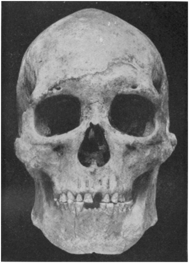
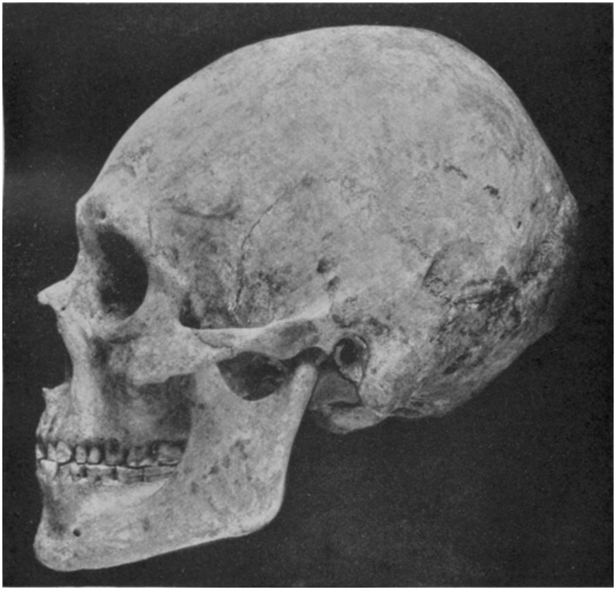
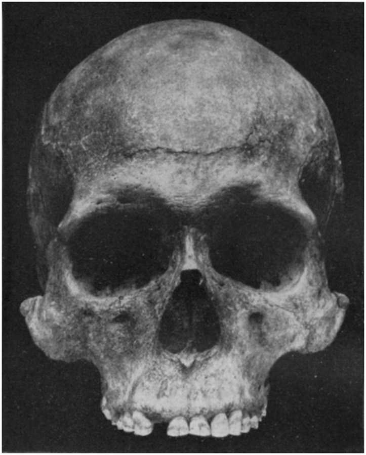
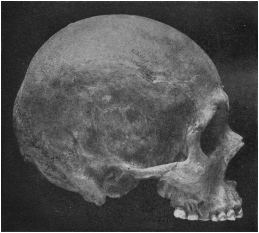
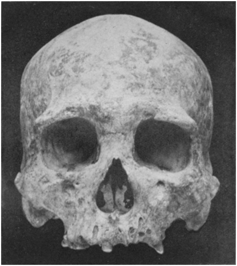
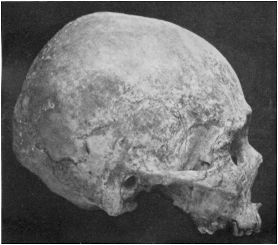
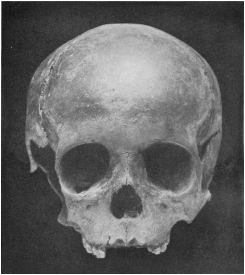
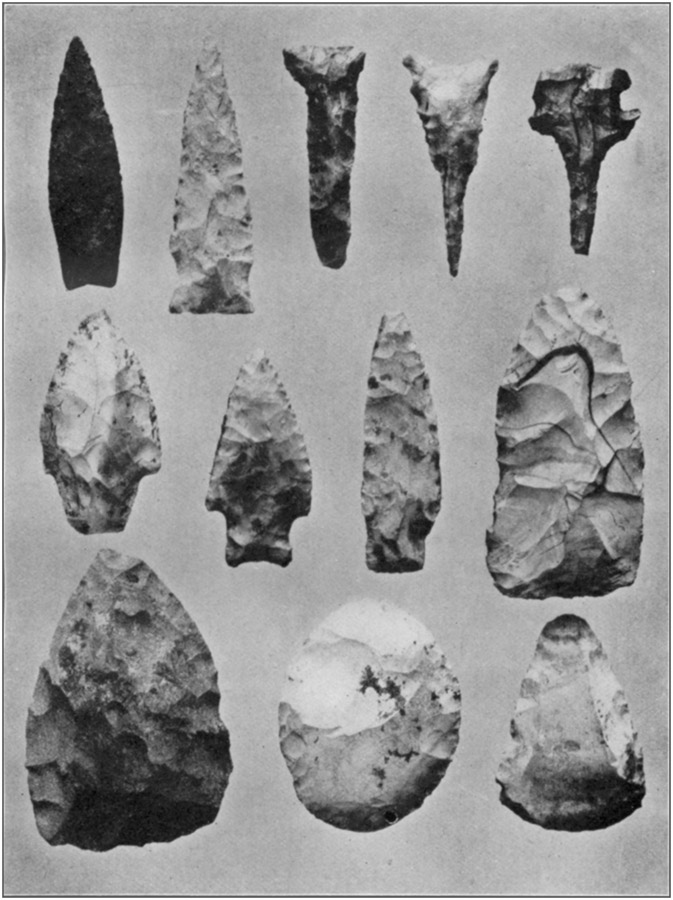
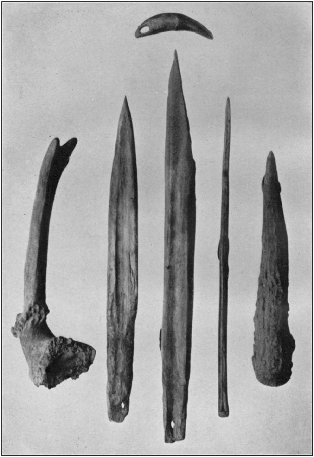
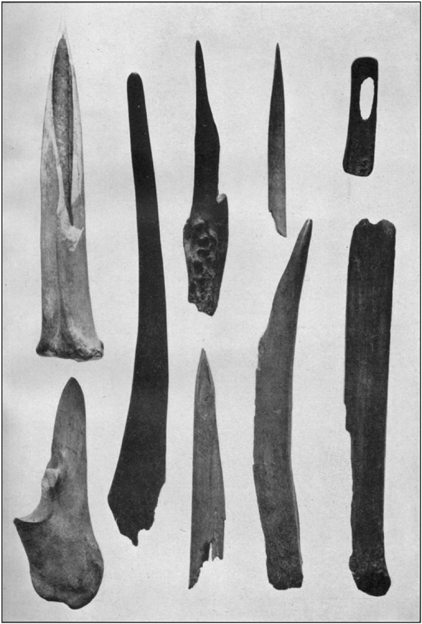
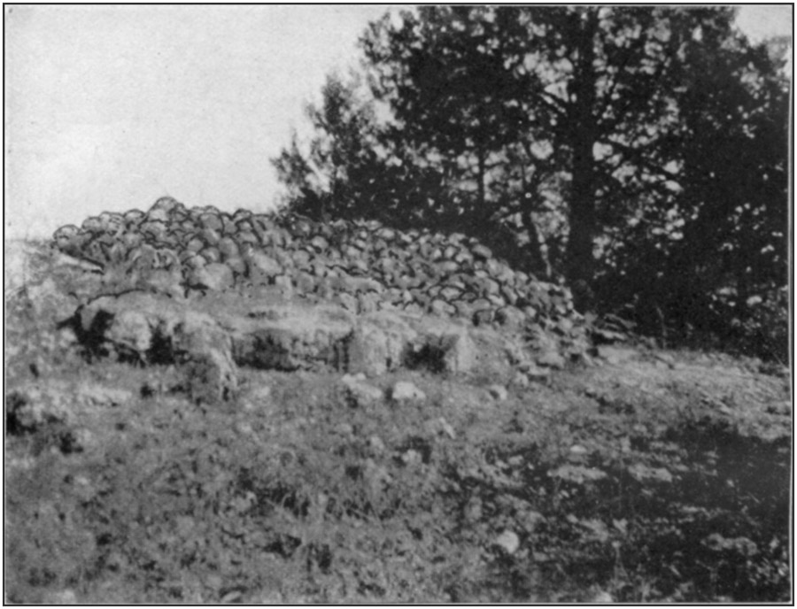
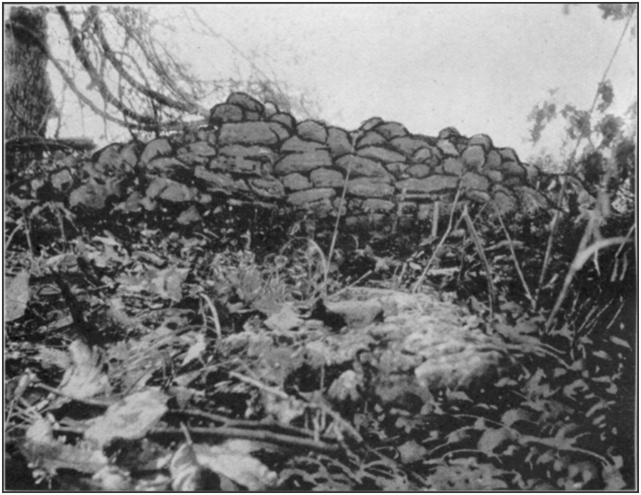
Seventy feet in was a skeleton, on the left side; the bones were soft and came out in small fragments. This was fully 6 feet below the present surface, but some of this earth was piled up from earlier excavations.
Beyond this point the ground had been dug over to such an extent that further examination seemed useless, and the work was concluded.
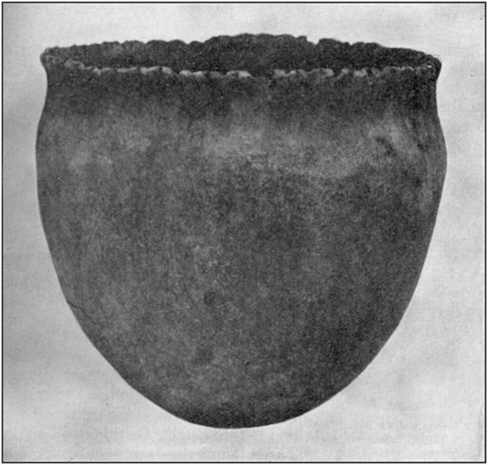
Throughout the deposit of black earth, ashes, and roof dust were scattered irregularly arrowheads and knives of flint, some types of which are seen in plate 10; mussel shells; fragments of bones from food animals; bone perforators, some of which are shown in plates 11 and 12; potsherds; hammers; pestles; two or three mortars; a grooved stone ax of granitic rock, presented in figure 7; and an abundance of flint chips.
[40]There is a small cave near the top of the bluff facing the Gasconade, a short distance above the mouth of Little Piney. Within a few yards of the entrance earth and rock carried in from a sink on top of the hill fill the cavity to the roof. Water runs through after every hard rain.
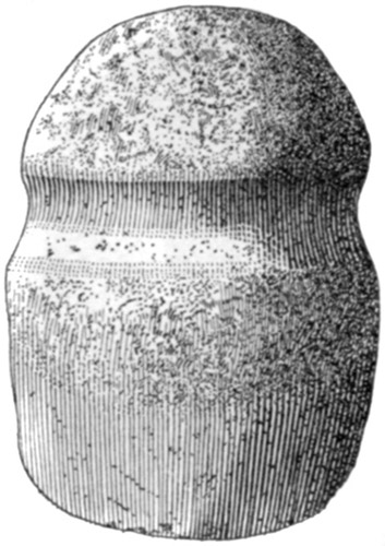
Three small cairns, built of small stones, stood on the point of the bluff at the junction of Little Piney and the Gasconade. All are destroyed.
On the edge of a high cliff over the Gasconade, 2 miles north of Arlington, are three cairns, destroyed.
In Bryant's Bluff, facing the Gasconade 3 miles below Jerome, are two rock shelters, neither of them more than 20 feet across in any direction. In both are shells, bones, and pottery; a rough stone hammer was found in one. Exposure of bedrock on the outside shows that the earth deposit in either is not over 2 or 3 feet deep.
On top of Bryant's Bluff are four cairns, all of them torn up. The extreme limit of the scattered stone is about 20 feet; so the cairns were probably 12 to 15 feet in diameter.
At the mouth of Turkey-pen Slough, 4 miles north of Arlington, is a terrace with steep banks on two sides, next to the river and to the slough. On this stood a village. Three house sites are plainly marked by the refuse around, and there may be others; vegetation is very dense. Mussel shells and burned stones are abundant, and many flint implements have been picked up.
CAIRNS AT SUGAR TREE CAMP (11)
Six miles north of Arlington is a clubhouse known as Sugar Tree Camp. A short distance from the building is a high vertical cliff rising almost directly from the Gasconade. The top of this cliff, near the front, is of solid rock, almost bare of timber or brush, and in a row along it close to the edge are seven cairns, all now so defaced that any attempt at investigation is useless. The smallest, at one end of the row, is of the common circular form, about 12 feet in diameter. Three others seem to be of the same type; but their appearance may be due to their destruction. One is shown in plate [41]13, a. The other three are walled vaults. The largest, at the other end of the row, was built up like a foundation wall of sandstone slabs. It is rectangular in form, measuring on the outside 16 by 28 feet. All the walls are more or less destroyed; the small portion of one remaining is shown in plate 13, b. Two "walled-up graves" reported on the first ridge north of Sugar Tree Camp, and one reported on the first ridge south, never existed. There is a small cairn on a high peak half a mile east of the camp.TICK CREEK CAVE
In a ravine which joins Tick Creek about 2 miles from where the latter flows into the Gasconade, and about 12 miles north of Arlington, is a large cave known as the Saltpeter Cave.The opening is wide and high, but the mouth and floor are much obstructed by large fallen rocks and the bottom is constantly wet from wall to wall with running and seeping water.
There is another entrance to this cavern around a corner of the bluff and much higher up on its face. This opening is small and the sloping passage from it to the cavern is almost closed in places by drip formation.
It was never inhabited.
CAVE IN POOL HOLLOW (12)
A mile east of Newburg a ravine now known as Pool Hollow, but formerly called "Strawhorn's" [Strawhan's] Hollow, opens into the right (north) side of Little Piney. Two miles from the river is a cave at the head of a little cove. The entrance, facing directly south and visible from half a mile down the ravine, is 12 feet high and 75 feet across. The rear wall, where the cave makes a turn at 150 feet from the mouth, is plainly visible from the outside.At 60 feet within water reaches from wall to wall, and a constant stream flows along the left side. The talus at the mouth is of tough clay with many rocks scattered through it, and much of it has settled back into the cave. Water drips from many places in the roof, so that no part of the floor is ever entirely dry.
Some broken flints and chips were picked up about the mouth and in front of the cave, but nothing else could be found.
In dry weather there might be spots which would afford a resting place for campers, but no continuous occupancy was possible.
HOUSE MOUNDS NEAR ROLLA (13)
Nearly 2 miles northeast of Rolla is the beginning of a little valley which for a short distance is parallel with the Frisco Railway and close to the right of way; it then turns to the southward. Along [42]this "draw" are numerous mounds, starting well toward its upper end and following its course for nearly a mile. They lie along either side, and reach into the tributary widenings. Most of them are on the flats; but they are also scattered along the hillsides, those farthest from the water having an elevation of about 50 feet above it. They vary from 30 to 60 feet in diameter and from 1 to 3 feet high. In all, they are scattered over an area of at least 100 acres.HOUSE MOUNDS NEAR DILLON
Half a mile west of Dillon a ravine heads at the Frisco track, goes south a short distance, then turns southeastward. Near the track begins a group of mounds which reach for fully a mile along both sides of the little stream.There are more than 100, most of them small, though at least one is 60 feet across and 3 feet high.
HOUSE MOUNDS NEAR ST. JAMES (14)
At the northern border of St. James is a small shallow valley with a northern and eastern trend, practically parallel with the Frisco Railway, and for 3 miles or more not over a fourth of a mile from it at any point.Starting near the Soldiers' Home is a group of mounds which extend for fully 2½ miles down both sides of the valley.
Some are partly cut away by the stream, others are on the narrow flat bottoms subject to overflow with every hard rain, still others are built on the slopes to an elevation of 40 feet. They are somewhat larger than the average, a diameter of about 60 feet and a height of 3 feet being not uncommon.
PULASKI COUNTY
MCWILLIAMS CAVE (15)
A cave on the McWilliams farm, near Jack Hinshaw's, at the upper end of the Big Eddy, near the south line of Pulaski County, has an entrance 8 feet high and 15 feet wide. There is a good light for 150 feet, at which distance the cavern turns. It is an excellent location for an Indian home, having a floor of dry earth, and a small amount of refuse was found; but the earth has been thoroughly dug over in the search for missing residents, some human bones rooted out by hogs having given rise to a belief that these may have been murdered and concealed here.DAVIS CAVES (15)
Facing Roubidoux Creek, on the farm of J.W. Davis, 3 miles north of Cookville, are three caves. The largest is 40 or 50 feet [43]above the foot of the bluff. It has an entrance 30 feet wide, the roof being 8 feet high. It is well lighted to a depth of 120 feet, where it curves. No refuse was observed, but the situation is favorable for habitation.Another cave, near this, has an entrance 30 feet wide and 10 feet high; it is well lighted for 40 feet back.
The third cave of this series is a rock shelter a short distance south of the second, and higher up in the bluff.
All these appear to deserve an examination.
BERRY CAVE
A cave on George Berry's land, in a ravine opening into the east side of Roubidoux Creek, 3 miles from Hanna post office, has a small entrance which is nearly closed by "drip rock," the roof, walls, and floor being thickly incrusted. These deposits, which it is said are even more abundant farther in, seem to be rather rapidly increasing in volume.MAXEY CAVE (16)
What is known as Maxey's Cave is 7 miles south of Waynesville, on the west side of Roubidoux Creek. It is by far the largest open cave in this region, the entrance being 40 feet high and 100 feet wide. It extends across the head of a ravine, and if the loose earth at the sides were cleared away it would be found still wider. The entire floor is covered with a mass of rocks of every size up to several tons, except at one side of the entrance where there is a small amount of loose earth. The front chamber is 300 feet long to where the cavern forks; in one of these forks daylight extends for 100 feet farther, or 400 feet from the mouth. Marks on the walls show that the entire floor is sometimes covered 2 or 3 feet deep with running water.A survey made some years ago disclosed a mass of earth and rock "a long ways back in the hill;" definite figures could not be obtained. Beyond this point it was impossible to proceed. By running corresponding angles and lines on the surface outside the surveyors came to a very large sink hole, into which flowed the drainage of several farms. This explains the flood marks. Clearly the roof of the cave had fallen in at this point.
YOARK CAVE
Yoark Cave, a fourth of a mile east from Maxey's in a bluff facing south on the left bank of Roubidoux Creek, has an entrance 40 feet wide, 30 feet high, and is in daylight for 150 feet. Cave earth extends for 100 feet from the entrance, and apparently continues from this point under the gravel and clay which have washed from the interior.[44]It is on the land of A.L. Foote, having been in his family continuously since it was secured by Government patent. The name is derived from "Grandma Martha Yoark," who was among the earliest white settlers in the region. Her home was on the opposite side of the creek, in a pioneer log cabin, the last vestige of which, except the stones of the chimney, disappeared before the Civil War.
In the front portion many large rocks are lying on the surface of the clay floor and others are imbedded in it; probably still others are entirely covered. Farther back the clay is mixed with gravel washed from the interior. This deposit is never entirely dry and in rainy seasons is quite muddy. The difficulty of removing or digging under the rocks, added to the certainty that water would be encountered before the bottom is reached, render useless any effort at complete excavation. The amount of refuse on the surface, however, is a good indication that such researches as would be possible in the upper layers, among the rocks, would disclose a large quantity of aboriginal remains of comparatively modern date.
GRAVES AT LAUGHLIN'S (17)
On the Laughlin goat ranch, 6 miles southeast of Waynesville, a high narrow ridge level along the top and sloping abruptly on each side extends northward from the hills on the right side of Roubidoux Creek and terminates in a vertical cliff. Bedrock projects on the top and on both sides, and vegetation is so scanty that the crest is almost a "bald."On the summit of this ridge are seven cairns, the first one only a few feet from the edge of the cliff, the last one about 300 feet back, near where the ground begins to ascend toward the plateau. They are small, none more than 3 feet high, and all have a depression in the top where the stones have been thrown out from the center toward the outside by relic seekers and rabbit hunters.
In three of them flat stones remaining in place at parts of the margin indicate that an irregular square inclosure was constructed around the bodies, as in those examined at Gourd Creek. Possibly this feature existed in all of them at the time of their construction, but there was no evidence that any of them had been walled up like those at Sugar Tree Camp or the Devil's Elbow. Views of their present conditions are shown in plate 14.
KERR CAVE (17)
Near the site of Kerr's Mill, on Roubidoux Creek, 5 miles south-east of Waynesville, is a cave at the foot of a bluff, the entrance 60 feet above the bottom of the hill. Viewed from the outside it has the appearance of a rock shelter 40 feet wide and 45 feet deep. Above [45]most of it the stratum forming the roof is 15 feet high; near the front the successive overlying strata project in a hollow curve until at the face of the bluff the drop from the ledge to the talus immediately beneath it is fully 50 feet.At one side, near the rear, is a passage 5 or 6 feet wide, not visible from the front, extending back into the hill. Although the cave is usually dry, clean gravel in this passage shows that sufficient water flows through at times to prevent earth from accumulating; further evidence of which fact is found in the mud cracks of the floor and the ferns growing amid the rocks, large and small, which cover it.
The place could never have been occupied except for temporary shelter, and there is no evidence that even this use was made of it.
SELL CAVE (18)
Half a mile directly south of Waynesville, on the farm of Dr. W.J. Sell, is a cave located in the northern end of a ridge entirely detached from the surrounding hills. The entrance, facing northeast, is halfway up the point of the ridge, overlooking a fertile bottom along Roubidoux Creek. From the top of the ledge over the entrance the hill has an easy upgrade for a fourth of a mile to the summit, which is at an elevation of 250 feet above the creek. On top of the hill is the site of an Indian village where some mortars, grinding stones, and numerous flints have been found.The roof of the cave has partially fallen in at the entrance, forming a re-entrant curve 30 feet across and extending 11 feet inward; the large blocks from this, and from the stratum described later, were lying on and in the talus at the present front but did not extend to the red clay beneath. Some of the blocks could be reduced with a heavy sledge hammer to an extent that made it possible to roll them out of the way; but 24 of them had to be broken up with dynamite.
The talus at its thickest part has a depth of 6 feet; it extends down the hill on the outside and has washed back into the cave, gradually decreasing in quantity, to a distance of 50 feet. The roof, at the front, is 5 feet above the talus; the thickness of the ledge forming it is only 8 feet, the slope of the hill starting from this line. Owing to the restricted width of the ridge, on top, the entire area draining over the ledge measures only 70 feet in width above the entrance, and narrows irregularly to a breadth of 30 feet at an outcrop 120 feet up the hill, or with an approximate space of 6,000 square feet. On this small tract more than half the rock is bare, with scanty patches of soil and humus in the crevices and on flat places. At the present time the water which flows over the ledge during hard rains is scarcely turbid; consequently a period of several centuries was required for the débris to accumulate.
[46]Fourteen feet back from the farthest-receding part of the curve of the roof at the front is the edge of a stratum 3 feet thick; the bottom of this was 3 feet above the talus immediately beneath it. This stratum is continuous, with a perceptible dip to the interior, as far as it can be seen.
The width of the cave at the mouth is 44 feet; 30 feet within it widens to 51 feet. A small amount of water making its way from the interior over the level floor collects in a little basin scooped out to receive it, and sinks into the floor near the inner foot of the talus 55 feet from the entrance. At this point the width of the cave is 36 feet; the height to the roof is 4½ feet. As the floor beyond here is soft mud, the cavern was not followed farther.
Owing to the limited space between the floor and the roof it was necessary to remove the excavated earth to the outside. The water which flows from the hill and falls upon the talus during rains also had to be provided against. A trench 4 feet wide at the bottom, with sufficient slant to the sides to prevent them from falling in, was started 25 feet out from the entrance, on a level which gave it a depth of 6½ feet at the highest point of the talus, thus carrying it a few inches into the clay which was the original floor of the cave. This depth also brought it well below the level of the little pool inside. When its greatest depth was reached the excavation was at once widened to 25 feet, thus reaching well toward the cliff on either side. Growing trees and large rocks made a greater width here impracticable.
In the talus were flint implements, none small enough for arrowheads, some well finished, others roughly made, a few being shown in plate 15; three sandstone mortars and fragments of four others; probably 100 cobblestones used as hammers and pestles, some of them pitted on the sides, a few showing marks of much use (pl. 16, A); a small, very solid piece of hematite worn round by use as a hammer; a small, imperfect tomahawk made of quartzite (pl. 16, B, a); many mussel shells, some used as knives and scrapers; animal bones, some of them worked into implements, including a perfect skiver (pl. 16, B, b); several pieces of hematite and limonite used as paint stones (pl. 16, B, c); many fragments of pottery, some of them worked into disks and perforated (pl. 16, B, d); occasionally small deposits of charcoal, ashes, and burned earth. The meager amount of artificial material, and its random distribution, as if one piece was lost here, another thrown there, throughout the talus from the present surface to the underlying clay would appear good evidence that the cave was never used as a place of permanent abode, but merely provided temporary refuge at intervals extending over a prolonged period.
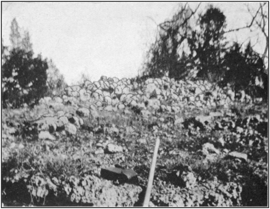
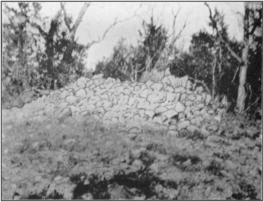
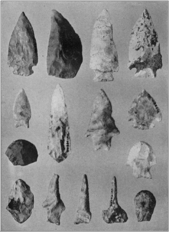
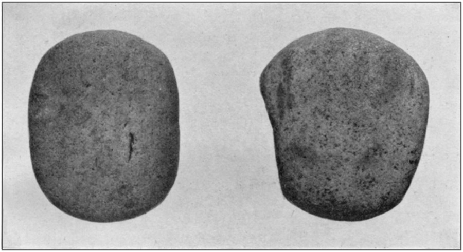
PLATE 16 A, Pestles or grinding stonesToList
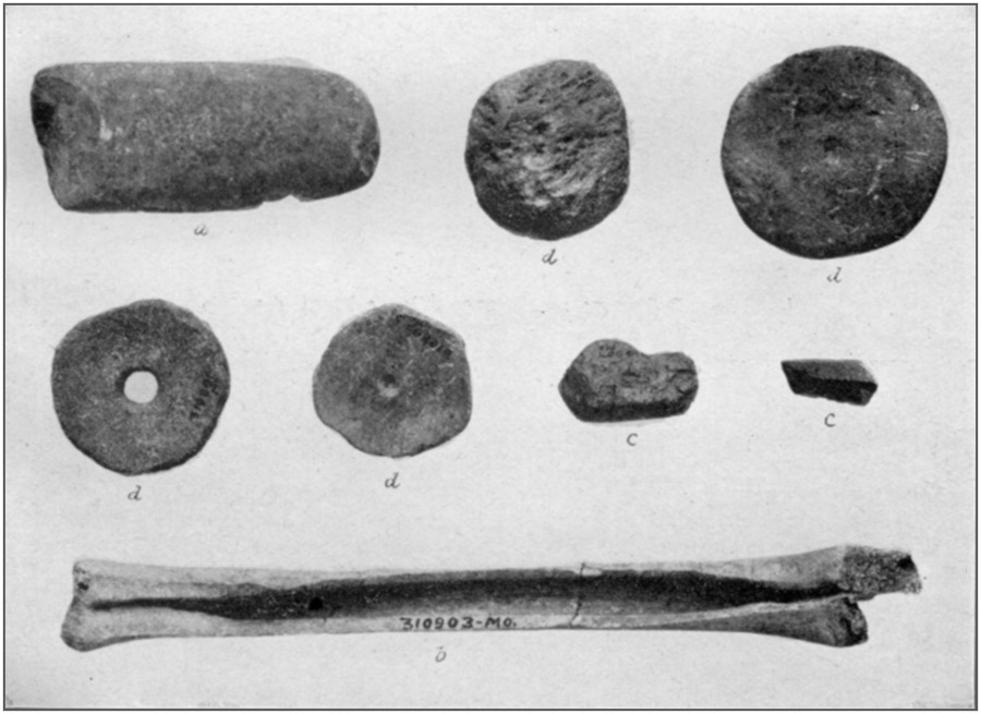
PLATE 16 B, Celt, pottery disks, paint stones, and skiver
OBJECTS FROM SELL CAVEToList
OBJECTS FROM SELL CAVEToList
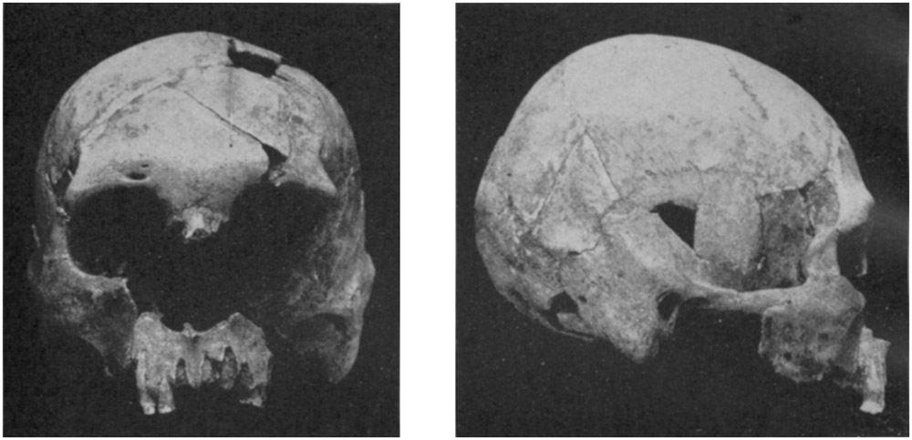
PLATE 17: Skull from Sell cave. a, Front; b, profile
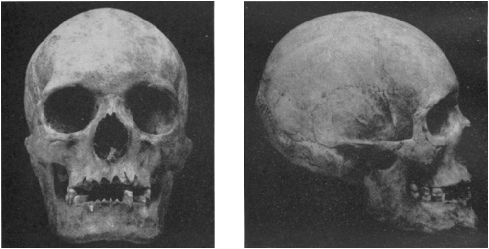
PLATE 17: Skull from Bell's cave, near Waynesville. c, Front; d, profile
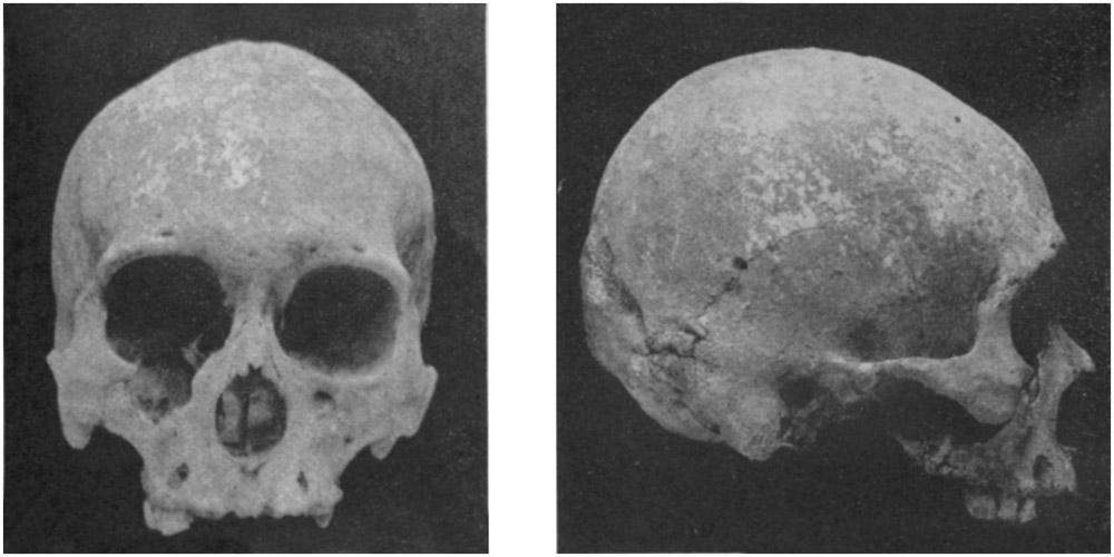
ToListPLATE 17: Skull from Miller's cave. e, Front; f, profile
THREE SKULLS FROM PULASKI COUNTY, MO.
THREE SKULLS FROM PULASKI COUNTY, MO.
If all this talus were examined, much material might be found, but the result would not justify the labor.
Fifteen feet west from the east corner of the cave, 8 feet within the edge of the roof, 3½ feet under the surface of the débris, which was a foot lower here than at the highest point, was a bundled or bunched skeleton; only small fragments of arm and leg bones, most of the lower jaw, a little of the upper jaw, and traces of skull were remaining. The bones were small but solid. They were packed tightly in the dark, wax-like clay, but there were no indications of a grave; the earth in contact with them could not be distinguished from that lying around them. The body had been crowded into the smallest possible space, with the head against a large stone. All the teeth were well preserved, some of them not at all worn. Small fragments of deer bones were found among the remains; these, also, were very soft and decayed.
In fact, all bones found, whether human or other, in this wet, tough, heavy earth were nearly destroyed, and such portions as remained had but little more consistency than the mud in which they were imbedded. Much care was necessary in order to get them out.
Sixteen feet from the entrance, 13 feet from the east wall, 4½ feet down, 18 inches above bottom, were part of a large femur and a few fragments of other bones too small and crushed to identify.
Seven feet southwest of this femur, 14 inches lower, was a closely folded skeleton, the skull nearly north, the other bones toward the east wall. Some mussel shells, fragments of deer bones, and two flint knives were near the head. The body had been placed in a shallow hole dug in the talus as it existed at that time, some earth thrown over it, and small rocks piled on. The covering rocks were under 3 feet of detritus, washed in since they were placed there. Near the knees was a piece of antler, neatly perforated, with rounded ends, giving it the shape of a reniform bannerstone (fig. 8). This may have been an ornament, an arrow-shaft straightener, or the holder for a drill or a fire-stick. Near it was a polishing stone deeply worn on both sides (fig. 9).
Twenty-two feet within the reentrant curve at the front, 20 feet from the west wall, at the bottom of the talus, was a skeleton, the skull in small fragments, which, however, were held in place by the tough clay. The teeth were worn below the enamel in places; two well-worked flint knives and one rough one (fig. 10) were near it. The bones looked as if they had been thrown in, occupying only a small space; but probably a folded body had been laid in on the left side.
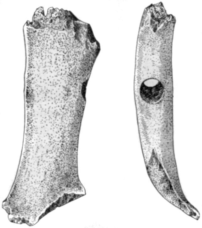
[48]At 24 feet from the entrance, 17 feet from the west wall, in a hole dug to 20 inches below the present surface of the talus, were broken and spongy bones of an adult. Pelvis, feet, and leg bones were in confusion; the tibiæ were reversed in position, but it may be that the body was laid on the back with the knees flexed and that the bones had fallen as they were found. This is probable, as each patella was where it belonged, and the body lay extended toward the southeast, as shown by the position of the skull. The humerus was about 12 inches long; all the bones were in small pieces. There were many mussel shells among and above the remains, over which earth and small rocks had been piled.
Two feet south of this skeleton and a few inches lower were the crushed and decayed bones of an old person with the head lying toward the east. The one tooth found (a molar) was worn entirely below the enamel except for a small space at the front; the dentine was polished until it resembled a piece of agate. Mr. De Lancey Gill first remarked the fact that wear of this character denotes that the individual did not gnaw bones, crack nuts, or indeed bite hard on any substance. If he had done so this thin shred of enamel would have broken off. Two large rocks which lay on the head and body seem to have been thus placed before the grave was filled with earth.
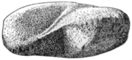
Near these bones were fragments indicating three other interments; the humerus of the last was perforated.
Other arm bones found showed the same olecranal perforation.
Twenty-one feet from the entrance, 19 feet from the east wall, was a skeleton, closely folded, on left side, head toward rear of cave. The teeth were worn flat. The bones were crushed by rocks laid on or above the body at the time of burial, as was the case with all the skeletons found in this part of the cave; probably timbers had been interposed.
Near the surface, 18 feet from the entrance, 14 feet from the east wall, were the right half of a skull and of a lower jaw; a few small, scattered pieces of skull were found near them. The teeth were [49]much worn, some of them were decayed, and two had the roots swollen and distorted by ulceration. South of the skull were fragments of feet and leg bones, probably belonging with it. This interment was of much later date than the others.
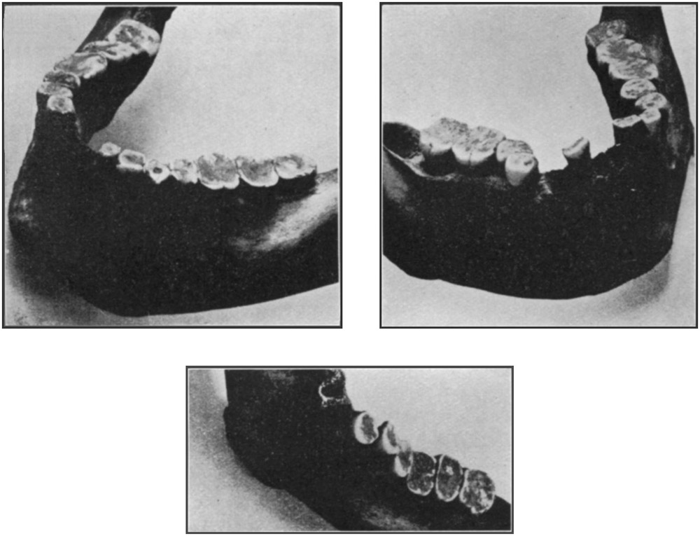

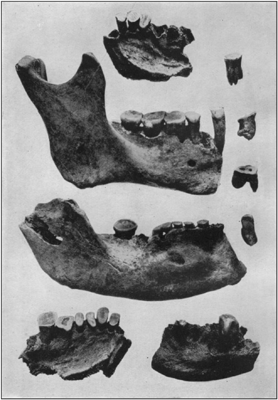
Thirty-two feet from the front, 16 feet from the east wall, 2½ feet below the surface, and a foot above the bottom of the talus, was a folded skeleton, on left side, head toward the interior of the cave, face directly upward. So much of the skull as could be recovered is shown in plate 17, a, b. The teeth were much worn, the bones broken, soft and spongy, falling away with the clay as it was removed from about them. The femur was about 17½ inches long.
Wear of teeth among aboriginal people does not of necessity denote a great age for the individual. Grit from ashes and fine sand from mortars and pestles will cut away the enamel to a much greater extent than would result from the use of ordinary food.
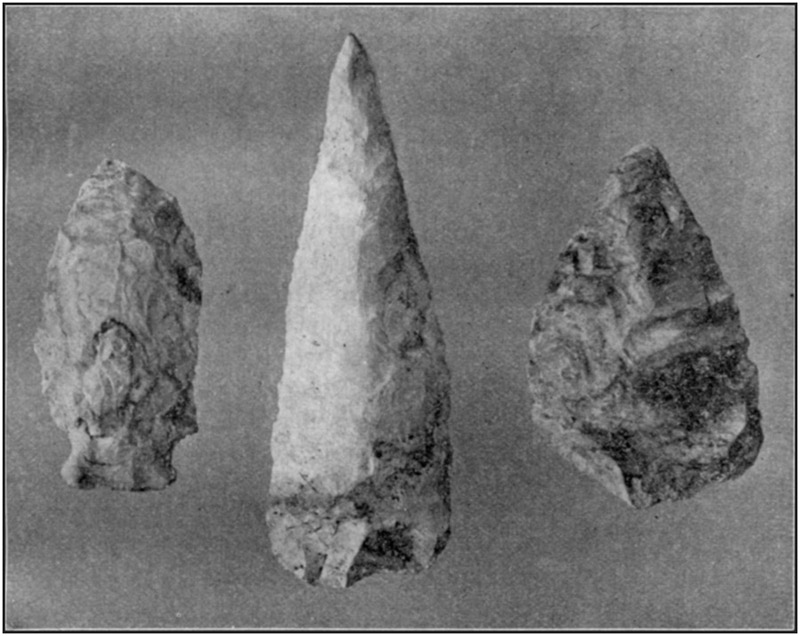
The condition of the teeth mentioned, as well as of some from other localities, is shown in plates 18 and 19.
From the inner end of the ditch, or runway, at the entrance the excavation was carried back for 40 feet in a direct line; or making allowance for passing around a massive rock which was in a position where it could not be blasted, for 43 feet; the depth of the talus here was 3 feet.
[50]On the east side the talus was removed to the wall, a distance of 28 feet from the edge of the trench, and the wall rock exposed for 22 feet, to the rear bank of the excavation.
All work, so far, had been carried on at a level a few inches below the bottom of the talus, which rested directly upon the floor of clay washed out from the interior of the cave.
Beginning next at the outer end of the trench, the entire space included in the first excavation was deepened by a little more than 6 feet, giving a new floor about 13 feet lower than the highest part of the talus. All the material thus removed showed that it was laid down by flowing water, sometimes so quiet as to deposit clay of impalpable fineness, sometimes with a velocity sufficient to carry stones weighing 3 or 4 pounds. The material varied—red clay, now jointed, was the topmost layer; below it, in patches and layers, were dark earth, resembling soil; clay of different shades of yellow, brown, red, and gray, sometimes almost blue; some of it uniform, some of it mingled, one or any or all of the different sorts in small compass; deposits of one sort filling sharply defined channels or potholes cut in some other sort; occasionally there was a slight admixture of sand. All included limestone pebbles, which were plentiful in some deposits but entirely absent from others, were weathered to a chalky consistency, the larger ones to a depth of perhaps half an inch, the smaller ones throughout. Scarcely any chert was included, although it is abundant on the hill; the few pieces seen were very small.It took five weeks of steady work, with two men, to clear out the second level. In all this clay there was not the slightest trace of bone or other indication that living beings of any kind had existed either in the cave or in any place from which the clay had come.
At 24 feet from the eastern side of the trench, projections on the face of the east wall denoted that bed rock was not far away. A hole 8 feet across, at the rear of the excavation, reached sand with a slight admixture of clay a few inches under the level at which the work was being conducted; and 4 feet down, or 17 feet from the top of the talus, the rock was found. It was rough and furrowed, like a solid stratum that has been long exposed to atmospheric weathering.
Further exploration was useless. The sand results from disintegration of the Roubidoux sandstone belonging next above the limestone in which the cave was formed. None of this remains on the hill; it has all been carried away by erosion. There is not now any sink hole or crevice above the level of the cavern through which the sand could have made its way. Such an opening must have existed at one time, on the slope at one side or the other, or farther back where the hill is now cut off. In either case, erosion has carried [51]away its walls and filled up the channel leading from it, and thus obliterated its site. To accomplish this would require a long time; enough to produce a considerable alteration in the topography, and so to predicate for the bottom deposits in the cave an antiquity far beyond the possible appearance of man in the region.
PHILLIPS CAVE
The Phillips Cave faces Roubidoux Creek near the Big Spring, a mile south of Waynesville. Access to the interior is possible only by crawling some distance on wet clay. Other caves in the same line of bluffs are either very small or almost inaccessible. No refuse appears about any of them.BELL'S CAVE (18)
In the upper part of the bluff bordering Roubidoux Creek just west of Waynesville, on the farm of Robert A. Bell, are numerous caves, most of them quite small. One, much larger than any of the others, has an entrance 27 feet wide and 12 feet high. The floor is of earth mingled with small rocks, and rises gradually toward the rear until at 70 feet it almost reaches the roof, although the open space enlarges farther in. The width of the cave varies from 19 to 32 feet. Several large rocks have fallen from the roof and walls at a comparatively recent date, as they lie directly upon the earth or are only slightly imbedded in it.Shells and flint flakes occur in small amount, but the cave is so difficult of access that it was probably but little used.
Some human bones, rooted out by hogs, were scattered over the floor; only a few remained, the hogs having chewed up most of them. Part of a femur belonged to a person about 18 or 20 years of age. A skull and part of a lower jaw, lying several feet apart but belonging to the same individual, were secured; they are shown in plate 17, c, d. Few of the teeth remained, though all had been in place at the time of interment.
CAMP-GROUND CAVE
This is three-fourths of a mile west from Waynesville. It is small, with a muddy bottom, and could never have been occupied.BUCHER CAVE
Bucher Cave is 2 miles northeast of Waynesville. It has a small, low entrance, nearly closed by a pile of chert gravel mixed with some clay, which has been carried by surface water from the slope above.[52]
GRAVES NEAR MCKENNAN'S
On a low spur, projecting about halfway up a high hill opposite McKennan's house, 2½ miles northeast of Waynesville, are two of the ordinary stone graves or cairns, both small. One has been torn apart; the other is intact.They are mentioned only because in the one which has not been disturbed the stones are sunken at the center, affording good evidence that timbers were placed over the corpse before the stones were piled up.
ROUBIDOUX CAVE (19)
In a vertical bluff overlooking the junction of Roubidoux Creek and the Gasconade River is a cavern with a high, wide entrance giving access to a large chamber which has several smaller but well-lighted rooms opening into it. There was formerly a considerable depth of earth on the rock bottom, but most of it has been taken out for fertilizer. What is left is dry near the entrance, but wet farther in. Although it would make an ideal Indian home, being easy of access and within a few rods of the two streams, there could be found no indications of such habitation; and owing to the small amount of earth remaining, the presence of many large rocks, and the close proximity of a large club house on the public highway immediately in front, no excavation is possible.A cairn on the point of the cliff over this cave has been completely demolished.
RICHLAND CAVE (20)
There is a large cave at the head of a ravine a fourth of a mile below the bridge over the Gasconade River, on the Richland and Hanna road, 7½ miles from Richland. The entrance is 70 feet wide and 40 feet high; daylight extends to a point 200 feet within, where the cave divides into two parts, both of which turn abruptly. Cave earth near the entrance on one side is scanty in quantity, damp and moldy; but beyond this it is dry, unevenly surfaced, and appears to have been somewhat disturbed. There is considerable refuse on and in the dry earth as far back as the inner end of the front chamber, and were it not for the many rocks, too large to be removed, which cover nearly the entire floor and would make excavation very difficult and incomplete, the deposits would probably repay investigation.ROLLINS CAVES (19)
On the farm of Sam T. Rollins, 2½ miles northwest of Waynesville, are two large caves.[53]The first, in a bluff facing the Gasconade, half a mile above the mouth of Roubidoux Creek, is 50 feet above the bottom of the hill. The entrance, toward the northeast, is 45 feet wide and 36 feet high. The sides are parallel for 45 feet; at that point the east wall abruptly recedes for 12 feet and then continues in a curving line for 120 feet farther, to an outlet in the side of a shallow ravine trending toward the west. This opening, 13 feet wide, is filled nearly to the top with débris which slopes steeply for 40 feet into the cave.
The west wall, at 45 feet, makes an outward curve to a branch which leads northwest for 25 feet and has an opening on the side of the hill 25 feet wide and 20 feet high; the talus at the front is 12 feet high and slopes steeply into the cave. Beyond this branch the west wall extends in a straight line to the small outlet at the ravine.
The floor of the cave has a gentle incline from the bottom of the débris in the rear to the main entrance.
No refuse could be found in the cave or around any of the three entrances; and the place would not be suitable for a shelter in winter as the wind, no matter from what direction, blows directly through it.
The second cave is near the foot of the hill, half a mile up the river from the first. A gentle slope in front leads to the bottom land along the stream. The entrance, toward the northwest, is 60 feet wide and 10 feet high. At 65 feet within is standing water; marks in a channel along the west wall show that at times there is an outflow with a depth of a foot or more. At the front is a great amount of talus partly fallen from the ledge forming the roof, partly washed down from the hillside; the outer slope is 20 feet high, the inner slope has a slight incline to the standing water. The entire deposit within the cave and in front of it is of tough, sticky clay. Many large rocks lie on the surface or slightly imbedded, and large trees grow on the talus. No indications of occupancy could be discovered.
MIX CAVE (21)
On the Mix farm, half a mile below the Gasconade bridge on the Waynesville and Crocker road, on the left (west) side, at the head of a ravine, is a cave with an entrance 75 feet wide and 20 feet high. Cave earth, apparently not more than 3 feet thick at any point, although it gradually rises to a level 6 feet higher than the floor at the mouth, extends back 80 feet; beyond this is water-soaked clay and gravel reaching 60 feet farther to a turn in the cave, making a distance of about 140 feet in daylight. There is a shallow channel 12 feet wide along the east wall from the gravel to the entrance; evidence that at times a volume of water of that width flows out of the cave. The cave earth is damp for several feet from the line of [54]its contact with the clay, a certain indication that its lower portion is saturated.Much refuse, including several mortars, is distributed over the floor, and it is especially apparent in the bed of the little stream; but fully half the surface is covered with rocks too large to be removed, and these, together with the water, will effectually prevent satisfactory excavation.
One of the mortars has a grinding cavity on one face 12 by 20 inches and 3 inches deep at the middle; on the other face, which has been pecked, apparently with a flint tool, to make it level and even, is also a cavity, but it is small and shallow, showing that this side of the stone was but little used.
DOUBLE CAVE (21)
On Walter Miller's farm, 1½ miles below the Crocker and Waynesville bridge, on the left side of the river, is the "Double Cave," so called for the reason that it has two entrances. The one farthest down the river is more nearly in line with the general trend of the cavern. Its opening is 35 feet wide and 20 feet high. At 40 feet in from the mouth, on the left or up-river side, the two parts of the cavern unite, a triangular partition of the original limestone strata separating them up to the point of junction. Across the apex of the triangle the main cave is 50 feet wide; there is no vertical wall on the right (east) side along this portion, the roof sloping down gradually until it meets the earth floor; it may extend farther, making the cave that much wider at the bedrock bottom. The cave earth at its highest point is fully 10 feet higher than at the entrance; but this may not mean that it is 10 feet deeper, for there are indications that the rock floor also rises from the entrance toward the interior. Digging in the front part of the main cave—that is, in the portion behind the lower entrance—would be impracticable owing to the huge rocks, some of them lying on the floor, others deeply imbedded in the earth; consequently part of them, at least, fell while the cave was inhabited.From the junction of the two branches the cave earth extends back 60 feet to clay and gravel washed down from the interior; there is ample light at this point, and for some distance beyond. In part, this gravel seems to overlie the loose earth; it is still depositing, and the manner in which the various materials intermingle and overlap at their meeting place indicates that the cave earth to some extent underlies the gravel and clay. This feature is worth investigating, as it might have a bearing upon the relative age of the cave deposits.
The entrance to the branch cave is 20 feet higher in the face of the bluff than that of the main cave, and consequently much above any water flowing from the interior; it is 20 feet wide by 15 feet high. [55]Measured along the east wall, it is 40 feet from this entrance to the apex of the triangle separating the two parts of the cavern. The greatest width of the united caves, 70 feet, is just beyond this point. The earth floor in the branch, a fine-grained yellow earth apparently deposited by quiet or gently flowing water, is 3 feet higher than it is at the highest point farther back in the cave, and is 4 feet or more higher than the bedrock at the front. No direct communication is possible, in front, from one entrance to the other. The only means of transference is by passing through the caverns around the triangular partition, or by going down to the talus from one opening and then up to the other; though only a few feet of descent is necessary. There is an easy passage to and from the Gasconade, which flows at the foot of the bluff; and a good path in either direction to the top of the hill.
Very little refuse occurs, and the site is not worth examining.
RAILROAD CAVE
On railway property, north of the Gasconade River on the east of the Waynesville and Crocker road, is a noted cave which "runs clear through the hill," and can be entered from either end. From the descriptions given it certainly could never have been utilized as a dwelling place.BAT, OR PAGE, CAVE
Bat Cave, so named because it formerly harbored immense numbers of bats, is on Robert Page's land, 4½ miles from Crocker, near the Waynesville road. The entrance is 40 feet wide and 30 feet high. Cave earth extends for more than 200 feet in plain daylight; at this depth the cave separates into two branches, one directly over the other. The lower division continues into the hill on a level; the upper rises at a slight angle; neither is high enough to permit a man to stand erect.The greatest width, a few rods from the front, is 55 feet. A drainage channel near one wall shows a considerable outflow in wet weather. In the low, vertical bank of this drain, gravel and small rocks are mingled with the earth in such quantity as to comprise more than half the mass. But this is probably due to the fact that a large quantity of earth, mostly, of course, from the upper part of the deposits, has been taken away for fertilizer. Neither in the bank of the little channel nor about the pits left by this digging is any refuse to be seen, and there is none about the entrance. So, in spite of its suitability for residential purposes and its favorable situation, it does not seem ever to have been utilized.
[56]
TUNNEL CAVE (22)
A fourth of a mile from the Bat Cave is a natural tunnel or underground passage which has its beginning in a deep sink hole half a mile away on the farther side of the hill. Into this depression pours all the water that comes through a ravine more than 4 miles long, receiving several tributaries on the way; thus draining several hundred acres of steep hillsides from which storm water runs off almost as quickly as from a roof. From the sink hole it passes into the upper end of the tunnel, an opening 10 feet high and 20 feet wide. Trash and drift around this inlet show that the water rises above its top.The lower opening of the tunnel is a beautiful, regular arch, 100 feet wide and 50 feet high. For some distance in, the interior is so choked with huge rocks, which reach almost to the roof near one side at the front, that it resembles a great quarry. Gravel, sand, and driftwood, including a large log 15 feet long, are piled on these rocks to a height of 20 feet.
BROOKS CAVE
Brooks Cave, 11 miles southeast of Waynesville, has an entrance through a sink hole in a level field. It is small and dark for some distance back, and was never occupied.Openings of this character are never the original mouths of caverns; they are due to the roof falling in at a point where it has become thin by wearing away from below.
RIDDLE CAVE
Riddle Cave is on John W. Schord's farm, near Wildwood. The entrance is through a sink, similar to that at Brooks Cave, and is due to the same causes. It could never have been occupied.LANE'S CAVE
Somewhat more than a mile north of Big Piney post office is a cave known as Lane's Cave. Near it is a smaller cave; also a rock shelter. They are all small, high up in the cliff, hard to reach, and unsuitable for living in.DRY CREEK CAVE
A cave on Dry Creek, north of Lane's Cave, is small and almost inaccessible. Never used.HOUSE MOUNDS (23)
There is a group of house mounds, about 100 in number, close to the site of the "Ranch House," which formerly stood near "The [57]Falls" 4 miles southwest from Big Piney. Two other groups, north of this one, carry the mounds for about 4 miles along a little valley, which extends north and south about midway between Big Piney and Bloodland. Most of the mounds, in all the groups, are on the slight slopes bordering either side of the little stream—which sometimes ceases to flow—but a few of them are on the narrow strip of level land along the banks.There is another group south of Bloodland. They were not learned of in time to visit them.
RIDEN'S CAVE
A mile southeast of the steel bridge across Big Piney, on the Edenville road, is Riden's Cave, in a small ravine opening into another ravine. The entrance is 25 feet wide and 8 feet high, and the front chamber extends 30 feet to an abrupt turn. There are large rocks on the floor near the mouth and some cave earth and a small amount of refuse at the front. Apparently it was never occupied except as a temporary camp.SALTPETER CAVE
Near Miller's Spring, 2½ miles northeast of Big Piney, in a high bluff, is a large cave whose name is derived from the quantity of saltpeter collected from it in the early settlement of the country. Earth for leaching was removed to such an extent that bedrock is now exposed near the entrance and at several places within. In addition many large rocks cumber the floor, consequently excavations would not yield satisfactory results, although refuse still to be seen in the cave and in front of it shows that it was a place of aboriginal habitation.MILLER'S CAVE (24)
Three miles northeast of Big Piney is a cavern which from its position, formation, and surroundings is particularly adapted to the requirements of primitive people in search of a permanent shelter. It is situated in a bluff rising from the left bank of Big Piney River, 200 feet above the level of that stream and half that distance below the summit of the hill of which the bluff forms the front. It lies in three different tracts of land, but the greater portion is on the farm of Daniel S. Miller, who lives a little more than half a mile away. For three generations it has been widely known as "Miller's Cave." It opens toward the southeast, the river at this point flowing north of east, and thus secures protection from the cold winds of winter, receives the greatest amount of light [58]through the day, and has the advantage of sunshine at the season when this is most needed. Big Piney, like all streams in the Ozark region, is extremely crooked and its bed is a continuous succession of riffles and pools, or eddies as they are locally known. In front of the cave is one of these pools nearly a mile long and at lowest stages fully 15 feet deep in places; even now it yields an abundance of fish, turtles, frogs, and mussels, all of which are important items in the aboriginal dietary.A fourth of a mile above the cave Big Piney makes an abrupt turn, coming to this point from the southeast. Here it receives the outflow from a large spring located at the foot of the hill, a fourth of a mile to the southward, which boils up in a pool 40 feet across and at its lowest stage discharges several thousand gallons every hour. Its volume responds quickly to a heavy rainfall and to the succeeding period of fair weather, although its level never passes above or below certain fixed points. A singular feature of this spring, one which has given it a wide reputation, is its rhythmic ebb and flow. With absolute regularity, regardless of atmospheric conditions, it swells for six hours, then subsides for an equal period, stages of high and low water occurring at the same hours every day. The extreme range of level is about a foot. Intermittent springs are not uncommon; but the regularity of this one is remarkable, particularly so as its action is not affected by changes in the volume. A dam was built below this spring by the father of Mr. Miller to furnish power for a mill; when the mill was not running the noise of the falling water, reenforced by the echoes from the hills around, could be heard a long distance and gave it the title of Roaring Spring. The Indians had a name for it which was interpreted by the whites as "Blowing Spring;" but as there are no unusual currents of air in the vicinity it is probable the proper translation would be "Breathing Spring," on account of its recurrent motion. The branch from this spring, following a course along the foot of the hill, is wide and shallow, though swift, and is nearly filled with a dense growth of long, moss-like vegetation which was greedily devoured by deer, herds of them being frequently seen in the water by early settlers.
From the mouth of the cave several hundred acres of fertile alluvial land can be seen along both banks of the river. In the bottom land lying nearest to the spring branch—which is itself entitled to be called a creek—and extending southward to Miller's residence, partly on an upper terrace, but mostly on the low land, was a village site on which were formerly many small mounds which from the description were undoubtedly house mounds. Mortars occur in numbers, while fragments of pottery and flint, as well as many unbroken implements, were formerly abundant to a depth of several [59]inches. On the opposite side from the cavern, in the angle formed by the abrupt turn of the river, is another village site. A ditch, with an interior embankment about 6 feet high, formerly extended in a curved line across the point. This fortification was about 600 feet long, coming to the river bank at either end. In the part thus protected were many low, small mounds placed close together but quite irregularly. These were probably house mounds. No trace of any of this artificial work is now apparent except that a difference in color may be seen here and there when the soil is freshly turned, all the earthworks having been plowed and dragged level as interfering with cultivation. A great amount of broken pottery, flint implements, and fragments of animal bones has been uncovered here. In fact, the field is known locally as "the place where the Indians made their pottery." This site seems to have been occupied within historic times; after an unusual freshet some years ago, many "round musket-balls, such as belonged to the old-fashioned muzzle loaders"—"hundreds," or "two gallons," of them is the usual version—were picked up where the loose soil had washed off. There is a local tradition, long antedating the discovery of the bullets, that a "battle" was fought here between the French and the Indians.
On the hill over the cave are three cairns, but they have been so searched through that scarcely a stone remains in its proper place. There is also the site of a flint-working industry, a space 40 or 50 feet across being strewn with spalls, flakes, and chips.
When, in addition to the sustenance provided by deer and other large game, there is taken into consideration the great numbers of wild fowls which frequented the rugged hills and numerous streams; the multitude of small mammals which found security in the myriad cavities and crevices in the cliffs; the abundant food supply in the river; and the further fact that so many mortars and pestles meant the utilization of nuts and the cultivation of corn and no doubt of other foodstuffs as well; it is apparent that the problem of mere subsistence was one with which the natives had but little need to concern themselves. That full recognition was accorded to these advantages is amply attested by the great quantity of flints found everywhere in the vicinity, the numerous workshops on the hills and in the bottoms where the ground is thickly strewn with débris in every stage from the intact nodule or block to the finished implement, and the amount of refuse not only in this cavern, but in the Saltpeter Cave in the same bluff and in the Freeman or Ramsey Cave 3 miles down the river on the opposite side. Miller's Cave, however, possesses an additional advantage, one probably not to be found elsewhere. This is the absolute security of its inmates from the attack of an enemy. The mouth of the cave is in the face of a perpendicular bluff, the [60]wall on either side so smooth that not even a squirrel can obtain a foothold. The upper stratum of the precipice projects to such an extent that a rope or a ladder let down from above would fall several feet beyond the outer edge of the floor. Below, there is a vertical drop of 30 feet to the top of the rough talus which is as steep as rocks and earth will lie. If an assailant, by approaching from either side, should reach the foot of this bluff he would offer a fair target for stones rolled or hurled down by defenders who are safely out of reach of missiles from any direction.
The only means of entrance is a small opening in the west wall, communicating with another cave. This is so restricted in size as to permit the passage of only one person at a time, and he must assume a crawling or crouching posture. This opening, which for distinction will be called the doorway, has its top, sides, and bottom coated with stalagmite formation; so it may once have been somewhat larger than at present. The limited amount of the deposit over the natural rock at either end of the orifice is evidence, however, that it could never have been high enough for a man to walk through without stooping, or wide enough for two persons to pass each other; consequently one man armed with a club or other weapon could easily guard it against any number who might attempt to enter.
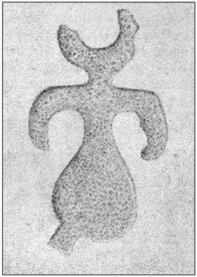
The cavern from which this opening leads, and which will be called the outer cave, is close to and nearly parallel with the face of the bluff, and its course is therefore approximately east and west, forming nearly a right angle with the main cavern. It has a slight curve, so that the doorway is not visible to one who is approaching from the outside until he is within a few yards of it.
The outer cave has its beginning at a point where the bluff bends toward the north; that is, where there is a shallow reentrant curve, formed by the face of the cliff breaking away at this part and rolling down the hill; a considerable portion of this cave itself has been thus destroyed, as shown by another entrance into the bluff beyond. Much talus has accumulated in this cave, over which there is at present a fairly easy though winding and zigzag path to the entrance from the top of the hill, and a rough and difficult way from the bottom. It is a natural presumption that dwellers in the cavern had well-constructed though necessarily devious pathways of easy grade to both the top and the bottom of the hill; but owing to the loose nature of the débris on the outside slopes all trace of these, when abandoned or no longer kept in repair, would soon be obliterated by surface wash, landslides, and the roots of trees.
By the side of the upper trail, at the bottom of the sandstone ledge capping the hill, are many large blocks which have split off from this stratum. On the flat surface of two of these are about 25 figures, pecked into the stone apparently with a pointed flint implement. One [61]of them measuring 6½ by 30 inches, shown in figure 11, bears some resemblance to a flying bird. All the others are of uniform design, an oval or elliptical figure with a straight line or bar passing through an opening in one end. These vary from 4 to 18 inches in length; two of them are shown in figure 12. Owing to the rough weathering of the stones accurate tracings were not possible, but the illustrations give a fairly correct idea of the inscriptions as they originally appeared.
The front part of the outer cave is partially filled with large rocks, gravel, and clay, which have fallen or been washed in. A window-like opening on the right, or south, side admits additional light. Near the inner end the cave divides, one branch going to the southeast and opening in the face of the bluff, the other turning north and terminating abruptly near the doorway, which is worn through its rear wall. A rough diagram (fig. 13) with some measurements is appended to show this cavern's peculiar structure.
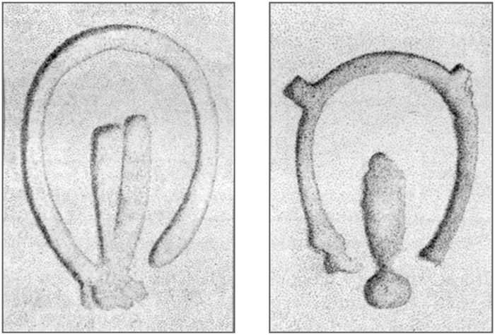
| Feet. | |
| Width at mouth (A) | 17 |
| From mouth to "window" (B) | 21 |
| Width of window (B), which has a very irregular outline | 3 |
| [62]From window to where cave divides (C) | 39 |
| From corner of divide (c) to opposite corner (H) | 13 |
| From corner (H) to rear wall | 11 |
| Greatest width, from (B) to (F) | 22 |
| Width from (C) to (G) | 10 |
| From north wall near (G) to face of bluff (D) | 28 |
| Height at mouth from talus to roof | 8 |
| Height from floor to roof between (C) and (G) | 13 |
| Lowest point in the cave (near C), below entrance (A) | 7 |
| Mouth, at (D), lower than floor at (C) | 4 |
A small amount of refuse on the floor suggested use of the outer cave for residence or shelter; but excavations at several points uncovered bedrock, with very irregular surface, at depths of 6 inches to 2 feet, the earth containing very little refuse and no ashes. On the talus at the entrance, and also at the bottom of the bluff in which the caves open, is much refuse which the inmates threw out as rubbish.
The front chamber of the main cavern is quite regular in form, going straight back like a vault for 80 feet, then turning abruptly westward with a width of 47 feet, the west wall making almost a right angle at the corner. The east wall abuts squarely against the rear; a narrow crevice leads eastward from their junction, but as this was filled with water and mud no exploration in it was attempted.
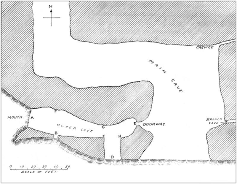
[63]The floor of the front chamber, from wall to wall, and from near the front to within 27 feet of the rear, was entirely of ashes, no earth being visible until the extremity of these at either end was reached. The floor of the western extension is covered with fine earth, washed in, which gradually increases in volume until it fills the cave to within a foot of the roof. It was not examined beyond this point.
Measurements show these dimensions:
| Width of cave at mouth | feet | 64 | |
| Least width of cave, 24 feet from mouth | do | 45 | |
| Greatest width of cave, from doorway to branch in cave in eastern wall | feet | 74 | |
| Shortest distance from line of least width to line of greatest width, as given above | feet | 18 | |
| From mouth of cave to doorway | do | 51 | |
| Height of doorway | inches | 42 | |
| Width of doorway | do | 33 | |
| Length of floor of doorway | do | 56 | § |
| From mouth of cave to top of slope of ashes at rear | feet | 84 | |
| From top to bottom of slope of ashes at rear | do | 16 | |
| From foot of ash slope to rear wall | do | 27 | |
| Extent of ashes in turn of cave along foot of wall beyond corner of west wall | feet | 22 | |
| Width of these ashes, from foot of wall to the pool of water | do | 22 | |
| Width of cave from corner of west wall to east wall | do | 56 | |
| From corner of west wall to rear of cave | do | 47 | |
| Height of extreme front from floor at edge of bluff to most projecting ledge above | feet | 35 | |
| Height from shelf or ledge near front of east wall to general level of roof | feet | 14 | |
| Height from ashes to roof at middle of cave | do | 10 | |
| § This measure also represents the thinnest portion of the wall separating the main cave from the outer cave. | |||
The walls were, as is usual in caverns, somewhat irregular, there being a narrow bench or shelf along each side near the front, while projections and indentations alternated from front to rear. There were numerous small holes and crevices, enlargements of seams and joints by percolating water at an early stage in the cave's history. These furnish homes for various wild animals, and nearly all of them contain bones, sticks, and trash taken in by ground hogs and wood rats which seem to find much pleasure in carrying such things from place to place.
The work of excavation began at the extreme front of the cave, where the original bottom, a mixture of sand, clay, and chert gravel, had been exposed through removal of the ashes by winds and driving rain. Almost immediately rocks, large and small, fallen from walls and roof, were encountered and interfered greatly with the digging. In the upper foot of the clay were streaks of sand and ashes, among [64]which a mussel shell and a flint chip were found; and the top of the clay was quite uneven, appearing as if carried and thrown here, as perhaps some of it was early in the occupancy of the cave, with the object of making a more even or level floor farther back. But this admixture was only superficial; below it, the material had all the appearance of a running water deposit.
A ledge extended along the east wall for 40 feet, with a width of 12 to 14 feet; at the inner end it was about 4 feet below the general level of the floor. At 8 feet below its top a second ledge projected from it, sloping toward the center, slightly for 8 feet then more rapidly for 10 feet farther, where it merged into the bedrock. Then came level, nearly smooth rock for 18 feet, to the foot of the slope of the west wall, 14 feet out from that side of the cave. This was probably the original drainage channel.
By the gradual erosion of new channels through the limestone and the consequent abandonment of old ones, subterranean drainage is continually altering its direction and force. In this way caverns may be left entirely dry, with bare floors; or may, especially if they receive the drainage of sink holes, be partially or even entirely filled with débris thus carried in. Like others, Miller's Cave has undergone such changes. It was begun by clear water; enlarged by erosion and by breaking down of walls and roof; presently clay, sand, and gravel were carried in; finally the water no longer flowed through the front, but found its way out in some other direction. In time the deposits became sufficiently dry to afford a good site for camps and for permanent occupation. There is no way of ascertaining the rate at which these changes took place; it may have required many centuries to make an appreciable difference in appearance; or, on the other hand, the transition from one stage to the next may have been rapid.
Along the foot of the ledge from the east wall the clay was only a few inches deep; farther out on the ledge, and on the projection extending from it, were layers of red sand. Occasionally a small patch of it appeared along the western side. Probably it was washed in among the last of the natural deposits.
There was considerable chert gravel mixed with the clay, making excavation as difficult and laborious as digging up an old, much-traveled macadamized highway.
The surface of the ashes sloped upward rather rapidly for a distance of 29 feet from the front. Kitchen refuse, found in them from the start, contained many mussel shells; bones, including those of bear, deer, panther, turkey, and other large fowls, tortoise, turtle, fish, and various small mammals and birds; potsherds; broken flints, with the débris of chipping work; mortars, pestles, hammers, and mullers. Near the west wall, 14 feet from the mouth, imbedded in [65]the ashes and a foot below their surface, was a well-preserved cranium, shown in plate 17, e, f. There were no other bones, not even the lower jaw; it seems to have been thrown here and covered with the dumped ashes.
At 18 feet from the mouth the rocks became larger and so numerous as to be almost in contact, projecting above the ashes and imbedded in the clay down to bedrock; they extended for 22 feet farther in and to within 14 feet of the west wall. The clay attained its highest level at the beginning of this pile of rocks, having an elevation of 9 feet above bedrock; it became lower toward the interior, with its surface everywhere rough and irregular.
The rocks were too large to be either moved or broken up, and owing to the condition of the roof an attempt to reduce them by blasting would have been attended with great danger, so they were perforce left in place and as much as possible of the clay between and under them dug away. Beyond those near the front, others, not reaching the top, were found one after another buried in the clay; owing to their constantly increasing number, and to the inward slope of the east wall, the limits of the excavation gradually narrowed, hampering the movements of the workmen, and it was necessary to handle the earth two or even three times to get it out of the way. There was growing risk, too, of the projecting rocks splitting off or breaking out of the clay matrix. As some of them weighed several tons, the danger became too imminent, and efforts to continue along the bedrock had to cease.
Two other attempts were made to get to the bottom; one at 40 feet from the mouth just beyond the large rocks on the surface, and one at 15 feet farther in. The last one started on an area 8 by 15 feet, which would have been ample if the sides could have been carried down even approximately straight. Neither of these efforts met with success, for the same reason that led to the abandonment of the first one.
From here to the end, examinations were confined to the deposit of ashes. The surface, except as it had been disturbed by relic hunters, was practically level from wall to wall, but the depth varied with the undulating top of the clay beneath. Where it was deepest, in the central portion about 50 to 75 feet from the mouth, the deposit had a thickness of 6 feet. From this it diminished to about 3 feet on the sides, with an occasional thinner patch on a narrow shelf formed by a ledge or a crevice. The average thickness was close to 4½ feet, so the amount was not far from 800 cubic yards. This was composed entirely of ashes from small fires for cooking, heating, and lighting purposes, increased to a very limited extent by kitchen waste, and by discarded or mislaid wrought objects. It represented the combustion of many hundreds, perhaps of thousands, [66]of cords of wood, all of which had to be carried in from the hilltop or slopes and passed through the constricted doorway. This labor would be a sufficient guarantee of economical use; we may be sure that no fuel was wasted. If proof were needed of such a self-evident proposition, it would be found in the almost complete absence of charcoal; here and there, but seldom, a small mass of it showed that a burning chunk, covered up, had smoldered until the inflammable portion was consumed. Bunches or handfuls of coarse grass or small weeds had undergone the same process. Perhaps these had been used as kindling.
In all the deeper parts the ashes had been dumped promiscuously, from fires made at other points; no camping fires seem to have been made along the middle of the cave until the depressions in the clay had been at least partially filled. The ashes in the upper 4 feet of the ash beds where these were deepest, and in nearly all the shallower portions, were stratified and usually level, though at the front and rear the strata followed the natural incline of the slopes. The first impression was that the ashes had been carefully spread out, or dragged, to make their surface even; but it was discovered, when shoveling some of them for the second time, that ashes may assume this appearance no matter how carelessly thrown. The ashes at the top, to a depth of 3 or 4 inches, were as fine as flour, and when shoveled back hung in clouds for hours at a time, to the great discomfort of the excavators, whose eyes, throats, and nasal passages were in a state of constant irritation. The stratified or laminated, hard-packed condition below the loose surface means, perhaps, that they were occasionally sprinkled and trampled by the occupants to prevent this trouble. Possibly they were covered with mats, skins, weeds, or leaves, in the parts where the inmates congregated. The loose, incoherent condition of the lower portions, which "shoveled like snow," may denote that only a few persons dwelt here at first, who found ample room on the higher ground near the doorway. However, all such attempts at explanations are not much better than mere guesswork, and we must be content with accepting the facts as we find them.
Where the ashes were white and packed hard, whether on the site of a fire or in thin layers where thrown, they contained very little extraneous material; whereas in the darker, more mixed material broken bones, potsherds, shells, and other refuse were abundant, while there was scarcely a cubic foot anywhere in which was not found a piece of flint or bone, sometimes several such objects, which had been intentionally altered from their natural condition.
Near the center of the cave was a curving pile, 6 by 2 feet, and several inches thick, of mussel shells of every size from less than an inch to above 5 inches in length; more than half of them were [67]over 3 inches. None of them showed any marks of fire; some had both valves in position, as if they had never been opened, and a few of the larger of these had been filled with small shells and closed again. A few were broken, but most of them were entire. About 1,400 valves were in this pile, meaning that at least one-half of that number of mollusks were consumed.
The first interment was found at 46 feet from the front, 14 feet from the east wall. The folded skeleton of a very old person lay on the right side, head east, in loose ashes, on a large flat rock whose top was 30 inches below the surface. This rock had not been placed here, but had fallen from the ceiling; probably its existence was not known until it was uncovered in digging the grave. The skull still retained its shape, in part, being held in place by the ashes, but fell in pieces when this support was removed. A portion of it was gone; two fragments were found, several feet away, not near each other, one of which fits in the skull, and the other probably belongs with it also. The frontal bone is nearly half an inch thick; the sutures partially obliterated; the teeth worn down to the necks, some of them nearly to the bone; the forehead is low and receding. A restoration is seen in plate 20, a, b. In addition to the missing portions of the skull, most of the ribs, half of the lower jaw, and nearly all the dorsal vertebræ were absent, probably having been dragged away by ground hogs. The bones are all light and fragile. Lying above the skull, in contact with it but supported by the ashes on both sides, was half of a large mortar hollowed on both sides. Above the skeleton, and extending for several feet on every side, was an undisturbed stratum of closely packed ashes, 17 inches thick at the middle, which broke off under the pick in large clods; these, of course, had accumulated after the body was interred.
The spongy condition of these bones, in spite of the preservative action of the ashes, is evidence of the fact frequently noted, that with advancing age some change takes place which renders them less resistant to destructive influences. Bones of children only a few weeks old near this skeleton held their structure perfectly and were easily secured.
Ten feet east from the pile of mussel shells, at a slightly lower level, was nearly half a gallon of snail shells which had been boiled, probably in soup. With them were a few pieces of bones.
Scattered irregularly through the ashes were many cavities which somewhat resembled the "postholes" so common beneath the mounds in Ohio. Some were barely an inch in diameter and a foot deep; from this size they varied indefinitely to the largest, which was a little more than 3 feet deep, reaching from about a foot below the undisturbed layers just under the loose surface ashes to within about [68]a foot of the bottom. "About" is used advisedly, because at this point neither the top nor the bottom of undisturbed material could be determined with certainty. The lower 2 feet of this cavity was uniformly 7 inches across; above this it slightly expanded, funnel-like, to a diameter of 8 inches at the top. The sides of this, as of all of them, large or small, were as smooth and hard as if made with a posthole digger or a boring tool. Strata of ashes, not changing their level or appearance in the least, were continuous around the margin. But the holes were not always straight; some of them changed direction as if due to a crooked post or stick. Nearly all of them were rounded, even hemispherical at top or bottom, or both, like the bottom of a pot. They were not molds, for nothing could have been taken out of them without changing or destroying its form. If they had contained any solid substance like a post it must have stood unchanged until the layers of ashes surrounded and covered it, and then must have so completely disappeared as to leave no trace of its existence. They were not formed by driving any object down, because in that case the bottom would not have been so regularly rounded and the ashes around the sides would have been more or less displaced. They were not due to burrowing animals. In fact, if there be imagined a nearly cylindrical mass of ice, straight or slightly crooked, with rounded ends, placed upright and retaining its position unmelted until completely buried, the appearance of these cavities will best be understood. Some of them were filled to the top with fine loose ashes which occasionally contained fragments of bone, shell, and pottery; sometimes they were nearly empty, with traces of decayed wood at the bottom, mingled with a little ashes and charcoal. In one was found a long, perfect bone perforator, shown at a in plate 30; in another near the corner of the west wall was found the pipe shown in figure 14. About 45 feet from the front near the east wall were four of them of different diameters and depths but all in a straight line within a space 2 feet long; these were in front of a crevice under an overhanging ledge where a man could not stand upright. Wigwams may have been erected in the cave, or at least skins stretched to prevent drafts or to confine the heat of fires in winter and perhaps to insure some degree of privacy if this were desired; but there are no present indications of such shelters unless these holes were to secure them; otherwise their purpose or object is still unsolved. They would probably not contain posts for hanging things on when the walls afforded so many small crevices and holes into which poles better adapted for such purposes could be thrust.
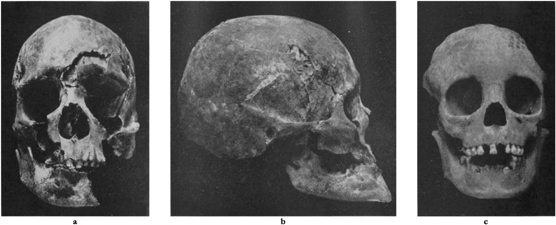
PLATE 20
a, b, Skull from Miller's Cave, Pulaski County, Mo. (a, front; b, profile).
c, Part of skull of child from Miller's cave (front view)ToList
a, b, Skull from Miller's Cave, Pulaski County, Mo. (a, front; b, profile).
c, Part of skull of child from Miller's cave (front view)ToList
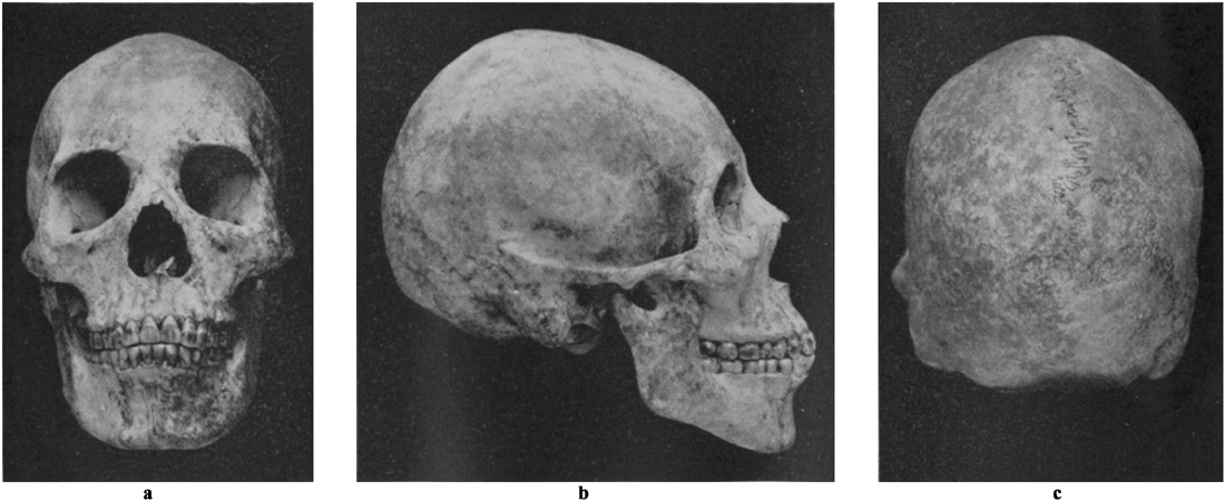
About the middle of the cave a saucer-shaped depression, 4 feet across and 10 inches deep at the center, had been dug in the red clay; ashes had been deposited to a depth of 2 feet over this space before the excavation of the hole was begun, and streaks of red clay lay at about this level all around the pit. Many rocks, large and small, apparently thrown in, were in this basin and above it. No fire had been made in it; nothing buried; and the upper layers of ashes extended across it unbroken. It forms another of the unsolved problems.
In the den of a burrowing animal smaller than a ground hog was the frontal bone and upper portion of the face of a child of 8 or 10 years; 12 teeth are cut and others can be seen. It is shown in plate 20, c. Part of a cervical vertebra lay at the top of the skull, and there were fragments of a few other bones.
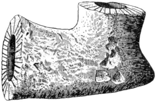
The ulna of a child, broken off at the wrist, was near the doorway in a mass of refuse in a ground-hog burrow. For several feet in every direction around here the ashes were traversed by the tunnels and dens of these animals, some of them extending down into the clay.
Twenty-five feet east of the doorway, a foot below the highest layer of unbroken ashes, was the top and back of a thin skull.
Sixty feet from the front, 15 feet from the east wall, at a depth of 14 inches, was a partial skeleton, lying on the back. The right arm, folded, lay by the side; the left forearm across the pelvis. All bones from the atlas to the sacrum, except some bones of the hands and wrists and the left ulna, lay in such position as to show they had been interred with the flesh on, or at least while the cartilages [70]held them together; but no trace of the skull—which had lain toward the west—or of any part of the legs or feet was present. Fragments of coarse cloth were adhering to the pelvis. The bones, which were almost like punk, were those of a young person, the caps of the long bones being separate from the shafts; but they were of good size, the humerus being 13 inches long. The left ulna (at least a left ulna) lay above where the face should have been, but some inches away, with one end near the surface. It is quite probable that ground hogs are responsible for the condition of this skeleton, and that some of the bones found scattered in the ashes belonged to it. About a foot under the bones, but not connected with the burial in any way, were three large pieces of a large pot.
Four feet east of this, a foot lower, was the skeleton of a baby, the humerus only 3½ inches long. The bones rolled out with some loose ashes, and not all of them could be recovered.
Thirteen feet from the east wall, 16 feet from top of rear slope of the ashes, 4 feet below the surface was part of a skeleton. The bones lay on a damp, close-packed bed of ashes 6 inches thick. They were closely folded, the femurs and lower leg bones being in contact; the skull, scapulæ, right humerus, sacrum, and some of the vertebræ were missing. Such bones as remained were in their proper positions, except that the sternum lay in the pelvis and the elbows at the knees. All of them were in a space only 18 by 22 inches, measuring to the outermost points. The situation of such bones as remained indicated that part of a skeleton had been buried after the flesh had decayed, or had been removed, but while the joints were still united, and covered with loose ashes, whose settling had caused some sagging of the stratified ashes, a foot in thickness, which lay above them, there being no evidence that they had been disturbed since they were placed here. All were as light as cork and, except the left tibia, which was 15½ inches long, fell to pieces when taken up.
Eight feet east from the last skeleton was one of a very young infant, on left side, head toward the front of the cave. It was 2½ feet below the surface, partly under a jutting portion of a large rock whose top was above the ashes. It lay on small angular rocks, with similar rocks over it.
Two feet west of this was the ulna of a child 10 years old.
Sixteen feet from the east wall, 10 feet from top of rear slope, 2 feet under surface was another infant's skeleton, lying on the back, head toward the mouth of the cave. The femur was only 4½ inches long.
Fifteen feet from east wall, 8 feet from top of rear slope of ashes, a little more than a foot below the surface, was the closely folded skeleton of a woman between 20 and 25 years of age. It lay on the right side, with the head east. The bones were in perfect condition, [71]even the coccyx being intact. All the teeth were present, solid, and symmetrically set. Unbroken strata of ashes a foot thick above this skeleton sagged somewhat owing to settling of loose ashes thrown around and over the body at time of burial. The skull is shown, front, profile, and back, in plate 21.
A few inches below these bones, with ashes intervening, were piled some bones of a child of about 8 years. The caps of the joints were not adherent, and some of the teeth had not come through the bone. The skull, which was intact, lay on left side, vertex north, ribs, arm bones, and feet bones lay on the top, at the back, and at the vertex, in contact with the skull and with one another. As there was no evidence that they had ever been disturbed by animals, it would appear that only the bones mentioned had been deposited; even the lower jaw was absent. They lay in a mass of kitchen refuse, shells, burned bones, charcoal, and ashes, the upper layers of which were curved as if the bones had been laid on a level area of this mixed material and the rest of it piled over them. Their position, and the small number of them, indicates that the flesh had been used as food. The skull is shown in plate 22.
Between this partial skeleton and the complete one above it, apparently thrown in with the refuse which covered and surrounded both, were fragments of two large pelvic bones which did not belong to either of them.
Directly below these burials, 3 feet under the surface, was part of an infant's skeleton, with five shell disk beads among the bones; the only instance in which ornaments were found with human bones. The skull and some other bones were present, but most of the remains had disappeared into the runway of a burrower.
At several places in the central parts of the cavern, at almost any level between the top and the bottom of the ashes, were human bones, singly or a few together, some of them apparently remains of interments, others carried to the points where found. Most of these scattered bones were of children or infants; but now and then larger ones were found, notably two large adult tibiæ which were a foot apart. While a few of them may have been thrown in with the ashes, most of this confusion resulted from the activity of rodents, though some of it was due to desultory former investigations.
At one point was the perfect lower jaw of a child 8 or 10 years old; with it were a scapula and some vertebræ which may have belonged to it, also some ribs, vertebræ, and arm bones of an infant. Two or three of them bore marks of fire, especially an ulna of a child which was completely charred.
Four feet from east wall, 4 feet below surface, at the beginning of the slope to the rear, was the skeleton of a child less than 2 years [72]old. It lay on left side, head east, legs bent, one arm folded with hand by head, the other along the body; just such a position as would be assumed by a sleeping infant. Some of the teeth were cut. All the bones were in place, though soft and brittle; above them was an unbroken stratum of ashes.
Four feet west of this, 2 feet higher, was the skeleton of a still younger child.
Sixteen feet from east wall, at the beginning of slope to rear, near the bottom of the ashes, was an adult's skeleton, extended on back, head west. Three rocks, weighing from 75 to 300 pounds, were placed over the body. Most of the bones had disappeared from decay; the middle third of one tibia was much enlarged by disease, as shown in plate 23.
Eleven feet east of this, 4 feet below surface, was an adult skeleton, folded, on right side, head toward rear of the cave. The bones were spongy and soft. Portions of the feet and legs, most of the pelvis, the left arm, and some of the vertebræ were present, but there was no trace of right arm, skull, or shoulders. A slab weighing 100 pounds or more was set on edge just where the head should have been. One tibia, the only bone with both ends remaining, measured 14½ inches.
Near the wall, just beyond the break of the slope, was the entire skeleton of a dog so old that its teeth were rounded and smooth. It had been killed by a spear thrust entirely through its body, from the right side, both scapulæ being penetrated; the holes are three-fourths of an inch in diameter. The skull of a fox was found near this, higher in the ashes.
Fifteen feet from east wall, halfway down the slope, 18 inches under surface, was the skeleton of an infant only a few days old. No trace of pelvis or right leg remained, though all the other bones were well preserved.
Twenty-four feet from east wall, at beginning of rear slope, was the complete skeleton of a young child, extended, on back, head toward rear of cave. The bones showed evidence of disease, as may be seen in plate 23. The skull is shown in plate 24.
Nineteen feet from east wall, 13 feet from foot of slope, was a hole 4½ inches to 5 inches in diameter, 21 inches deep, extending into the loose dark earth underlying the ashes. The bottom of the hole was muddy, being at about the level of the standing water, and contained charred and decayed remains of oak wood. Ashes, in layers having the same slope as the surface, extended over it, proving the post (?) to have been burned some time before the cave was abandoned.
West of the doorway a ledge, projecting from 4 to 6 feet, extended to the west corner. It was covered 2 feet deep, or less, with ashes containing the usual refuse. Large rocks lay on this, or had fallen [73]over it to the clay lying against its lower part, or into the ashes on the clay.
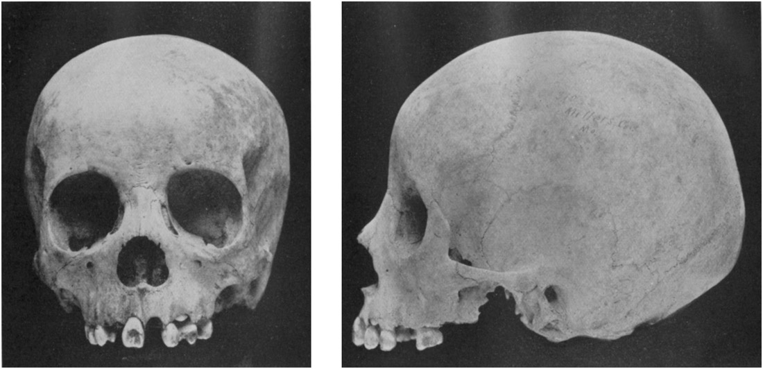
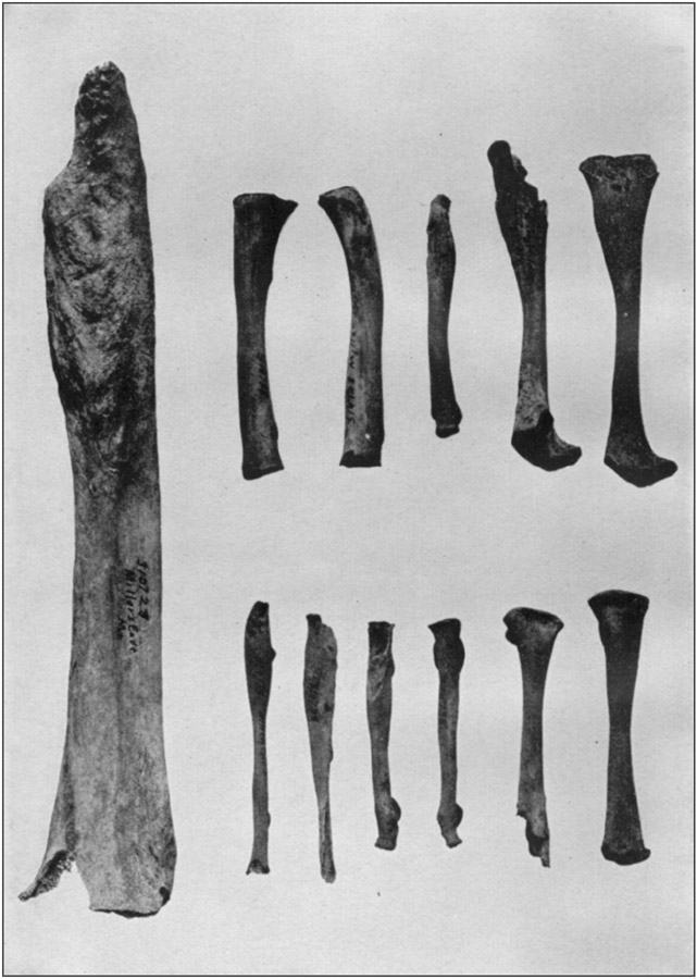
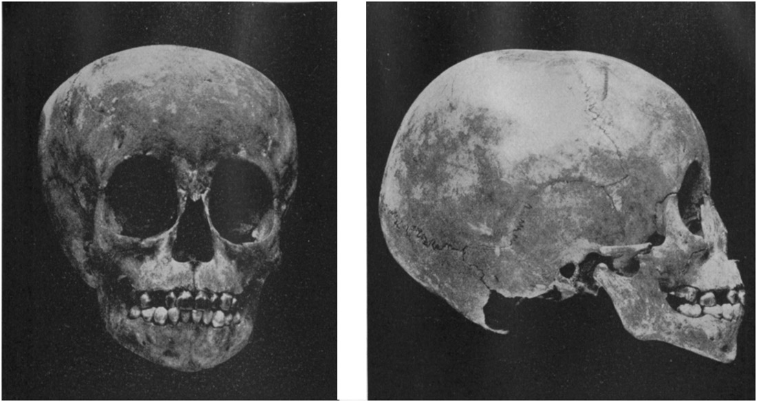
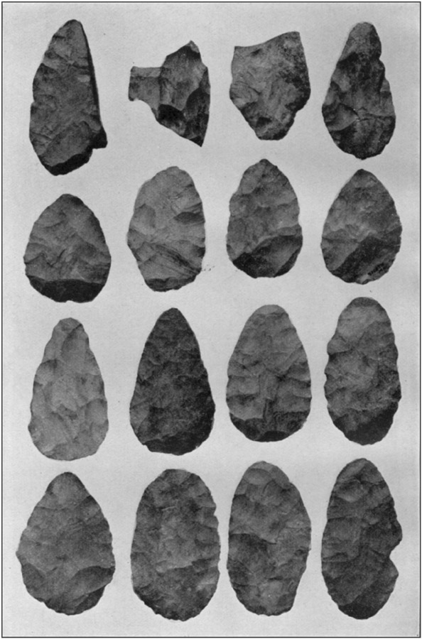
Near the west wall were four holes in an almost straight north-and-south line. The first (1), was 29 feet north of the doorway, 18 inches deep and 7 inches in diameter. In it was the clay pipe shown in figure 14. Number (2), 5 feet from (1), was 24 by 9 inches; No. (3) 2 feet from (2), was 26 by 7 inches; No. (4), 4½ feet from (3), was 30 by 5 inches. Fourteen inches northwest of No. (1) was another hole, 15 by 3 inches. The description on a previous page as to character, appearance, and contents applies to all these holes; the ashes extended above all of them in continuous layers.
A little to the west of No. (1) was a small pile of crumbling fragments of sandstone and limestone used in boiling food.
Near No. (4), a foot under the surface, on the slope, 15 feet from the water, was a small pile of charcoal on which lay a human scapula, some vertebræ, fragments of ribs, most of a humerus, and most of a femur of a person not fully matured; they were of good size but the cap fell away from the humerus when it was moved. Some of them were without marks of fire, others were charred, while a few pieces were burned to cinder. As the mass was surrounded by clean ashes, it could not be determined whether the charcoal had been burned where found, or had been carried here. Whichever it was, the bones had been thrown on the pile.
Thirteen feet just north from the corner of the west wall was a hole 19 by 7 inches which differed from the others in that the bottom instead of being rounded was irregular, and deeper at one side; the top, however, showed the usual hemispherical contour.
Two feet from corner of west wall, almost under a point projecting from it, 4 feet below surface, was a cranium from which the upper jaw, one orbit, and part of the right parietal were missing; with it were a lower jaw, a clavicle, a sternum, the bones of the left arm, and some phalanges, all in good condition, except the ulna, which was broken. No other bones were present. The skull lay on right side, face toward the wall; the arm bones were on it, and the other bones by it. With and around them were some deer bones. The entire lot had the appearance of being thrown together here at one time, and it would seem that the flesh of all of them had been eaten.
Fourteen feet north from the corner, halfway down to the water, in the wet earth at the bottom, were human bones evidently placed here entire, but so decayed and broken that nothing could be ascertained except that it seemed a closely folded body or skeleton had been deposited. The teeth were worn down to the gums.
The refuse behind the corner of the west wall was cleared away as far as the conditions would permit. The amount of water at the [74]rear of the cave varies with the rainfall; sometimes it almost disappears, again it may be fully 2 feet deep; but at all times the earth and ashes near it are saturated above its lowest level. Consequently, on account of the mud, excavations could not be carried fully to the end in either direction. As scarcely anything was found in the last few feet, this omission was not important.
The entire distance worked over, from the front margin to the line where no further advance could be made, at 14 feet from the water, was 91 feet. No spot that could be reached throughout this length was left undug.
The small openings in the west wall presented no features worthy of special mention; but those in the east wall yielded interesting results.
First of these was a small cave 39 feet from the main entrance. At the front its width was 11 feet; 6 feet within it narrowed to 4 feet. A hole on the north side ended at a crevice that led to a chamber higher up, from which, in turn, another crevice extended. All this space, even beyond the point to which a man could worm his way, was filled with fine earth and ashes containing much refuse. Worked objects were found at the greatest distance which could be reached.
A few feet within the entrance this minor cave divided into three parts. A crevice trending northward is too small to follow. The two others extend in a general easterly direction. The central branch, the left of the two, also closes within a few feet. Neither of these contained anything but natural earth. In the one to the right, 7 feet from the entrance, was a pocket on the south side, 18 inches wide, 30 inches high, and 4 feet deep; it was filled with ashes containing bone and shell, but no worked object except a flake scraper. At intervals, within the next few feet, were two mortars, a much used pestle, some bone awls, and flints, all of them in places where it was scarcely possible for a man to sit erect, as the tunnel-like cavity, circumscribed by solid rock, was nowhere as much as 4 feet in diameter. At its narrowest part it measured only 3 feet high and 18 inches wide.
At 20 feet the cave opens into a well-like enlargement, 5 by 6 feet, and 5 feet high. Bone and shell in small amounts were found here, and among them the skiver shown at d in plate 36.
From this well-like cavity three branches start; one continuing in a direct line east, one to the north, and one to the south. The east (middle) branch is only 24 inches high and 17 inches wide, with solid rock all around. It contained ashes, with a little refuse, as far as a man could reach.
The branch to the north is entered through an opening 3 feet high and 31 inches wide in a thin wall of the original rock, just within [75]which it widens to nearly 7 feet, holding the same height of 3 feet. Within this doorway, on the red earth bottom, were a small mortar and a grinding stone worn by much use; both were stained with red paint. A foot farther in was part of a skiver; and 2 feet beyond this was a large knife of white chert almost as clear and compact as chalcedony, shown at a in plate 27. Ashes continued in the north tunnel for 26 feet from the entrance, beyond which no further progress was possible. Before this point was reached, the refuse which had been continually decreasing in amount no longer appeared.
The tunnel leading from the well toward the south is 19 inches high, 3 feet 9 inches wide. At 3 feet it branches; one fork, 2 feet high and 17 inches wide, turns eastward and curves to join the east branch from the well. The other branch continues south, but soon closes; in it were found a small piece of an adult's skull and the hip bone of a young child.
The floors in all the branches of the small cave were covered from 3 to 12 inches deep with a reddish mixture of sand and clay, on which were ashes filling the space above almost to the roof. In a few places refuse was found in this silt, of the same general character as that in the ashes, but in very small amount. This is not significant; such remains were dragged down by animals, which range everywhere. The two deposits are quite separated and distinct.
The clay and sand on the rock bottom came from disintegrated rock on top of the ground outside, or at any rate from some level higher than that where they are found now; but how ashes, shells, broken bone, and especially how worked objects came to be in places too contracted for a man to creep, and where they could be neither carried nor pushed, is not to be explained except on the hypothesis of a chamber above, whence they may have worked or may have been thrown down; but at no place, either in the cave or in the outside surface, could there be found any evidence of such communication.
Fifty-five feet from the mouth of the cave, in the east wall, is a crevice into whose lower portion extended the red clay of the cavern floor. It branched into various tortuous divisions, all of which were filled with ashes containing a large proportion of refuse. It appeared at first that all this had settled in, or been thrown in, from the main cavern; but one branch, having a very irregular outline, was in such situation and trended upward at such an angle that it could not have been filled from below. As in similar cases previously noted, however, no other opening to it was to be found. The smallest workman cleared it out to as great a distance as he could crawl and use a trowel, but did not succeed in reaching the end of the deposits.
At the bottom of the crevice were ground-hog burrows extending between loose rocks, under ledges, and into the red clay. All these [76]were followed as far as they could be, and found to contain quantities of refuse. There was also a considerable amount of fine dark earth in the burrows, showing they have another outlet somewhere. Occasionally a mass thrown out by a shovel or a trowel contained more refuse than ashes. There was nearly everything which was found elsewhere in the cave, and almost every shovelful contained something worth preserving.
Near the rear of the cave erosion of the lower part of the eastern wall formed a rudely triangular recess or cavity 30 feet long by 7 feet deep at the widest part. The upper margin of this was below the surface of the ashes, so that its existence was not suspected until these had been removed from in front of it. The roof was 5 feet above the rock bottom, the entire space being filled with loose material. The upper 2 feet of this was clean ashes in which were great quantities of refuse, so much that it had all the appearance of a general dumping ground. Below this depth, patches of fine dark earth were mingled with the ashes and refuse. The latter continually decreased in quantity, until at a foot above the bottom they ceased altogether, the lower portion of the deposit consisting of nothing but earth. The pure ashes were slightly damp; and the moisture increased with the depth until at a foot above the bottom the earth was saturated and could no longer be removed with tools.
The refuse in the ashes consisted of animal bones, entire or in fragments; broken flints and pottery; mussel and snail shells; and numerous wrought objects. These continued, though in smaller amount, where the ashes were mingled with earth, though bones and shells were soft owing to the moisture, and could be removed only in fragments. Among them were the flint shown at a in plate 28, and the hematite ax, at a, plate 29. The latter was at the lowest level to which the ashes extended; perhaps its weight caused it to settle below the place at which it originally lay.
Near the middle of this chamber, 2 feet from the rear wall, lying at the bottom of the mixed ashes and earth, were 12 entire and 3 broken leaf-shaped blades; they were not closely piled, or arranged in any order, but seem to have been hastily or carelessly laid or thrown on a small space. Another was found a foot away. They are shown in plate 25.
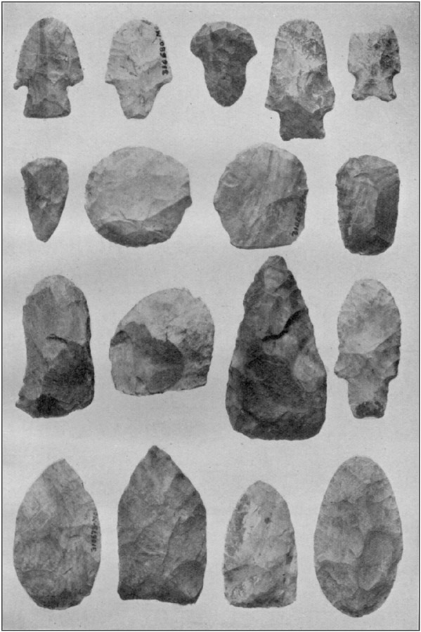
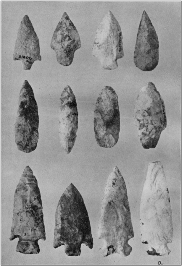
No comments:
Post a Comment