
CHAP. III.
Account of the Russian and Chinese settlements upon the confines of Siberia—description of the Russian frontier town Kiachta—of the Chinese frontier town Maimatschin—its buildings, pagodas, &c.
By the last mentioned treaty it was stipulated, that the commerce between Russia and China should be transacted at the frontiers. |Russian and Chinese Settlement upon the Brook Kiachta.| Accordingly two spots were marked out for that purpose upon the confines of Siberia, where they border upon the Mongol desert; one near the brook Kiachta, and the other at Zuruchaitu. The description of the former of these places forms the subject of this chapter.This settlement consists of a Russian and Chinese town, both situated in a romantic valley, surrounded by high, rocky, and for the most part well-wooded, mountains. This valley is intersected by the brook Kiachta, which rises in Siberia, and, after washing both the Russian and Chinese town, falls into the Bura, at a small distance from the frontiers.
Situation of the Russian Frontier Town Kiachta.
The Russian settlement is called Kiachta from the abovementioned brook: it lies in 124 degrees 18 mi[Pg 212]nutes longitude from the isle of Fero, and 35 degrees N. latitude, at the distance of 5514 versts from Moscow, and 1532 from Pekin.
The Fortress.
It consists of a fortress and a small suburb. The fortress, which is built upon a gentle rise, is a square enclosed with palisadoes, and strengthened with wooden bastions at the several angles. There are three gates, at which guards are constantly stationed: one of the gates faces the North, a second the South towards the Chinese frontiers, and a third the East close to the brook Kiachta. The principal public buildings in the fortress are a wooden church, the governor's house, the custom house, the magazine for provisions, and the guard-house. It contains also a range of shops and warehouses, barracks for the garrison, and several houses belonging to the crown; the latter are generally inhabited by the principal merchants. These buildings are mostly of wood.
Suburb.
The suburb, which is surrounded with a wooden wall covered at the top with chevaux de frize, contains no more than an hundred and twenty houses very irregularly built; it has the same number of gates as the fortress, which are also guarded. Without this suburb, upon the high road leading to Selenginsk, stand a few houses, and the magazine for rhubarb.[Pg 213]
This settlement is but indifferently provided with water both in quality and quantity; for although the brook Kiachta is dammed up as it flows by the fortress, yet it is so shallow in summer, that, unless after heavy rains, it is scarcely sufficient to supply the inhabitants. Its stream is troubled and unwholesome, and the springs which rise in the neighbourhood are either foul or brackish: from these circumstances, the principal inhabitants are obliged to send for water from a spring in the Chinese district. The soil of the adjacent country is mostly sand or rock, and extremely barren. If the frontiers of Russia were extended about nine versts more South to the rivulet of Bura; the inhabitants of Kiachta would then enjoy good water, a fruitful soil, and plenty of fish, all which advantages are at present confined to the Chinese.
The garrison of Kiachta consists of a company of regular soldiers, and a certain number of Cossacs; the former are occasionally changed, but the latter are fixed inhabitants of the place. It is the province of the commander to inspect the frontiers, and, in conjunction with the president of the Chinese merchants, to settle all affairs of an inferior nature; but in matters of importance recourse must be had to the chancery of Selenginsk, and to the governor of Irkutsk. The Russian[Pg 214] merchants, and the agents of the Russian trading company, are the principal inhabitants of Kiachta.
The limits Westwards from this settlement to the river Selenga, and Eastwards as far as Tchikoi, are bounded with chevaux de frize, placed there to prevent a contraband trade in cattle, for the exportation of which a considerable duty is paid to the crown. All the outposts along the frontiers Westwards as far as the government of Tobolsk, and Eastwards to the mountains of snow, are under the command of the governor of Kiachta.
The most elevated of the mountains that surround the valley of Kiachta, and which is called by the Mongols Burgultei, commands the Russian as well as the Chinese town; for this reason, the Chinese, at the conclusion of the last frontier treaty, demanded the cession of this mountain under the pretext, that some of their deified ancestors were buried upon its summit. The Russians gave way to their request, and suffered the boundary to be brought back to the North side of the mountain.
Maimatschin, the Chinese Frontier-Town.
The Chinese town is called, by the Chinese and Mongols, Maimatschin, which signifies fortress of commerce. The Russians term it the Chinese Village (Kitaiskaia[Pg 215] Sloboda) and also Naimatschin, which is a corruption of Maimatschin. It is situated about an hundred and forty yards South of the fortress of Kiachta, and nearly parallel to it. Midway between this place and the Russian fortress, two posts about ten feet high are planted in order to mark the frontiers of the two empires: one is inscribed with Russian, the other with Manshur characters[92].Mainatschin has no other fortification than a wooden wall, and a small ditch of about three feet broad; the latter was dug in the year 1756, during the war between the Chinese and the Calmucs. The town is of an oblong form: its length is seven hundred yards, and its breadth four hundred. On each of the four sides a large gate faces the principal streets; over each of these gates there is a wooden guard-house for the Chinese garrison, which consists of Mongols in tattered clothes, and armed with clubs. Without the gate, which looks to the Russian frontiers, and about the distance of eight yards from the entrance, the Chinese have raised a wooden screen, so constructed as to intercept all view of the streets from without.
[Pg 216]
This town contains two hundred houses and about twelve hundred inhabitants. It has two principal streets of about eight yards broad, crossing each other in the middle at right angles, with two by-streets running from North to South. They are not paved, but are laid with gravel, and kept remarkably clean.
Houses.
The houses are spacious, uniformly built of wood, of only one story, not more than fourteen feet high, plaistered and white-washed; they are constructed round a court yard of about seventy feet square, which is strewed with gravel, and has an appearance of neatness. Each house consists of a sitting room, some warehouses and a kitchen. In the houses of the wealthier sort the roof is made of plank; but in meaner habitations of lath covered over with turf. Towards the streets most of the houses have arcades of wood projecting forwards from the roof like a penthouse, and supported by strong pillars. The windows are large after the European manner, but on account of the dearness of glass and Russian talk are generally of paper, excepting a few panes of glass in the sitting room.The sitting room looks seldom towards the streets: it is a kind of shop, where the several patterns of merchandize are placed in recesses, fitted up with shelves,[Pg 217] and secured with paper doors for the purpose of keeping out the dust. The windows are generally ornamented with little paintings, and the walls are hung with Chinese paper. Half the floor is of hard beaten clay; the other half is covered with boards, and rises about two feet in height. Here the family sit in the day-time and sleep at night. By the side of this raised part, and nearly upon the same level, there is a square brick stove, with a streight perpendicular cylindrical excavation, which is heated with small pieces of wood. From the bottom of this stove a tube descends, and is carried zigzag under the boarded floor above-mentioned, and from thence to a chimney which opens into the street. By this contrivance, although the stove is always open and the flame visible, yet the room is never troubled in the least degree with smoke. There is scarcely any furniture in the room, excepting one large dining table in the lower part, and two small lackered ones upon the raised floor: one of these tables is always provided with a chaffing dish, which serves to light their pipes when the stove is not heated.
In this room there are several small niches covered with silken curtains, before which are placed lamps that are lighted upon festivals; these niches contain painted paper idols, a stone or metal vessel, wherein the ashes of incense are collected, several small orna[Pg 218]ments and artificial flowers: the Chinese readily allow strangers to draw aside the curtains, and look at the idols.
The Bucharian[93] merchants inhabit the South West quarter of Maimatschin. Their houses are not so large nor commodious as those of the Chinese, although the greatest part of them carry on a very considerable commerce.
The Governor of Maimatschin.
The Surgutschèi, or governor of Maimatschin, has the care of the police, as well as the direction of all affairs relating to commerce: he is generally a person of rank, oftentimes a Mandarin, who has misbehaved himself in another station, and is sent here as a kind of punishment. He is distinguished from the rest by the crystal button of his cap, and by a peacock's[94] fea[Pg 219]ther hanging behind. The Chinese give him the title of Amban, which signifies commander in chief; and no one appears before him without bending the knee, in which posture the person who brings a petition must remain until he receives the governor's answer. His salary is not large; but the presents which he receives from the merchants amount annually to a considerable sum.The most remarkable public buildings in Maimatschin, are the governor's house, the theatre, and two pagodas.
House of the Governor.
The governor's house is larger than the others, and better furnished; it is distinguished by a chamber where the court of justice is held, and by two high poles before the entrance ornamented with flags.
Theatre.
The theatre is situated close to the wall of the town near the great pagoda: it is a kind of small shed, neatly painted, open in front, and merely spacious enough to contain the stage; the audience stand in the street. Near it are two high poles, upon which large flags with Chinese inscriptions are hoisted on festivals. On such occasions the servants belonging to the merchants play short burlesque farces in honour of their idols.[Pg 220]
The small Pagoda.
The smallest of the two Pagodas is a wooden building, standing upon pillars, in the centre of the town at the place where the two principal streets cross. It is a Chinese tower of two stories, adorned on the outside with small columns, paintings, and little iron bells, &c. The first story is square, the second octangular. |The Idol Tien.| In the lower story is a picture representing the God Tien, which signifies, according to the explanation of the most intelligent Chinese, the most high God, who rules over the thirty-two heavens. The Manshurs, it is said, call this idol Abcho; and the Mongols, Tingheru heaven, or the God of heaven. He is represented sitting with his head uncovered, and encircled with a ray[95] of glory similar to that which surrounds the head of our Saviour in the Roman catholic paintings; his hair is long and flowing; he holds in his right hand a drawn sword, and his left is extended as in the act of giving a benediction. On one side of this figure two youths, on the other a maiden and a grey-headed old man, are delineated.[Pg 221]
The upper story contains the picture of another idol in a black and white checquered cap, with the same figures of three young persons and a little old man. There are no altars in this temple, and no other ornaments excepting these pictures and their frames. It is opened only on festivals, and strangers cannot see it without permission.
The great Pagoda and its Idols.
The great Pagoda[96], situated before the governor's house, and near the principal gate looking to the south, is larger and more magnificent than the former. Strangers are allowed to see it at all times, without the least difficulty, provided they are accompanied by one of the priests, who are always to be found in the area of the temple. This area is surrounded with chevaux de frize: the entrance is from the south through two gates with a small building between them. In the inside of this building are two recesses with rails before them, behind which the images of two horses as big as life are coarsly moulded out of clay; they are saddled and bridled, and attended by two human figures dressed like grooms: the horse to the right is of a chesnut colour, the other is dun with a black mane and tail, the former is in the[Pg 222] attitude of springing, the latter of walking. Near each horse a banner of yellow silk, painted with silver dragons, is displayed.In the middle of this area are two wooden turrets surrounded with galleries; a large bell of cart iron which is struck occasionally with a large wooden mallet, hangs in the Eastern turret; the other contains two kettle drums of an enormous size, similar to those made use of in the religious ceremonies of the Calmucs. On each side of this area are ranges of buildings inhabited by the priest of the temple.
This area communicates by means of an handsome gateway with the inner court, which is bordered on each side by small compartments open in front, with rails before them; in the inside of these compartments the legendary stories of the idols are exhibited in a series of historical paintings. At the farther extremity of this court stands a large building, constructed in the same style of architecture as the temple. The inside is sixty feet long and thirty broad: it is stored with antient weapons, and instruments of war of a prodigious size; such as spears, scythes, and long pikes, with broad blades, shields, coats of arms, and military ensigns representing hands[97], dragons heads, and other carved[Pg 223] figures. All these warlike instruments are richly gilded, and ranged in order upon scaffolds along the wall. Opposite the entrance a large yellow standard, embroidered with foliage and silver dragons, is erected; under it, upon a kind of altar, there is a series of little oblong tables, bearing Chinese inscriptions.
An open gallery, adorned on both sides with flower-pots, leads from the back door of the armoury to the colonade of the temple. In this colonade two slate tablets are placed, in wooden frames, about six feet high and two broad, with long inscriptions relating to the building of the temple. Before one of these plates a small idol of an hideous form stands upon the ground, enclosed in a wooden case.
The temple itself is an elegant Chinese building, richly decorated on the outside with columns lackered, and gilded carved-work, small bells, and other ornaments peculiar to the Chinese architecture. Within there is a rich profusion of gilding, which corresponds with the gaudiness of the exterior. The walls are covered thick with paintings, exhibiting the most celebrated exploits of the principal idol.
This temple contains five idols of a colossal stature, sitting cross-legged upon pedestals in three recesses, which fill the whole Northern side.
[Pg 224]
Ghessur Chan, the principal idol.
The principal idol is seated alone, in the middle recess, between two columns, entwined with gilded dragons. Large streamers of silk, hanging from the roof of the temple, veil in some measure the upper part of the image. His name is Ghedsur, or Ghessur Chan[98]; the Chinese call him Loo-ye, or the first and most antient; and the Manshurs, Guanlöe, or the superior god. He is of a gigantic size, surpassing more than fourfold the human stature, with a face glistening like burnished gold, black hair and beard. He wears a crown upon his head, and is richly dressed in the Chinese fashion: his garments are not moulded out of clay, as those of the other idols; but are made of the finest silk. He holds in his hands a kind of tablet, which he seems to read with deep attention. Two small female figures, resembling girls of about fourteen years of age, stand on[Pg 225] each side of the idol, upon the same pedestal; one of which grasps a roll of paper. At the right-hand of the idol lie seven golden arrows, and at his left a bow.Before the idol is a spacious enclosure, surrounded with rails, within which stands an altar with four colossal figures, intended probably to represent the principal mandarins of the deified Ghessur. Two of these figures are dressed like judges, and hold before them small tablets, similar to that in the hands of the principal idol. The two other figures are accoutred in complete armour: one wears a turban; and carries, upon the left shoulder, a large sword sheathed, with the hilt upwards. The other has an hideous copper-coloured face, a large belly, and grasps in his right hand a lance with a broad blade.
Although all the remaining idols in the temple are of an enormous size, yet they are greatly surpassed in magnitude by Ghessur Chan.
Maooang.
The first idol in the recess to the right is called Maooang, or the Otschibanni of the Mongols. He has three ghastly copper-coloured faces, and six arms; two of his arms brandish two sabres cross ways over the head; a third bears a looking glass, and a fourth a kind of square, which resembles a piece of ivory. The two remaining[Pg 226] arms are employed in drawing a bow, with an arrow laid upon it, ready to be discharged. This idol has a mirror upon his breast, and an eye in his navel: near it are placed two small figures; one holds an arrow, and the other a little animal.
Tsaudsing.
The next idol in the same recess is called by the Chinese Tsaudsing, or the gold and silver god; and by the Mongols Tsagan-Dsambala. He wears a black cap, and is dressed, after the Chinese fashion, in sumptuous robes of state; he bears in his hand a small jewel casket. Near him also stand two little figures, one of which holds a truncated branch.
Chusho.
In the recess to the left is the god Chusho, called by the Manshurs Chua-schan, and by the Mongols Galdi, or the Fire God. He is represented with a frightful fiery reddish face; clad in complete armour he wields a sword half drawn out of the scabbard, and seems on the point of starting up from his seat. He is attended by two little harlbadeers, one of whom is crying; and the other bears a fowl upon his hand, which resembles a sea-pheasant.
Niu-o.
The other idol in the same recess is the god of oxen, Niu-o. He appears to be sitting in a composed posture; he is habited like a Mandarin, and is distinguished by a[Pg 227] crown upon his head. He has, in common with the other idols, a mirror upon his breast. The Chinese imagine him to be the same with the Yamandaga of the Mongols; and it is said his Manshurish name is Chain Killova; his Mongol name, which relates to the history of Ghessur, is Bars-Batir, the Hero of Tygers.Before these several idols there are tables, or altars, on which cakes, pastry, dried fruit, and flesh, are placed, on festivals and prayer days: on particular occasions even whole carcases of sheep are offered up. Tapers and lamps are kept burning day and night before the idols. Among the utensils of the temple, the most remarkable is a vessel shaped like a quiver, and filled with flat pieces of cleft reed, on which short Chinese devices are inscribed. These devices are taken out by the Chinese on new-years day, and are considered as oracles, which foretel the good or ill luck of the person, by whom they are drawn, during the following year. There lies also upon a table an hollow wooden black lackered helmet, which all persons of devotion strike with a wooden hammer, whenever they enter the temple. This helmet is regarded with such peculiar awe, that no strangers are permitted to handle it, although they are allowed to touch even the idols themselves.
The first day of the new and full moon is appointed for the celebration of worship. Upon each of those days[Pg 228] no Chinese ever fails to make his appearance once in the temple; he enters without taking off his cap[99], joins his hands before his face, bows five times to each idol, touches with his forehead the pedestal on which the idol sits, and then retires. Their principal festivals are held in the first month of their year, which answers to February. It is called by them, as well as by the Mongols, the white month; and is considered as a lucky time for the transaction of business; at that time they hoist flags before the temples; and place meat upon the tables of the idols, which the priests take away in the evening, and eat in the small apartments of the interior court. On these solemnities plays are performed in the theatre, in honour of the idols: the pieces are generally satyrical, and mostly written against unjust magistrates and judges.
Superstion of the Chinese.
But although the Chinese have such few ceremonies in their system of religious worship, yet they are remarkably infected with superstition. Mr. Pallas gives the following description of their behaviour at Maimatschin during an eclipse of the moon. At the close of the evening in which the eclipse appeared, all the inhabitants were indefatigable in raising an incessant uproar, [Pg 229] some by hideous shrieks, others by knocking wood, and beating cauldrons; the din was heightened by striking the bell and beating the kettle drums of the great Pagoda. The Chinese suppose, that during an eclipse the wicked spirit of the air, called by the Mongols Arachulla, is attacking the moon; and that he is frightened away by these hideous shrieks and noises. Another instance of superstition fell under the observation, of Mr. Pallas, while he was at Maimatschin. A fire broke out in that town with such violence that several houses were in flames. None of the inhabitants, however, attempted to extinguish it; they stood indeed in idle consternation round the fire; and some of them sprinkled occasionally water among the flames, in order to sooth the fire god, who, as they imagined, had chosen their houses for a sacrifice. Indeed if the Russians had not exerted themselves in quenching the fire, the whole place would probably have been reduced to ashes[100].[Pg 231]
CHAP. IV.
Commerce between the Chinese and Russians—list of the principal exports and imports—duties—average amount of the Russian trade.
Merchants of Maimatschin.
The merchants of Maimatschin come from the Northern provinces of China, chiefly from Pekin, Nankin, Sandchue, and other principal towns. They are not settled at this place with their wives and families: for it is a remarkable circumstance, that there is not one woman in Maimatschin. This restriction arises from the policy of the Chinese government, which, totally prohibits the women from having the slightest intercourse with foreigners. No Chinese merchant engages in the trade to Siberia who has not a partner. These persons mutually relieve each other. One remains for a stated time, usually a year, at Kiachta; and when, his partner arrives with a fresh cargo of Chinese merchandize, he then returns home with the Russian commodities[101].Most of the Chinese merchants understand the Mongol tongue, in which language commercial affairs are[Pg 232] generally transacted. Some few indeed speak broken Russian, but their pronunciation is so soft and delicate, that it is difficult to comprehend them. They are not able to pronounce the R, but instead of it make use of an L; and when two consonants come together, which frequently occurs in the Russian tongue, they divide them by the interposition of a vowel[102]. This failure in articulating the Russian language seems peculiar to the Chinese, and is not observable in the Calmucs, Mongols, and other neighbouring nations[103].
The commerce between the Russians and Chinese is entirely a trade of barter, that is, an exchange of one merchandize for another. The Russians are prohibited to export their own coin, nor indeed could the Chinese[Pg 233] receive it, even should that prohibition be taken off; for no specie is current amongst them except bullion[104]. And the Russians find it more advantageous to take merchandize in exchange, than to receive bullion at the Chinese standard. The common method of transacting business is as follows. The Chinese merchant comes first to Kiachta, and examines the merchandize he has occasion for in the warehouse of the Russian trader;[Pg 234] he then goes to the house of the latter, and adjusts the price over a dish of tea. Both parties next return to the magazine, and the goods in question are there carefully sealed in the presence of the Chinese merchant. When this ceremony is over, they both repair to Maimatschin; the Russian chooses the commodities he wants, not forgetting to guard against fraud by a strict inspection. He then takes the precaution to leave behind a person of confidence, who remains in the warehouse until the Russian goods are delivered, when he returns to Kiachta with the Chinese merchandize[105].
Russian Exports.
The principal commodities which Russia exports to China are as follow:
FURS and PELTRY.
It would be uninteresting to enumerate all the furs and skins[106] brought for sale to Kiachta, which form the most important article of exportation on the side of the Russians. The most valuable of these furs are the skins of sea-otters, beavers, foxes, wolves, bears, Bucharian lambs, Astracan sheep, martens, sables, ermines, grey-squirrels.[Pg 235]
The greatest part of these furs and skins are drawn from Siberia and the New Discovered Islands: this supply however is not alone fully adequate to the demand of the market at Kiachta. Foreign furs are therefore imported to St. Petersburg, and from thence sent to the frontiers. England alone furnishes a large quantity of beaver and other skins, which she draws from Hudson's Bay and Canada.[107]
CLOTH.
Cloth forms the second article of exportation which Russia exports to China.[Pg 236]
| The coarse sort is manufactured in Russia; the finer sort is foreign, chiefly English, Prussian, and French. | |
| An arshire of foreign cloth fetches, according to its fineness, from | 2 to 4 roubles. |
| Camlets. | |
| Calimancoes. | |
| Druggets. | |
| White flannels, both Russian and foreign. | |
| The remaining articles are, | |
| Rich stuffs. | |
| Velvets. | |
| Coarse linen, chiefly manufactured in Russia. | |
| Russia leather. | |
| Tanned hides. | |
| Glass ware and looking glasses. | |
| Hardware, namely, knives, scissars, locks, &c. | |
| Tin. | |
| Russian talk. | |
| Cattle, chiefly camels, horses, and horned cattle. | |
| The Chinese also pay very dear for hounds, greyhounds, barbets, and dogs for hunting wild boars. | |
| Provisions[108]. | |
| Meal.—The Chinese no longer import such large quantities of meal as formerly, since they have employed the Mongols to cultivate the lands lying near the river Orchon[109], &c. &c. | |
Imports.
List of the most valuable commodities procured from China.
RAW AND MANUFACTURED SILK.
The exportation of raw silk is prohibited in China under pain of death: large quantities however are smuggled every year into Kiachta, but not sufficient to answer the demands of the Russian merchants.| A pood | of the best sort is estimated at | 150 roubles; |
| of the worst sort at | 75 |
RAW AND MANUFACTURED COTTON.
Raw cotton is imported in very large quantities; a great part of this commodity is employed in packing up the china ware, and by these means is conveyed into[Pg 238] the inland part of Russia without any additional expence of carriage.A pood sells for—from 4 roubles, 80 cop. to 12.
Of the manufactured cotton, that which the Russians call Kitaika, and the English Nankeen, has the most rapid sale. It is the most durable, and, in proportion to its goodness, the cheapest of all the Chinese stuffs; it is stained red, brown, green, and black.
TEAS.
The teas which are brought into Russia are much superior in flavour and quality to those which are sent to Europe from Canton. The original goodness of the teas is probably the same in both cases; but it is conjectured, that the transport by sea considerably impairs the aromatic flavour of the plant. This commodity, now become so favourite an object of European luxury, is esteemed by the Russian merchants the most profitable article of importation.| At Kiachta a pound of the best tea[110] is estimated at | 2 roubles. |
| Common ditto at | 1 |
| Inferior at | 40 copecs. |
PORCELAIN OF ALL SORTS.
For some years past the Chinese have brought to Kiachta parcels of porcelain, painted with European figures, with copies of several favourite prints and images of the Grecian and Roman deities.| Furniture, particularly Japan cabinets and cases, lackered and varnished tables and chairs, boxes inlaid with mother-of-pearl, &c. &c. |
| Fans, toys, and other small wares. |
| Artificial flowers. |
| Tiger and Panther skins. |
| Rubies[111], but neither in large quantities nor of great value. |
| White lead, vermilion, and other colours. |
| Canes. |
| Tobacco. |
| Rice. |
| Sugar Candy. |
| Preserved ginger, and other sweetmeats. |
| Rhubarb[112]. |
| Musk. |
It is very difficult to procure the genuine Thibet musk, because the Chinese purchase a bad sort, which comes from Siberia, with which they adulterate that which is brought from Thibet[113].
Advantages of this Trade to Russia.
Russia draws great advantages from the Chinese trade. By this traffic, its natural productions, and particularly its furs and skins, are disposed of in a very profitable manner. Many of these furs procured from the most Easterly parts of Siberia, are of such little value that they would not answer the expence of carriage into Russia; while the richer furs, which are sold to the Chinese at a very high price, would, on account of their dearness, seldom meet with purchasers in the Russian dominions. In exchange for these commodities the Russians receive from China several valuable articles of commerce, which they would otherwise be obliged to buy at a much dearer rate from the European powers, to the great disadvantage of the balance of their trade.I have before observed, that formerly the exportation and importation of the most valuable goods were prohibited to individuals; at present only the following articles are prohibited. Among the exports, fire-arms and artillery; gunpowder and ball; gold and silver, coined[Pg 241] and uncoined, stallions and mares; skins of deer, reindeer, elks, and horses; beaver's hair, potash, rosin, thread, and[114]tinsel-lace: among the imports, salt, brandy, poisons, copper-money, and rhubarb.
| The duties paid by the Russian-merchants are very considerable; great part of the merchandise is taxed at | 25 per cent. |
| Furs, cattle, and provisions, pay a duty of | 23. |
| Russian manufactures | 18. |
Some articles, both of export and import, pay no duty. The exported are, writing, royal, and post paper, Russia cloth of all sorts and colours, excepting peasants cloth. The imported are, satins, raw and stained cottons, porcelain, earthen-ware, glass corals, beads, fans, all musical instruments, furniture, lackered and enamelled ornaments, needles, white-lead, rice, preserved ginger, and other sweet-meats[115].
[Pg 242]
The importance of this trade will appear from the following table.
Table of exportation and importation.
Table of exportation and importation at Kiachta, in the year 1777.
| Rbles. | Cop. | |
| Custom-house duties, | 481,460. | 59-1/2. |
| Importation of Chinese goods, to the value of | 1,466,497. | 3-3/4. |
| Of gold and silver | 11,215. | |
| Total of Importation | 1,484,712. | 3-3/4. |
| Exportation of Russian commodities | 1,313,621. | 35. |
| From this table it appears, that the total sum of export and import amounts to | 2,868,333. |
[Pg 244]
CHAP. V.
Description of Zuruchaitu—and its trade—Transport of the merchandise through Siberia.
The general account of the Russian commerce to China has been given in the preceding chapter, because almost the whole traffic is confined to Kiachta. The description of Zuruchaitu, which was also fixed by the treaty of Kiachta for the purpose of carrying on the same trade, will be comprised of course in a narrow compass.
Description of Zuruchaitu.
Zuruchaitu is situated in 137° longitude, and 49°. 20´ N. latitude, upon the Western branch of the river Argoon, at a small distance from its source. It is provided with a small garrison, and a few wretched barracks surrounded with chevaux de frise. No merchants are settled at this place; they come every summer from Nershinsk, and other Russian towns in order to meet two parties of Mongol troops: these troops are sent from the Chinese towns Naun and Merghen, and arrive at the frontiers about July. They encamp near Zuruchaitu upon the other side of the river Argoon, and barter with the[Pg 245] Siberian merchants a few Chinese commodities, which they bring with them.
Commerce.
Formerly the commerce carried on at Zuruchaitu was more considerable; but at present it is so trifling, that it hardly deserves to be mentioned. These Mongols furnish the district of Nershinsk with bad tea and tobacco, bad silks, and some tolerable cottons. They receive in return ordinary furs, cloth, cattle, and Russian leather. This trade lasts about a month or six weeks, and the annual duties of the customs amount upon an average to no more than 500 roubles. About the middle of August the Mongols retire; part proceed immediately to China, and the others descend the stream of the Amoor as far as its mouth, in order to observe if there has been no usurpation upon the limits. At the same time the Russian merchants return to Nershinsk, and, were it not for the small garrison, Zuruchaitu would remain uninhabited[117].
Transport of the Russian and Chinese Commodities through Siberia.
The Russian commodities are transported by land from Petersburg and Moscow to Tobolsk. From thence the merchants may embark upon the Irtish down to its junction with the Oby; then they either tow up their boats, or sail up the last mentioned river as far as[Pg 246] Marym, where they enter the Ket, which they ascend to Makoffskoi Ostrog. At that place the merchandize is carried about ninety versts by land to the Yenisei. The merchants then ascend that river, the Tunguska, and Angara, to Irkutsk, cross the lake Baikal, and go up the river Selenga almost to Kiachta.It is a work of such difficulty to ascend the streams of so many rapid rivers, that this navigation Eastwards can hardly be finished in one summer[118]; for which reason the merchants commonly prefer the way by land. Their general rendezvous is the fair of Irbit near Tobolsk; from thence they go in sledges during winter to Kiachta where they arrive about February, the season in which the chief commerce is carried on with the Chinese. They buy in their route all the furs they find in the small towns, where they are brought from the adjacent countries. When the merchants return in spring with the Chinese goods, which are of greater bulk and weight than the Russian commodities, they proceed by water; they then descend the streams of most of the rivers, namely, the Selenga, Angara, Tunguska, Ket, and Oby to its junction with the Irtish; they ascend that river to Tobolsk, and continue by land to Moscow and Petersburg.
[Pg 247]
Transport of the Furs from Kamtchatka to Kiachta.
Before the passage from Ochotsk to Bolcheresk was discovered in 1716, the only communication between Kamtchatka and Siberia was by land; the road lay by Anadirsk to Yakutsk. The furs[119] of Kamtchatka and of the Eastern isles are now conveyed from that peninsula by water to Ochotsk; from thence to Yakutsk by land on horse-back, or by rein-deer: the roads are so very bad, lying either through a rugged mountainous country, or through marshy forests, that the journey lasts at least six weeks. Yakutsk is situated upon the Lena, and is the principal town, where the choicest furs are brought in their way to Kiachta, as well from Kamtchatka as from the Northern parts of Siberia, which lay upon the rivers Lena, Yana, and Endigirka. At Yakutsk the goods are embarked upon the Lena, towed up the stream of that river as far as Vercholensk, or still farther to Katsheg; from thence they are transported over a short tract of land to the rivulet Buguldeika, down that stream to the lake Baikal, across that lake to the mouth of the Selenga, and up that river to the neighbourhood of Kiachta.[Pg 248]
In order to give the reader some notion of that vast tract of country, over which the merchandize is frequently transported by land carriage, a list of the distances is here subjoined.
| From | Petersburg to Moscow | 734 | versts. |
| Moscow to Tobolsk | right | ||
| Tobolsk to Irkutsk | right | ||
| Irkutsk to Kiachta | 471 | ||
| 6508 | |||
| From | Irbit to Tobolsk | 420 | |
| From | Irkutsk to Nershinsk | 1129 | |
| Nershinsk to Zuruchaitu | 370 | ||
| From | Ochotsk to Yakutsk | 927 | |
| Yakutsk to Irkutsk | 2433 | ||
| From | Selenginsk to Zuruchaitu | 850 | |
| Zuruchaitu to Pekin | 1588 | ||
| Kiachta to Pekin | 1532 | ||
[Pg 249]
PART III.
APPENDIX I. & II.
CONTAINING
SUPPLEMENTARY ACCOUNTS
OF THE
RUSSIAN DISCOVERIES, &c. &c.
[Pg 251]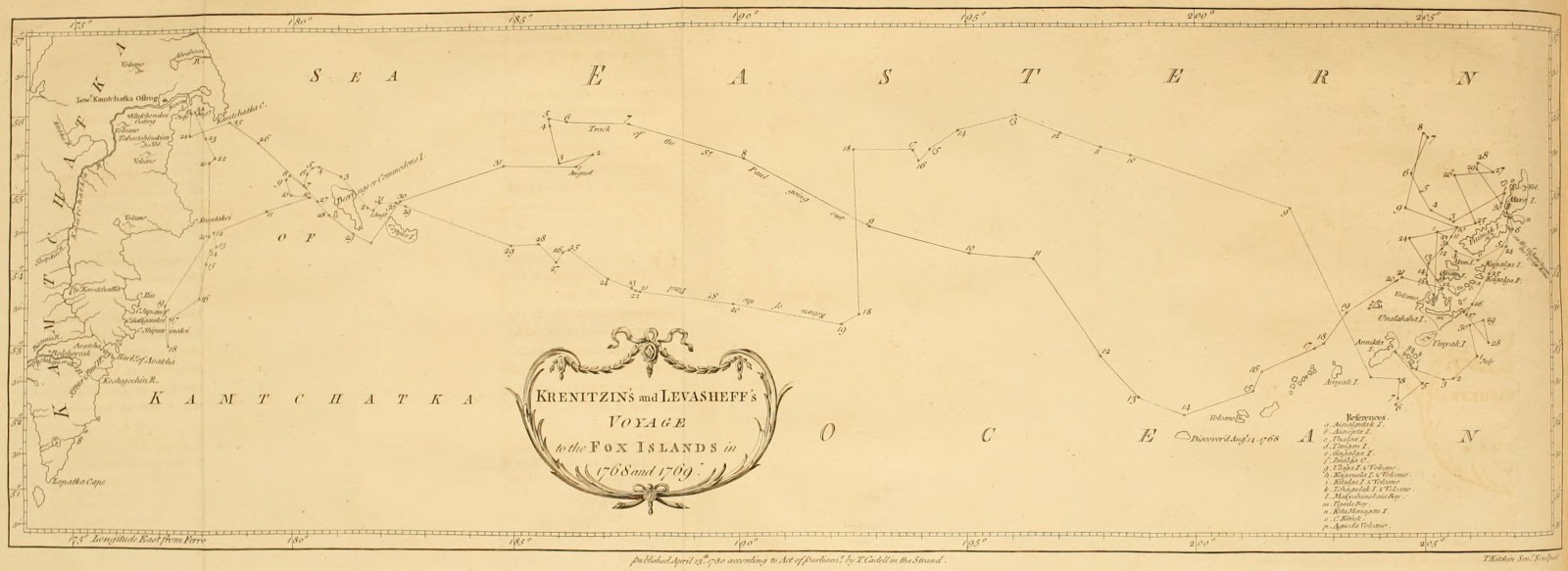 Krenitzin's and Levasheff's Voyage to the Fox Islands in 1768 and 1769.
APPENDIX I.
Extract from the journal of a voyage made by Captain Krenitzin and Lieutenant Levasheff to the Fox Islands, in 1768, 1769, by order of the Empress of Russia—they sail from Kamtchatka—arrive at Beering's and Copper Islands—reach the Fox Islands—Krenitzin winters at Alaxa—Levasheff upon Unalashka—productions of Unalashka—description of the inhabitants of the Fox Islands—their manners and customs, &c.
Krenitzin and Levasheff sail from the Mouth of the Kamtchatka River, 1768.
On the 23d of July Captain Krenitzin sailed in the Galliot St. Catherine from the mouth of the Kamtchatka river towards America: he was accompanied by Lieutenant Levasheff, in the Hooker St. Paul. Their instructions were regulated by information derived from Beering's expedition in 1741. Shaping their course accordingly, they found themselves more to the North than they expected; and were told by the Russian traders and hunters, that a similar[121] mistake was com[Pg 252]mitted in the chart of that expedition. These traders, who for some years past were accustomed to ramble to the distant islands in quest of furs, said that they were situated much more to the South, and farther East than was imagined. |They reach Beering's Island.| On the 27th they saw Commodore's or Beering's Island, which is low and rocky, especially to the S. W. On this side they observed a small harbour, distinguished by two hillocks like boats, and not far from it they found a fresh water lake.
and Copper Island.
To the S. E. lies another island, called by the Russians Mednoi Ostroff, or Copper Island, from a great quantity of copper found upon its N. E. coast, the only side which is known to the Russians. It is washed up by the sea, and covers the shore in such abundance, that many ships may load with it. Perhaps an India trader might make a profitable voyage from thence to China, where this metal is in high demand. This copper is mostly in a metallic or malleable state, and many pieces seem as if they had formerly been in fusion. The island is not high, but has many hillocks, each of which has the appearance of having formerly been the funnel of a volcano. We may here, once for all, observe, that all the islands represented in this chart[122] abound with such funnels, called in Russian Sopka, in so much that no island, however small, was found without one; and[Pg 253] many of them consisted of nothing else. In short, the chain of islands here laid down may, without any violent stretch of imagination, be considered as thrown up by some late volcanos. The apparent novelty of every thing seems to justify this conjecture: nor can any objection be derived from the vegetable productions with which these islands abound; for the summer after the lower district of Zutphen in Holland was gained from the sea, it was covered over with wild mustard. All these lands are subject to violent and frequent earth-quakes, and abound in sulphur. The writer of the journal was not able to inform us whether any lava was found upon them; but he speaks of a party-coloured stone as heavy as iron. From this account it is by no means improbable, that the copper abovementioned has been melted in some eruption.
Arrive at the Fox Islands.
After leaving Copper Island, no land was seen from either of the ships (which had parted company in a fog) till on the S. E. quarter of their tract, was discovered the chain of islands or head-lands laid down in the chart. These in general appeared low, the shore bad, without creeks, and the water between them very shallow. During their course outwards, as well as during their return, they had frequent fogs. It appears from the journal, as well as from the relation of the hunters,[Pg 254] that it is very uncommon to have clear weather for five days together, even during summer.
Krenitzin winters at Alaxa.
The St. Catherine wintered in the straits of Alaxa, where they hauled her into shoal water. The instructions given to the captain set forth, that a private ship had in 1762 found there a commodious haven; but he looked for it in vain. The entrance of this strait from the N. E. was extremely difficult on account of flats, and strong currents both flood and ebb: the entrance however from the S. E. was afterwards found to be much easier with not less than 5-1/2 fathoms water. Upon surveying this strait, and the coast of Alaxa, many funnels were observed in the low grounds close to the shore, and the soil produced few plants. May not this allow one to suppose that the coast had suffered considerable changes since the year 1762? Few of the islands produce wood, and that only in the vallies by the rivulets. Unalga and Alaxa contain the most; they abound with fresh water streams, and even rivers; from which we may infer that they are extensive. The soil is in general boggy, and covered with moss; but Alaxa has more soil and produces much grass.
Levasheff winters upon Unalashka.
The St. Paul wintered in Unalashka. This wintering place was observed to lie in 53° 29´ North latitude, and its longitude from the mouth of Kamtchatka river,[Pg 255] computed by the ship's journal, was 27° 05´ East[123]. Unalashka is about fifty miles long from N. E. to S. W. and has on the N. E. side three bays. One of them called Udagha stretches thirty miles E. N. E. and W. S. W. nearly through the middle of the island. Another called Igunck, lying N. N. E. and S. S. W. is a pretty good harbour, with three and a half fathom water at high tide, and sandy ground. It is well sheltered from the North swell at its entrance by rocks, some of which are under water. The tide flows here five feet at full and change, and the shore is in general bold and rocky, except in the bay, at the mouth of a small river. There are two burning mountains on this island, one called Ayaghish, and the other (by the Russians) the Roaring Mountain. Near the former is a very copious hot spring. The land is in general rocky, with loamy and clayey grounds; but the grass is extremely coarse, and unfit for pasture. Hardly any wood is to be found on it. |Productions of Unalashka.| Its plants are dwarf cherry ([124]Xylosteum of Tournefort), wortle berry, (Vaccinium Uliginosum of Linnæus), rasberry, farana and shikshu of Kamtchatka and kutage, larch, white poplar, pine and[Pg 256] birch[125]. The land animals are foxes of different colours, mice, and weasels; there are also beavers[126], sea cats, and sea lions as at Kamtchatka. Among their fish we may reckon cod, perch, pilchards, smelts, roach, needle fish, terpugh, and tchavitcha. The birds are eagles, partridges, ducks, teals, urili, ari, and gadi. The animals for whose Russian names I can find no translations, are (excepting the Ari) described in Krashininikoff's History of Kamtchatka, or in Steller's relation contained in the second volume of the Memoirs of the Academy of Petersburgh.
Account of the Inhabitants of the Fox Islands.
The inhabitants of Alaxa, Umnak, Unalaksha, and the neighbouring islands, are of a middle stature, tawny brown colour, and black hair. In summer they wear coats (parki[127]) made of bird skins, over which, in bad weather, and in their boats, they throw cloaks, called kamli, made of thin whale guts. On their heads they wear wooden caps, ornamented with duck's feathers,[Pg 257] and the ears of the sea-animal, called Scivutcha or sea-lion; they also adorn these caps with beads of different colours, and with little figures of bone or stone. In the partition of the nostrils they place a pin, about four inches long, made of the bone, or of the stalk of a certain black plant; from the ends of this pin or bodkin they hang, in fine weather and on festivals, rows of beads, one below the other. They thrust beads, and bits of pebble cut like teeth, into holes made in the under-lips. They also wear strings of beads in their ears, with bits of amber, which the inhabitants of the other islands procure from Alaxa, in exchange for arrows and kamli.They cut their hair before just above the eyes, and some shave the top of their heads like monks. Behind the hair is loose. The dress of the women hardly differs from that of the men, excepting that it is made of fish-skins. They sew with bone needles, and thread made of fish guts, fastening their work to the ground before them with bodkins. They go with the head uncovered, and the hair cut like that of the men before, but tied up behind in a high knot. They paint their cheeks with strokes of blue and red, and wear nose-pins, beads, and ear-rings like the men; they hang beads round their neck, and checkered strings round their arms and legs.
[Pg 258]
Manners and Customs.
In their persons we should reckon them extremely nasty. They eat the vermin with which their bodies are covered, and swallow the mucus from the nose. Having washed themselves, according to custom, first with urine, and then with water, they suck their hands dry. When they are sick, they lie three or four days without food; and if bleeding is necessary, they open a vein with lancets made of flint, and suck the blood.Their principal nourishment is fish and whale fat, which they commonly eat raw. They also feed upon sea-wrack and roots, particularly the saran, a species of lily; they eat a herb, called kutage, on account of its bitterness, only with fish or fat. They sometimes kindle fire by catching a spark among dry leaves and powder of sulphur: but the most common method is by rubbing two pieces of wood together, in the manner practised at Kamtchatka[128], and which Vaksel, Beering's lieutenant, found to be in use in that part of North America which he saw in 1741. They are very fond of Russian oil and butter, but not of bread. They could not be pre[Pg 259]vailed upon to taste any sugar until the commander shewed the example; finding it sweet, they put it up to carry it home to their wives.
The houses of these islanders are huts built precisely in the manner of those in Kamtchatka, with the entry through a hole in the middle of the roof. In one of these huts live several families, to the amount of thirty or forty persons. They keep themselves warm by means of whale fat burnt in shells, which they place between their legs. The women set apart from the men.
Six or seven of these huts or yourts make a village, of which there are sixteen in Unalashka. The islands seem in general to be well inhabited, as may be conjectured from the great number of boats which are seen continually plying along the shore. There are upwards of a thousand inhabitants on Unalashka, and they say that it was formerly much more populous. They have suffered greatly by their disputes with the Russians, and by a famine in the year 1762; but most of all from a change in their way of life. No longer contented with their original simplicity, they long for Russian luxuries: in order therefore to obtain a few delicacies, which are presently consumed, they dedicate the greatest part of their time to hunting, for the purpose of pro[Pg 260]curing furs for the Russians: by these means, they neglect to lay up a provision of fish and roots; and suffer their children frequently to die of hunger.
Their principal food is fish, which they catch with bone hooks. Their boats, in which they row to a great distance from land, are made, like those of the Innuet or Esquimaux, of thin slips of wood and skins: these skins cover the top as well as the sides of the boat, and are drawn tight round the waist of the rower. The oar is a paddle, broad at both ends. Some of their boats hold two persons; one of whom rows, and the other fishes: but these kind of boats seem appropriated to their chiefs. They have also large boats capable of holding forty men. They kill birds and beasts with darts made of bone, or of wood tipped with sharpened stone: they use these kind of darts in war, which break with the blow given by them, and leave the point in the wound.
The manners and character of these people are what we should expect from their necessitous situation, extremely rude and savage. The inhabitants however of Unalashka are somewhat less barbarous in their manners and behaviour to each other, and also more civil to strangers than the natives of the other islands; but[Pg 261] even they are engaged in frequent and bloody quarrels, and commit murder without the least compunction. Their disposition engages them in continual wars, in which they always endeavour to gain their point by stratagem. The inhabitants of Unimak are formidable to all the rest; they frequently invade the other islands, and carry off women, the chief object of their wars. Alaxa is most subject to these incursions, probably because it is more populous and extensive. They all join in hating the Russians, whom they consider as general invaders, and therefore kill them wherever they can. The people of Unalashka however are more friendly; for Lieutenant Levasheff, being informed that there was a Russian vessel in the straits of Alaxa, prevailed on some Unalashkans to carry a letter, which they undertook, notwithstanding the danger they were exposed to from the inhabitants of the intervening islands.
The journalist says, that these people have no kind of religion, nor any notion of a God. We observe however among them sufficient marks of such a religion as might be expected from people in their situation. For the journalist informs us, that they have fortune-tellers employed by them at their festivals. These persons pretend to foretel events by the information of the Kugans or Dæmons. In their divinations they put on[Pg 262] wooden masks, made in the form in which they say the Kugan appeared to them; they then dance with violent motions, beating at the same time drums covered with fish skins. The inhabitants also wear little figures on their caps, and place others round their huts, to keep off the devils. These are sufficient marks of a savage religion.
It is common for them to have two, three, or four wives, and some have also an object of unnatural affection, who is dressed like the women. The wives do not all live together, but, like the Kamtchadals, in different yourts. It is not unusual for the men to exchange their wives, and even sell them, in time of dearth, for a bladder of fat; the husband afterwards endeavours to get back his wife, if she is a favourite, and if unsuccessful he sometimes kills himself. When strangers arrive at a village, it is always customary for the women to go out to meet them, while the men remain at home: this is considered as a pledge of friendship and security. When a man dies in the hut belonging to his wife, she retires into a dark hole, where she remains forty days. The husband pays the same compliment to his favourite wife upon her death. When both parents die, the children are left to shift for themselves. The Russians found many in this situation, and some were brought for sale.
[Pg 263]
In each village there is a sort of chief, called Tookoo, who is not distinguished by any particular rank or authority. He decides differences by arbitration, and the neighbours enforce the sentence. When he goes out to sea he is exempted from working, and has a servant, called Kalè, for the purpose of rowing the canoe; this is the only mark of his dignity: at all other times he labours like the rest. The office is not hereditary; but is generally conferred on him who is most remarkable for his personal qualities; or who possesses a great influence by the number of his friends. Hence it frequently happens, that the person who has the largest family is chosen.
During their festivals, which are held after the fishing season ends in April, the men and women sing songs; the women dance, sometimes singly, and sometimes in pairs, waving in their hands blown bladders; they begin with gentle movements, which become at last extremely violent.
The inhabitants of Unalashka are called Kogholaghi. Those of Akutan, and farther East to Unimak, are called Kighigusi; and those of Unimak and Alaxa are called Kataghayekiki. They cannot tell whence they have these names, and now begin to call themselves by the general name of Aleyut, given them by the Russians,[Pg 264] and borrowed from some of the[129]Kuril islands. Upon being asked concerning their origin, they said that they had always inhabited these islands, and knew nothing of any other country beyond them. All that could be gathered from them was, that the greatest numbers came from Alaxa, and that they did not know whether that land had any bounds. The Russians surveyed this island very far to the N. E. in boats, being out about a fortnight, and set up a cross at the end of their survey. The boats of the islanders are like those of the Americans. It appears however from their customs and way of life, so far as these are not necessarily prescribed to them by their situation, that they are of Kamtchatdal original. Their huts, their manner of kindling fire, and their objects of unnatural affections, lead to this conjecture. Add to this, the almost continual Westerly winds, which must render the passage Westward extremely difficult. Beering and Tchirikoff could never obtain Easterly winds but by going to the Southward.
The Russians have for some years past been accustomed to go to these islands in quest of furs, of which they have imposed a tax on the inhabitants. The manner of carrying on this trade is as follows. The Russian traders go in Autumn to Beering's and Copper island, and there winter: they then employ themselves in catching the[Pg 265] sea-cat, and afterwards the Scivutcha, or sea-lion. The flesh of the latter is prepared for food, and it is very delicate. They carry the skins of these sea-animals to the Eastern islands. Next summer they go Eastward, to the Fox-islands; and again lay their ships up for the winter. They then endeavour to procure, either by persuasion or force, the children of the inhabitants, particularly of the Tookoos, as hostages. This being accomplished, they deliver to the inhabitants fox-traps, and also skins for their boats, for which they oblige them to bring furs and provisions during the winter. After obtaining from them a certain quantity of furs, by way of tax, for which they give them quittances; the Russians pay for the rest in beads, false pearls, goat's wool, copper kettles, hatchets,& c. In the spring they get back their traps, and deliver up their hostages. They dare not hunt alone, nor in small numbers, on account of the hatred of the natives. These people could not, for some time, comprehend for what purpose the Russians imposed a tribute of skins, which were not to be their own property, but belonged to an absent person; for their Tookoos have no revenue. Nor could they be made to believe, that there were any more Russians than those who came among them; for in their own country all the men of an island go out together. At present they comprehend something of Kamtchatka, by means of the Kamtchadals and Koriacs who come along with the Russians; and on their arrival[Pg 266] love to associate with people whose manner of life resembles their own.
Krenitzin and Levasheff returned from this expedition into the mouth of the Kamtchatka river in autumn 1769.
The chart which accompanies this journal was composed by the pilot Jacob Yakoff, under the inspection of the commanders[130] Krenitzin and Levasheff. The track of the St. Paul is marked both in going out and returning. The harbour of the St. Paul in the island Unalashka, and the straits of Alaxa, are laid down from observations made during the winter 1768; and the islands connected by bearings and distances taken during a cruise of the St. Paul twice repeated.
In this chart the variation is said to be
| In | Lat. | Long. | Points | ||
| 54° | 40´. | 204. | 2 East. | ||
| 52 | 20 | 201 | 1-1/2 | ||
| 52 | 50 | 198 | 1-1/2 | ||
| 53 | 20 | 192 | 30 | 1 | |
| 53 | 40 | 188 | 1 | ||
| 54 | 50 | 182 | 30 | 0-3/4 | |
| 55 | 00 | 180 | 30 | 0-3/4 | |
[Pg 267]
No II.
Concerning the longitude of Kamtchatka, and of the Eastern extremity of Asia, as laid down by the Russian Geographers.
Longitude of the extreme Parts of Asia.
The important question concerning the longitude of the extreme parts of Asia has been so differently stated by the most celebrated geographers, that it may not be amiss to refer the curious reader to the principal treatises upon that subject. |by Mr. Muller and the Russian Geographers.| The proofs by which Mr. Muller and the Russian geographers place the longitude of the Eastern extremity of Asia beyond 200 degrees from the first meridian of Fero, or 180° 6´ 15´´ from Paris, are drawn from the observations of the satellites of Jupiter, made by Krassilnikoff at Kamtchatka, and in different parts of Siberia, and from the expeditions of the Russians by land and sea towards Tschukotskoi Noss.
by Mr. Engel.
Mr. Engel calls in question the exactness of these observations, and takes off twenty-nine degrees from the[Pg 268] longitude of Kamtchatka, as laid down by the Russians. To this purpose he has given to the public,1. Memoires et observations geographiques et critiques sur la situation des Pays Septentrionaux de l'Asie et de l'Amerique. A Lausanne, 1765.
2. Geographische und Critische Nachricht ueber die Lage der noerdlichen Gegenden von Asien und America. Mittau, 1772.
by Mr. Vaugondy.
It appears to Monsieur de Vaugondy, that there are not sufficient grounds for so extraordinary a diminution: accordingly he shortens the continent of Asia only eleven degrees of longitude; and upon this subject he has given the two following treatises:1. Lettre au sujet d'une carte systematique des Pays Septentrionaux de l'Asie et de l'Amerique. Paris, 1768.
2. Nouveau systeme geographique, par lequel on concilie les anciennes connoissances sur les Pays au Nord Ouest de l'Amerique. Paris, 1774.
Mons. Buache supports the System of the Russians against Engel and Vaugondy.
In opposition to these authors, Monsieur Buache has published an excellent treatise, entitled Memoires sur les Pays de l'Asie et de l'Amerique. Paris, 1775.[Pg 269]
In this memoir he dissents from the opinions of Messrs Engel and Vaugondy; and defends the system of the Russian geographers in the following manner. Monsieur Maraldi, after comparing the observations of the satellites of Jupiter, taken at Kamtchatka by Krassilnikoff, with the tables, has determined the longitude of Ochotsk, Bolcheresk, and the port of St. Peter and Paul from the first meridian of Paris as follows:
| h | ´ | ´´ | ||
| [131]Longitude | of Ochotsk | 9 | 23 | 30 |
| of Bolcheresk | 10 | 17 | 17 | |
| of the Port | 10 | 25 | 5 | |
[Pg 270]
The comparison of the following results, deduced from corresponding observations[132] of the eclipses of Jupiter's satellites taken at Bolcheresk at the port of Peter and Paul by Krassilnikoff, and at Pekin by the Jesuit missionaries, will shew from their near agreement the care and attention which must have been given to the observations; and from hence there is reason to suppose, that the suspicions of inaccuracy imputed to Krassilnikoff are ill founded.
| 1741, Old Stile. | ||||
| h | ´ | ´´ | ||
| Jan. 27, Em. I Sat. | 12 | 9 | 25 | at the port of St. Peter and Paul |
| 9 | 20 | 35 | at Pekin. | |
| Difference of the meridian at Pekin and the Port | 2 | 48 | 50 | |
| h | ´ | ´´ | ||
| Jan. 30, Imm. III Sat. | 12 | 5 | 30 | at the Port. |
| 9 | 16 | 30 | at Pekin. | |
| 2 | 49 | 0 | ||
| h | ´ | ´´ | ||
| Feb. 5, I Sat. | 8 | 33 | 26 | at the Port. |
| 5 | 43 | 45 | at Pekin. | |
| 2 | 49 | 41 | ||
| h | ´ | ´´ | ||
| Feb. 12, Em. I Sat. | 10 | 28 | 49 | |
| 7 | 39 | 29 | ||
| 2 | 49 | 20 | ||
| And the longitude from Paris to Pekin being | 7 | 36 | 23 | |
| The difference of the meridians of Paris and the Port will be | 10 | 25 | 36 | |
| Which differs only 31 seconds from the determination of Mr. Maraldi. | ||||
| 1741. Old Style. | ||||
| h | ´ | ´´ | ||
| March 23, Em. II Sat. | 10 | 55 | 2 | at Bolcheresk. |
| 8 | 14 | 0 | at Pekin. | |
| 2 | 41 | 2 | ||
| h | ´ | ´´ | ||
| Dec. 31, Im. I Sat. | 10 | 51 | 58 | at Bolcheresk. |
| 8 | 9 | 45 | at Pekin. | |
| Difference of the meridians of Pekin and Bolcheresk | 2 | 42 | 13 | |
| h | ´ | ´´ | ||
| By taking the medium the difference of the longitude between Bolcheresk and Pekin will be found to be | 2 | 41 | 37 | |
| Between Bolcheresk and Paris | 10 | 18 | 0 | |
| Which differs only one minute and one second from the determination of Mr. Maraldi. | ||||
In order to call in question the conclusions drawn from the observations of Krassilnikoff, Monsieur de Vaugondy pretends that the instruments and pendulums, which he made use of at Kamtchatka, were much damaged by the length of the journey; and that the person who was sent to repair them was an unskilful workman. But this opinion seems to have been advanced without sufficient foundation. Indeed Krassilnikoff[133] himself allows that his pendulum occasionally stopt, even when necessary to ascertain the true time of the observation. He admits therefore that the observations which he took under these disadvantages (when he could not correct them by preceding or subsequent observations of the sun or stars) are not to be depended upon, and has accordingly distinguished them by an asterisk; there are however a number of others, which were not liable to any exception of this kind; and the observations already mentioned in this number are comprised under this class.
If the arguments which have been already produced should not appear sufficiently satisfactory, we have the further testimony of Mr. Muller, who was in those parts at the same time with Krassilnikoff, and who is the only competent judge of this matter now alive. For that re[Pg 273]spectable author has given me the most positive assurances, that the instruments were not damaged in such a manner as to effect the accuracy of the observations when in the hands of a skilful observer.
Accuracy of the Russian Geographers.
That the longitude of Kamtchatka is laid down with sufficient accuracy by the Russian geographers, will appear by comparing it with the longitude of Yakutsk; for as the latter has been clearly established by a variety of observations, taken at different times and by different persons, if there is any error in placing Kamtchatka so far to the East, it will be found in the longitude between Yakutsk and Bolcheresk. A short comparison therefore of some of the different observations made at Yakutsk will help to settle the longitude of Kamtchatka, and will still farther confirm the character of a skilful observer, which has been given to Krassilnikoff.Krassilnikoff in returning from Kamtchatka observed at Yakutsk several eclipses of the satellites of Jupiter, of which the following are mentioned by him as the most exact.
| 1744, Old Style. | ||||||
| h | ´ | ´´ | ||||
| [134]Feb. 7. | Imm. | I. Sat. | 11 | 18 | 35 | somewhat doubtful. |
| 22. | Imm. | II. Sat. | 10 | 31 | 11 | } all exact. |
| 29. | Imm. | II. Sat. | 13 | 6 | 54 | |
| Mar. 1. | Imm. | I. Sat. | 11 | 23 | 0 | |
| Apr. 9. | Em. | I. Sat. | 12 | 23 | 50 | |
The same eclipses, as calculated by the tables of Mr. Wargentin, for the meridian of Paris, are as follow:
| h | ´ | ´´ | h | ´ | ´´ | ||||
| Feb. 7. | Imm. | I. | 2 | 49 | 0 | Difference of | 8 | 29 | 35 |
| 27. | Imm. | I. | 12 | 3 | 10 | the meridian | 8 | 21 | 1 |
| 29. | Imm. | II. | 4 | 38 | 17 | of Paris— | 8 | 28 | 37 |
| Mar. 1. | Imm. | I. | 3 | 3 | 37 | and Yakutsk | 8 | 29 | 23 |
| Apr. 9. | Em. | I. | 3 | 54 | 12 | 8 | 29 | 46 | |
| The mean of which is | 8 | 29 | 5 | ||||||
Thus the longitude of Yakutsk from Paris being 8h 29° 4´´. or in degrees 127 16 0. and of Bolcheresk 10 17 17, or in degrees 150° 19´ 15. the difference of the longitude of these two places, from astronomical observations, amounts to 1 48 8. or in degrees 27° 3´ 0. The latitude of Bolcheresk is 52° 55´ 0´´. and that of Yakutsk 62° 1´ 50´´. and the difference of[Pg 275] their longitudes being from the preceding determination 27 3 0. the direct distance between the places measured on a great circle of the earth will appear by trigonometry to be 16° 57´. or about 1773 versts reckoning 104-1/2 versts to a degree. This distance consists partly of sea, and partly of land; and a constant intercourse is kept up between the two places, by means of Ochotsk, which lies between them. The distance by sea from Bolcheresk to Ochotsk is estimated by ships reckonings to be 1254 versts, and the distance by land from Ochotsk to Yakutsk is 927 versts, making altogether 2181. The direct distance deduced by trigonometry, (on a supposition that the difference of longitude between Bolcheresk and Yakutsk is 27° 3´.) is 1773, falling short of 2181 by 408. a difference naturally to be expected from considering, that neither roads by land, or the course of ships at sea, are ever performed precisely on a great circle of the earth, which is the shortest line that can be drawn on the earth's surface between two places.
By this agreement between the distance thus estimated, and that deduced by computation, on supposing the difference of longitude between Yakutsk and Bolcheresk to be 27° 3´. it seems very improbable, that there should be an error of many degrees in the astronomical determination.
[Pg 276]
Since then the longitude between Fero and Petersburgh is acknowledged to be 48°—that between Petersburgh and Yakutsk 99° 21´—and as the distance in longitude between Yakutsk and Bolcheresk cannot be materially less than 27° 3´. it follows that the longitude of Bolcheresk from Fero cannot be much less than 174° 24´. Where then shall we find place for so great an error as 27 degrees, which, according to Mr. Engel, or even of 11°. which, according to Mons. Vaugondy, is imputed to the Russian geographers, in fixing the longitude of Kamtchatka?
| From the isle of Fero | ||||
| Longitude | of Yakutsk | 147 | 0 | 0 |
| of Ochotsk | 160 | 7 | 0 | |
| of Bolcheresk | 174 | 13 | 0 | |
| of the Port of St. Peter and Paul | 176 | 10 | 0 | |
Longitude of the extreme parts of Asia determined by the Russians.
As no astronomical observations have been made further to the East than the Port of St. Peter and Paul, it is impossible to fix, with any degree of certainty, the longitude of the North-Eastern promontory of Asia. It appears however from Beering's and Synd's coasting voyages towards Tschukotskoi Noss, and from other expeditions to the parts by land and sea, that the coast of Asia in lat. 64. stretches at least 23° 2 30. from the Port, or to about 200° longitude from the Isle of Fero.[Pg 277]
No III.
Summary of the proofs tending to shew, that Beering and Tschirikoff either reached America in 1741, or came very near it.
The coast which Beering reached, and called Cape St. Elias, lay, according to his estimation, in 58°. 28´. N. latitude, and in longitude 236°. from Fero: the coast touched at by Tschirikoff was situated in lat. 56°. long. 241°[136].
Arguments advanced by Steller to prove that Beering and Tschirikoff discovered America.
Steller, who accompanied Beering in his expedition towards America, endeavours to prove, that they discovered that continent by the following arguments[137]: The coasts were bold, presenting continued chains of high mountains, some of which were so elevated, that their tops were covered with snow, their sides were cloathed[Pg 278] from the bottom to the top with large tracts of thick and fine wood[138].Steller went ashore, where he remained only a few hours; during which time he observed several species of birds which are not known in Siberia: amongst these was the bird described by[139]Catesby, under the name of Blue Jay; and which has never yet been found in any country but North America. The soil was very different from that of the neighbouring islands, and at Kamtchatka: and he collected several plants, which are deemed by botanists peculiar to America.
The following list of these plants was communicated to me by Mr. Pallas: I insert them however without pre[Pg 279]suming to decide, whether they are the exclusive growth of North America: the determination of this point is the province of botany.
Trillium Erectum.None of these plants are found in Kamtchatka, or in any of the neighbouring islands[140].
Fumaria Cucullaria.
A species of Dracontium, with leaves like the Canna Indica.
Uvularia Perfoliata.
Heuchera Americana.
Mimulus Luteus, a Peruvian plant.
A species of Rubus, probably a variety of the Rubus Idæus, but with larger berries, and a large laciniated red calyx.
[Pg 280]
Though these circumstances should not be considered as affording decisive proofs, that Beering reached America; yet they will surely be admitted as strong presumptions, that he very nearly approached that continent[141].
[Pg 281]
No IV.
List of the principal charts representing the Russian discoveries.
The following is an authentic list of the principal charts of the Russian discoveries hitherto published. It is accompanied with a few explanatory remarks.
List of the Charts of the Russian Discoveries
1. Carte des nouvelles dècouvertes au nord de la mer du sud, tant à l'Est de la Siberie et du Kamtchatka, qu'à l'Ouest de la Nouvelle France dressé sur les memoires de Mr. de l'Isle, par Philippe Buache, 1750. A memoir relative to this chart was soon afterwards published, with the following title, Explication de la carte des nouvelles dècouvertes au Nord de la mer du sud par Mr. de l'Isle Paris, 1752, 4to.This map is alluded to, p. 26 of this work.
2. Carte des nouvelles dècouvertes entre la partie orientale de l'Asie et l'Occidentale de l'Amerique, avec des vues sur la grande terre réconnue, par les Russes, en 1741, par Phil. Buache, 1752.
3. Nouvelle carte des dècouvertes faites par des vaisseaux Russiens aux cotés inconnus de l'Amerique septentrionale avec les pais adjacens, dressés sur les memoires[Pg 282] authentiques de ceux qui ont assisté à ces dècouvertes, et sur d'autres connoissances; dont on rend raison dans un memoire separé: à St. Petersburg, à l'Academie Imperiale des Sciences, 1754. 1758.
This map was published under the inspection of Mr. Muller, and is still prefixed to his account of the Russian discoveries[142]. The part which exhibits the new discovered isles and the coast of America, was chiefly taken from the chart of Beering's expedition. Accordingly that continent is represented as advancing, between 50 and 60 degrees of latitude, to within a small distance of Kamtchatka. Nor could there be any reason to suspect, that such experienced sailors as Beering and Tschirikoff had mistaken a chain of islands for promontories belonging to America, until subsequent navigators had actually sailed through that very part, which was supposed to be a continent.
4. A second chart published by the Academy, but not under the inspection of Mr. Muller, bears the same title as the former.
Nouvelle carte des dècouvertes faites par des vaisseaux Russiens aut côtés inconnus de l'Amerique, &c. 1773.
[Pg 283]
It is for the most part a copy of a manuscript chart known in Russia by the name of the chart of the Promyshlenics, or merchant adventurers, and which was sketched from the mere reports of persons who had sailed to the New Discovered Islands. As to the size and position of the New Discovered Islands, this chart of the Academy is extremely erroneous: it is however free from the above-mentioned mistake, which runs through all the former charts, namely, the representing of the coast of America, between 50 and 60 degrees of latitude, as contiguous to Kamtchatka. It likewise removes that part of the same continent lying in latitude 66, from 210° longitude to 224°, and in its stead lays down a large island, which stretches between latitude 64° and 71° 30´, from 207° longitude to 218°, to within a small distance of both continents. But whether this latter alteration be equally justifiable or not, is a question, the decision of which must be left to future navigators[143].
[Pg 284]
5. Carte du nouvel Archipel du Nord decouvert parles Russes dans la mer de Kamtchatka et d'Anadir.
This chart is prefixed to Mr. Stæhlin's account of the New Northern Archipelago. In the English translation it is called, A Map of the New Northern Archipelago, discovered by the Russians in the seas of Kamtchatka and Anadyr. It differs from the last mentioned chart only in the size and position of a few of the islands, and in the addition of five or six new ones, and is equally incorrect. The New Discovered Islands are classed in this chart into three groups, which are called the Isles of Anadyr[144], the Olutorian[145] Isles, and the Aleütian Isles. The two last mentioned charts are alluded to, p. 26 of this work.
[Pg 285]
6. An excellent map of the Empire of Russia, published by the geographical department of the Academy of Sciences at St. Petersburg in 1776, comprehends the greatest part of the New Discovered Islands. A reduced copy of this chart being prefixed to this work, I shall only mention the authorities from whence the compilers have laid down the New Discovered Islands. The Aleütian Isles are partly taken from Beering's chart, partly from[146]Otcheredin's, whose voyage is related in the eleventh chapter, and partly from other MS. [Pg 286]charts of different navigators. The islands near the coast of the Tschutski are copied from Synd's chart. The Fox Islands are laid down from the chart of Otcheredin. The reader will perceive, that the position of the Fox Islands, upon this general map of Russia, is materially different from that assigned to them in the chart of Krenitzin's and Levasheff's voyage. In the former they are represented as stretching between 56° 61´ North latitude, and 210° and 230° longitude from the isle of Fero: in the latter they are situated between 51° 40´ and 55° 20´ latitude, and 199° 30´ and 207° 30´ longitude. According to the most recent accounts received from Petersburg, the position given to them upon this general map is considerably too much to the North and East; consequently that assigned to them upon Krenitzin's chart is probably the most to be depended upon.
7. Carte des dècouvertes Russes dans la mer orientale et en Amerique, pour servir à l'Essai[147] sur le com[Pg 287]merce de Russie, 1778, Amsterdam. It is natural to expect, that a chart so recently published should be superior to all the preceding ones; whereas, on the contrary, it is by far the most incorrect representation of the New Discovered Islands which has yet appeared.
[Pg 288]
No V.
Position of the Andreanoffsky Isles ascertained—Number of the Aleütian Isles.
Position of the Andreanoffsky Isles.
When the anonymous author published his account of the Russian Discoveries in 1766, the position of the Andreanoffsky Isles was not ascertained. It was generally supposed, that they formed part of that cluster of islands, which Synd[148] fell in with in his voyage towards Tschukotskoi Noss; and Buffon[149] represents them to be the same with those laid down in Stæhlin's chart, under the name of Anadirsky Isles. The anonymous author in the passage here referred to, supposes them to be N. E. of the Aleütian Isles; "at the distance of 600 or 800 versts; that their direction is probably East and West, and that some of them may unite with that part of the Fox Islands which are most contiguous to the opposite continent." This conjecture was advanced upon a supposition that the Andreanoffsky Isles lay near the coast of the Tschutski;[Pg 289] and that some of the Fox Islands were situated in latitude 61, as they are laid down upon the general map of Russia. But according to subsequent information, the Andreanoffsky Isles lie between the Aleütian and the Fox Islands, and complete the connection between Kamtchatka and America[150]. Their chain is supposed to begin in about latitude 53, near the most Easterly of the Aleütian Isles, and to extend in a scattered series towards the Fox Islands. The most North Easterly of these islands are said to be so near the most Southerly of the Fox Islands, that they seem occasionally to have been taken for them. An instance of this occurs in p. 61 and 62 of this work; where Atchu and Amlach are reckoned among the Fox Islands. It is however more probable, that they are part of the group called by the Aleütian chief Negho[151], and known to the Russians under the name of Andreanoffsky Islands, because they were supposed to have been first discovered by Andrean Tolstyk, whose voyage is related in the seventh chapter of the First Part.
Number of the Aleütian Isles.
I take this opportunity of adding, that the anonymous author, in describing the Aleütian Isles, both in the first and last chapter of the account of the Russian[Pg 290] discoveries, mentions only three; namely, Attak, Semitshi, Shemiya. But the Aleütian Isles consist of a much larger number; and their chain includes all the islands comprehended by the islander in the two groups of Khao and Sasignan[152]. Many of them are laid down upon the general map of Russia; and some of them are occasionally alluded to in the journals of the Russian voyages[153].[Pg 291]
No VI.
Conjectures concerning the proximity of the Fox Islands to the continent of America.
The anonymous author, in the course of his account of the Russian discoveries, has advanced many proofs drawn from natural history, from which he supposes the Fox Islands to be at a small distance from the continent of America: hence he grounds his conjecture, that "the time is not far distant when some of the Russian navigators will fall in with that coast."
Proofs of the Vicinity of the Fox Islands to America.
The small willows and alders which, according to Glottoff, were found growing upon Kadyak, do not appear to have been sufficient either in size or quantity to ascertain, with any degree of certainty, the close vicinity of that island to America. River-otters, wolves, bears, and wild boars, which were observed upon the same island, will perhaps be thought to afford a stronger presumption in favour of a neighbouring continent; martens were also caught there, an animal which is not known in the Eastern ports of Siberia, nor found upon any of the other islands. All the above mentioned animals, martens alone excepted, were seen upon Alaksu, which is situated more to the North East than Kadyak,[Pg 292] and also rein-deers and wild dogs. To these proofs drawn from natural history, we must add the reports of a mountainous country covered with forests, and of a great promontory called Atachtak, lying still more to the N. E. which were prevalent among the inhabitants of Alaksu and Kadyak.Although these circumstances have been already mentioned[154], yet I have thought proper to recapitulate them here, in order to lay before the reader in one point of view the several proofs advanced by the anonymous author, which seem to shew, that the Fox Islands are situated near America. Many of them afford, beyond a doubt, evident signs of a less open sea; and give certain marks of a nearer approach towards the opposite continent. But how far that distance may be supposed, must be left to the judgment of the reader; and remains to be ascertained by subsequent navigators. All that we know for certain, is, that as far as any Russian vessels have hitherto sailed, a chain of islands has been discovered lying E. or N. E. by E. from Kamtchatka, and stretching towards America. Part of this chain has only been touched at; the rest is unknown; and all beyond is uncertainty and conjecture.
[Pg 293]
No VII.
Of the Tschutski—Reports of the vicinity of America to their coast, first propagated by them, seem to be confirmed by late accounts from those parts.
The Tschutski.
The Tschutski, it is well known, inhabit the North Eastern part of Siberia; their country is a small tract of land, bounded on the North by the Frozen Sea, on the East by the Eastern Ocean; on the South it borders upon river Anadyr, and on that of Kovyma to the West. The N. E. cape of this country is called Tschukotskoi-Noss, or the promontory of the Tschutski. Its inhabitants are the only people of Siberia who have not yet been subdued by the Russians.The anonymous author agrees with Mr. Muller in supposing, that America advances to within a small distance of the coast of the Tschutski; which he says "is confirmed by the latest accounts procured from these parts."
The first intelligence concerning the supposed vicinity between Asia and America was derived from the reports[Pg 294] of the Tschutski in their intercourse with the Russians. Vague and uncertain accounts, drawn from a barbarous people, cannot deserve implicit credit; but as they have been uniformly and invariably propagated by the inhabitants of those regions from the middle of the last century to the present time, they must merit at least the attention of every curious enquirer.
The Reports concerning the Proximity of America to their Coast.
These reports were first related in Muller's account of the Russian discoveries, and have been lately thought worthy of notice by Dr. Robertson[155], in his history of America. Their probability seems still further increased by the following circumstances. One Plenisner, a native of Courland, was appointed commander of Ochotsk, in the year 1760, with an express order from the court to proceed as far as[156] Anadirsk, and to procure all possible intelligence concerning the North Eastern part of Siberia, and the opposite continent. In consequence of this order Plenisner repaired to Anadirsk, and proceeded likewise to Kovimskoi Ostrog: the former of these Russian settlements is situated near the Southern; the latter near the Western limits of the Tschutski. Not content however with collecting all the information in his power from the neighbouring Koriacs, who have frequent intercourse[Pg 295] with the Tschutski; he also sent one Daurkin into their country. This person was a native Tschutski, who had been taken prisoner, and bred up by the Russians: he continued two years with his countrymen, and made several expeditions with them to the neighbouring islands, which lie off the Eastern coast of Siberia.The sum of the intelligence brought back by this Daurkin was as follows: that Tschukotskoi-Noss is a very narrow peninsula; that the Tschutski carry on a trade of barter with the inhabitants of America; that they employ six days in passing the strait which separates the two continents: they direct their course from island to island, and the distance from the one to the other is so small, that they are able to pass every night ashore. More to the North he describes the two continents as approaching still nearer to each other, with only two islands lying between them.
This intelligence remarkably coincided with the accounts collected by Plenisner himself among the Koriacs. Plenisner returned to Petersburg in 1776, and brought with him several[157]maps and charts of the North Eastern[Pg 296] parts of Siberia, which were afterwards made use of in the compilation of the general map of Russia, published by the academy in 1776[158]. By these means the country of the Tschutski has been laid down with a greater degree of accuracy than heretofore. These are probably the late accounts from those parts which the anonymous author alludes to.
[Pg 297]
No VIII.
List of the new-discovered Islands, procured from an Aleütian chief—Catalogue of islands called by different names in the Account of the Russian Discoveries.
Mr. Muller divides the new-discovered Islands into four Groups.
The subsequent list of the new-discovered islands was procured from an Aleütian chief brought to Petersburg in 1771, and examined at the desire of the Empress by Mr. Muller, who divides them into four principal groups. He regulates this division partly by a similarity of the language spoken by the inhabitants, and partly by vicinity of situation.
First Group, called Sasignan.
The first group[159], called by the islander Sasignan, comprehends, 1. Beering's Island. 2. Copper Island. 3. Otma. 4. Samya, or Shemiya. 5. Anakta.
Khao, the second Group.
The second group is called Khao, and comprises eight islands: 1. Immak. 2. Kiska. 3. Tchetchina. 4. Ava. 5. Kavia. 6. Tschagulak. 7. Ulagama. 8. Amtschidga.[Pg 298]
Negho, the third Group.
The third general name is Negho, and comprehends the islands known by the Russians under the name of Andreanoffskye Ostrova: Sixteen were mentioned by the islander, under the following names:1. Amatkinak. 2. Ulak. 3. Unalga. 4. Navotsha. 5. Uliga. 6. Anagin. 7. Kagulak. 8. Illask, or Illak. 9. Takavanga, upon which is a volcano. 10. Kanaga, which has also a volcano. 11. Leg. 12. Shetshuna. 13. Tagaloon: near the coasts of the three last mentioned islands several small rocky isles are situated. 14. An island without a name, called by the Russians Goreloi[160]. 15. Atchu. 16. Amla.
Kavalang, the fourth Group.
The fourth group is denominated Kavalang; and comprehends sixteen islands: these are called by the Russians Lyssie Ostrova, or the Fox Islands.1. Amuchta. 2. Tschigama. 3. Tschegula. 4. Unistra. 5. Ulaga. 6. Tana-gulana. 7. Kagamin. 8. Kigalga. 9. Schelmaga. 10. Umnak. 11. Aghun-Alashka. 12. Unimga. At a small distance from Unimga, towards the North, stretches a promontory called by the islanders the Land of Black Foxes, with a small river called Alashka, which empties itself opposite to the last-[Pg 299]mentioned island into a gulf proper for a haven. The extent of this land is not known. To the South East of this promontory lie four little islands. 13. Uligan. 14. Antun-dussume. 15. Semidit. 16. Senagak.
Islands called by different Names in the Russian Journals.
Many of these names are neither found in the journals or charts; while others are wanting in this list which are mentioned in both journals and charts. Nor is this to be wondered at; for the names of the islands have been certainly altered and corrupted by the Russian navigators. Sometimes the same name has been applied to different islands by the different journalists; at other times the same island has been called by different names. Several instances of these changes seem to occur in the account of the Russian discoveries: namely,Att, Attak, and Ataku.
Shemiya and Sabiya.
Atchu, Atchak, Atach, Goreloi or Burned Island.
Amlach, Amlak, Amleg.
Ayagh, Kayachu.
Alaksu, Alagshak, Alachshak.
Aghunalashka, Unalashka.
[Pg 300]
No IX.
Voyage of Lieutenant Synd to the North East of Siberia—He discovers a cluster of islands, and a promontory, which he supposes to belong to the continent of America, lying near the coast of the Tschutski.
In 1764 lieutenant Synd sailed from Ochotsk, upon a voyage of discovery towards the continent of America. He was ordered to take a different course from that held by the late Russian vessels, which lay due East from the coast of Kamtchatka. As he steered therefore his course more to the North East than any of the preceding navigators, and as it appears from all the voyages related in the first part of this work[161], that the vicinity of America is to be sought for in that quarter alone, any accurate account of this expedition would not fail of being highly interesting. It is therefore a great mortification to me, that, while I raise the reader's curiosity, I am not able fully to satisfy it. The following intelligence concerning this voyage is all which I was able to procure. It is accompanied with an authentic chart.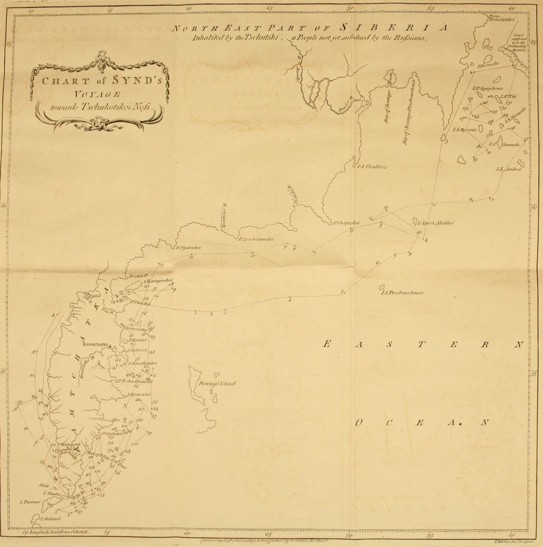 Chart of Synd's Voyage toward Tschukotskoi Noss.
 The following year he sailed from Ukinski Point due East and North East, until he fell in with a cluster of islands[162] stretching between 61 and 62 degrees of latitude, and 195° and 202° longitude. These islands lie South East and East of the coast of the Tschutski; and several of them are situated very near the shore. Besides these small islands, he discovered also a mountainous coast lying within one degree of the coast of the Tschutski, between 64 and 66 North latitude; its most Western extremity was situated in longitude 38° 15´ from Ochotsk, or 199° 1´ from Fero. This island is laid down in his chart as part of the continent of America; but we cannot determine upon what proofs he grounds this representation, until a more circumstantial account of his voyage is communicated to the public. [Pg 301]
[Pg 302]Synd seems to have made but a short stay ashore. Instead of endeavouring to survey its coasts, or of steering more to the East, he almost instantly shaped his course due West towards the course of the Tschutski, then turned directly South and South West, until he came opposite to Chatyrskoi Noss. From that point he continued to coast the peninsula of Kamtchatka, doubled the cape, and reached Ochotsk in 1768.
[Pg 303]
No X.
Specimen of the Aleütian language.
| Sun | Agaiya |
| Moon | Tughilag |
| Wind | Katshik |
| Water | Tana |
| Fire | Kighenag |
| Earth hut | Oollae |
| Chief | Toigon |
| Man | Taiyaga |
| Wood | Yaga |
| Shield | Kuyak |
| Sea otter | Tscholota |
| Name of the nation. | Kanagist. |
| One | Tagatak |
| Two | Alag |
| Three | Kankoos |
| Four | Setschi |
| Five | Tshaw |
| Six | Atoo |
| Seven | Ooloo |
| Eight | Kapoé |
| Nine | Shiset |
| Ten. | Asok. |
[Pg 304]
No XI.
Attempts of the Russians to discover a North East passage—Voyages from Archangel towards the Lena—From the Lena towards Kamtchatka—Extract from Muller's account of Deschneff's voyage round Tschukotskoi Noss—Narrative of a voyage made by Shalauroff from the Lena to Shelatskoi Noss.
The only communication hitherto known between the Atlantic and Pacific Oceans, or between Europe and the East Indies, is made either by sailing round the Cape of Good Hope, or by doubling Cape Horn. But as both these navigations are very long and dangerous, the great object of several late European voyages has been turned towards the discovery of a North East or a North West passage. As this work is entirely confined to the Russian navigations, any disquisition concerning the North West passage is totally foreign to the purpose; and for the same reason in what relates to the North East, these researches extend only to the attempts of the Russians for the discovery of that passage.The advocates for the North East passage have divided that navigation into three principal parts; and by endeavouring to shew that these three parts have been[Pg 305] passed at different times, they conclude from thence, that the whole when taken collectively is practicable.
These three parts are, 1. from Archangel to the Lena; 2. from the Lena to Kamtchatka; 3. from Kamtchatka to Japan. With respect to the latter, the connection between the seas of Kamtchatka and Japan first appeared from some Japanese vessels, which were wrecked upon the coast of Kamtchatka in the beginning of this century; and this communication has been unquestionably proved from several voyages made by the Russians from Kamtchatka to Japan[163].
No one ever asserted that the first part from Archangel to the Lena was ever performed in one voyage; but several persons having advanced that this navigation has been made by the Russians at different times, it becomes necessary to examine the accounts of the Russian voyages in those seas.
Voyages from Archangel to the Yenisèi.
In 1734 lieutenant Morovieff sailed from Archangel toward the river Oby; and got no farther the first year than the mouth of the Petchora. The next summer he passed through the straits ef Weygatz into the sea of Kara; and coasted along the Eastern side of that sea, as high as latitude 72° 30´, but did not double the promontory which separates the sea of Kara from the Bay of[Pg 306] Oby. In 1738, the lieutenants Malgyin and Skurakoff doubled that promontory with great difficulty, and entered the bay of Oby. During these expeditions the navigators met with great dangers and impediments from the ice. Several unsuccessful attempts were made to pass from the bay of Oby to the Yenisèi, which was at last effected, in 1738, by two vessels commanded by lieutenants Offzin and Koskeleff. |Unsuccessful Attempt to pass from the Yenisèi to the Lena.| The same year the pilot Feodor Menin sailed from the Yenisèi rowards the Lena:he steered North as high as lat. 73°. 15´. and when he came to the mouth of the Piasida he was stopped by the ice; and finding it impossible to force a passage, he returned to the Yenisèi[164].
Voyage of Prontshistsheff from the Lena towards the Yenisèi.
July, 1735, lieutenant Prontshistsheff sailed from Yakutsk up the Lena to its mouth, in order to pass from thence by sea to the Yenisèi. The Western mouths of the Lena were so choaked up with ice, that he was obliged to pass through the most Easterly one; and was prevented by contrary winds from getting out until the 13th of August. Having steered North West along the islands which lie scattered before the mouths of the Lena, he found himself in lat. 70° 4´. He saw much ice to the North and North East; and observed ice-mountains from twenty-four to sixty feet in height. He steered betwixt the ice, which in no place left a free channel of[Pg 307] greater breadth than an hundred or two hundred yards. The vessel being much damaged, on the 1st of September he ran up the mouth of the Olenek, which, according to his estimation, lies in 72° 30´, near which place he passed the winter[165].He got out of the Olenek the beginning of August in the following year; and arrived on the third at the mouth of the Anabara, which he found to lie in lat. 73° 1´. There he continued until the 10th, while some of the crew went up the country in search of some mines. On the 10th he proceeded on his voyage: before he reached the mouth of the Chatanga he was so entirely surrounded and hemmed in with ice, that it was not without great difficulty and danger he was able to get loose. He then observed a large field of ice stretching into the sea, on which account he was obliged to continue near the shore, and to run up the Chatanga. The mouth of this river was in lat 74° 9´. From thence he bent his course mostly Northward along the shore, until he reached the mouth of the Taimura on the 18th. He then proceeded further, and followed the coast towards the Piasida. Near the shore were several small islands, between which and the land the ice was immovably fixed. He then directed his course toward the sea, in order to pass round the[Pg 308] chain of islands. At first he found the sea more free to the North of the islands, while he observed much ice lying between them. He came at length to the last island, situated in lat. 77° 25´. Between this island and the shore, as well as on the other side of the island which lay most to the North, the ice was firm and immovable. |Prevented by a Chain of Islands and the Ice from getting to the Yenisèi| He attempted however to steer still more to the North; and having advanced about six miles, he was prevented by a thick fog from proceeding: this fog being dispersed, he saw on each side, and before him, nothing but ice; that towards the sea was not fixed; but the accumulated masses were all so close, that the smallest vessel could not have worked its way through. Still attempting however to pass to the North; he was forced by the ice N. E. Apprehensive of being hemmed in, he returned to the Taimura; and from thence got, with much difficulty and danger, to the Olenek, on the 29th of August.
This narrative of Prontshistsheff's expedition is extracted from the account of professor[166] Gmelin: according to Mr. Muller[167], who has given a cursory relation of the same voyage, Prontshistsheff did not quite reach the mouth of the Taimura; for he there found the chain of islands stretching from the continent far into the sea. The channels between the islands were so choaked up[Pg 309] with ice, that it was impossible to force a passage: after steering as high as lat. 77° 25´, he found such a plain of fixed ice before him, that he had no prospect of getting any farther. Accordingly he returned to the Olenek.
Another attempt was made to pass from the Lena to the Yenisèi in 1739, by Chariton Laptieff, with equal bad success; and he relates, that between the rivers Piasida and Taimura, a promontory stretches into the sea which he could not double, the sea being entirely frozen up before he could pass round[168].
Cape between the Rivers Chatanga and Piasida never yet doubled.
From all these circumstances we must collect, that the whole space between Archangel and the Lena has never yet been navigated; for in going East from the Yenisèi the Russians could get no farther than the mouth of the Piasida; and, in coming West from the Lena, they were stopped, according to Gmelin, North of the Piasida; and, according to Muller, East of the Taimura.The Russians, who sail almost annually from Archangel, and other towns, to Nova Zemla, for the purpose of catching sea-horses, seals, and white bears, make[Pg 310] to the Western Coast; and no Russian vessel has ever passed round its North Eastern extremity[169].
[Pg 311]
Attempts of the Russians to pass from the Lena to Kamtchatka.
The navigation from the Lena to Kamtchatka now remains to be considered. If we may believe some authors,[Pg 312] this navigation has been open for above a century and an half; and several vessels have at different times[Pg 313] passed round the North Eastern extremity of Asia. But if we consult the Russian accounts, we shall find, that frequent expeditions have been unquestionably made from the Lena to the Kovyma; but that the voyage from the Kovyma round Tschukotskoi Noss, into the Eastern ocean, has been performed but once. According to Mr. Muller, this formidable cape was doubled in the year 1648. The material incidents of this remarkable voyage are as follow.
Narrative of Deshneff's voyage round Tschukotskoi-Noss.
In 1648 seven kotches or vessels sailed from the mouth or the river Kovyma[170], in order to penetrate into the Eastern Ocean. Of these, four were never more heard of: the remaining three were commanded by Simon Deshneff, Gerasim Ankudinoff, two chiefs of the Cossacs, and Fedot Alexeeff, the head of the Promyshlenics. Deshneff and Ankudinoff quarrelled before their[Pg 314] departure: this dispute was owing to the jealousy of Deshneff, who was unwilling that Ankudinoff should share with him the honour, as well as the profits, which might result from the expected discoveries. Each vessel was probably manned with about thirty persons; Ankudinoff's, we certainly know, carried that number. Deshneff promised before-hand a tribute of seven fables, to be exacted from the inhabitants on the banks of Anadyr; so sanguine were his hopes of reaching that river. This indeed he finally effected; but not so soon, nor with so little difficulty, as he had presumed.On the 20th of June, 1648, the three vessels sailed upon this remarkable expedition from the river Kovyma. Considering the little knowledge we have of the extreme regions of Asia, it is much to be regretted, that all the incidents of this voyage are not circumstantially related. Deshneff[171], in an account of his expedition sent to[Pg 315] Yakutsk, seems only as it were accidentally to mention his adventures by sea: he takes no notice of any occur[Pg 316]rence until he reached the great promontory of the Tschutski; no obstructions from the ice are mentioned, and probably there were none; for he observes upon another occasion, that the sea is not every year so free[Pg 317] from ice as it was at this time. He commences his narrative with a description of the great promontory: "It is," says he, "very different from that which is situated West of the Kovyma, near the river Tschukotskia. It lies between North and North East, and bends, in a circular direction, towards the Anadyr. It is distinguished on the Russian (namely, the Western) side, by a rivulet which falls into the sea, close to which the Tschutski have raised a pile, like a tower, with the bones of whales. Opposite the promontory, (it is not said on which side), are two islands, on which he observed people of the nation of the Tschutski, who had pieces of the sea-horse tooth thrust into holes made in their lips. With a good wind it is possible to sail from this promontory to the Anadyr in three days; and the journey by land may be performed in the same space of time, because the Anadyr falls into a bay." Ankudinoff's kotche was wrecked on this promontory, and the crew was distributed on board the two remaining vessels. On the 20th of September Deshneff and Fedot Alexeef went on shore, and had a skirmish with the Tschutski, in which Alexeef was wounded. The two vessels soon afterwards lost sight of each other, and never again rejoined. Deshneff was driven about by tempestuous winds until October, when he was shipwrecked (as it appears from circumstances), considerably to the South of the Anadyr, not far from the river Olutora.[Pg 318] What became of Fedot Alexeff and his crew will be mentioned hereafter. Deshneff and his companions, who amounted to twenty-five persons, now sought for the Anadyr; but being entirely unacquainted with the country, ten weeks elapsed before they reached its banks at a small distance from its mouth: here he found neither wood nor inhabitants, &c.
The following year he went further up the river, and built Anadirskoi Ostrog: here he was joined by some Russians on the 25th of April, 1650, who came by land from the river Kovyma. In 1652, Deshneff having constructed a vessel, sailed down the Anadyr as far as its mouth, and observed on the North side a sand bank, which stretched a considerable way into the sea. A sand bank of this kind is called, in Siberia, Korga. Great numbers of sea-horses were found to resort to the mouth of the Anadyr. Deshneff collected several of their teeth, and thought himself amply compensated by this acquisition for the trouble of his expedition. In the following year, Deshneff ordered wood to be felled for the purpose of constructing a vessel, in which he proposed sending the tribute which he had collected by sea to Yakutsk[172]. But this design was laid aside from the[Pg 319] want of other materials. It was also reported, that the sea about Tschukotskoi Noss was not every year free from ice.
Another expedition was made in 1654 to the Korga, for the purpose of collecting sea-horse teeth. A Cossac, named Yusko Soliverstoff, was one of the party, the same who had not long before accompanied the Cossac Michael Stadukin, upon a voyage of discovery in the Frozen Sea. This person was sent from Yakutsk to collect sea-horse teeth, for the benefit of the crown. In his instructions mention is made of the river Yentshendon, which falls into the bay of Penshinsk, and of the Anadyr; and he was ordered to exact a tribute from the inhabitants dwelling near these rivers; for the adventures of Deshneff were not as yet known at Yakutsk. This was the occasion of new discontents. Soliverstoff claimed to himself the discovery of the Korga, as if he had sailed to that place in his voyage with Stadukin in 1649. Deshneff, however, proved that Soliverstoff had not even reached Tschukotskoi Noss, which he describes as nothing but bare rock, and it was but too well known to him, because the vessel of Ankudinoff was ship-wrecked there. "Tschukotskoi Noss," adds Deshneff, "is not the first promontory which presents itself under the name of Svatoi Noss[173]. It is known by the[Pg 320] two islands situated opposite to it, whose inhabitants (as is before-mentioned) place pieces of the sea-horse tush into holes made in their lips. Deshneff alone had seen these people, which neither Stadukin nor Soliverstoff had pretended to have done: and the Korga, or sand-bank, at the mouth of the river Anadyr, was at some distance from these islands."
While Deschneff was surveying the sea-coast, he saw in an habitation belonging to some Koriacs a woman of Yakutsk, who, as he recollected, belonged to Fedot Alexieff. Upon his enquiry concerning the fate of her master, she replied, "that Fedot and Gerasim (Ankudinoff) had died of the scurvy; that part of the crew had been slain; that a few had escaped in small vessels, and have never since been heard off." Traces of the latter were afterwards found in the peninsula of Kamt[Pg 321]chatka; to which place they probably arrived with a favourite wind, by following the coast, and running up the Kamtchatka river.
When Volodimir Atlassoff, in 1697, first entered upon the reduction of Kamtchatka, he found that the inhabitants had already some knowledge of the Russians. A common tradition still prevails amongst them, that long before the expedition of Atlassoff, one[174] Fedotoff (who was probably the son of Fedot Alexeeff) and his companions had resided amongst them, and had intermarried with the natives. They still shew the spot where the Russian habitations stood; namely, at the mouth of the small river Nikul which falls into the Kamtchatka river, and is called by the Russians Fedotika. Upon Atlassoff's arrival none of the first Russians remained. They are said to have been held in great veneration, and almost deified by the inhabitants, who at first imagined that no human power could hurt them, until they quarrelled amongst themselves, and the blood was seen to flow from the wounds which they gave each other: and upon a separation taking place between the Russians, part of them had been killed by the Koriacs, as they were going to the sea of Penshinsk, and the remainder by the Kamtchadals. The river Fedotika falls into the Southern side of[Pg 322] the Kamtchatka river about an hundred and eighty versts below Upper Kamtchatkoi Ostrog. At the time of the first expedition to Kamtchatka, in 1697, the remains of two villages still subsisted, which had probably been inhabited by Fedotoff and his companions: and no one knew which way they came into the peninsula, until it was discovered from the archives of Yakutsk in 1636. [175] No other navigator, subsequent to Deshneff, has ever pretended to have passed the North Eastern extremity of[Pg 323] Asia, notwithstanding all the attempts which have been made to accomplish this passage, as well from[176] Kamtchatka as from the Frozen Ocean.
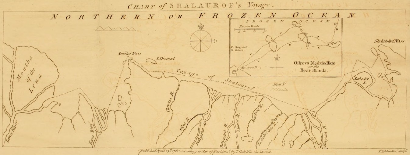 Chart of Shalaurof's Voyage.
Voyage of Shalauroff.
Shalauroff, having constructed a shitik at his own expence, went down the Lena in 1761. He was accompanied by an exiled midshipman, whom he had found at Yakutsk, and to whom we are indebted for[Pg 324] the chart of this expedition. Shalauroff got out of the Southern mouth of the Lena in July, but was so much embarrassed by the ice, that he ran the vessel into the mouth of the Yana, where he was detained by the ice until the 29th of August, when he again set sail. Being prevented by the ice from keeping the open sea, he coasted the shore; and, having doubled Svatoi-Noss on the 6th of September, discovered at a small distance, out at sea, to the North, a mountainous land, which is probably some unknown island in the Frozen Sea. He was employed from the 7th to the 15th in getting through the strait between Diomed's island and the coast of Siberia; which he effected, not without great difficulty. From the 16th he had a free sea and a fair S. W. wind, which carried them in 24 hours beyond the mouth of the Indigirka. The favourable breeze continuing, he passed on the 18th the Alasca. Soon afterwards, the vessel approaching too near the shore was entangled amongst vast floating masses of ice, between some islands[177] and[Pg 325] the main land. |Winters at the Mouth of the Kovyma.| And now the late season of the year obliged Shalauroff to look out for a wintering place; he accordingly ran the vessel into one of the mouths of the river Kovyma, where she was laid up. The crew immediately constructed an hut, which they secured with a rampart of frozen snow, and a battery of the small guns. The wild rein-deers resorted to this place in large herds, and were shot in great plenty from the enclosure. Before the setting in of winter, various species of salmon and trout came up the river in shoals: these fish afforded the crew a plentiful subsistence, and preserved them from the scurvy[178].
Departure from thence in July.
The mouth of the Kovyma was not freed from ice before the 21st of July, 1762, when Shalauroff again[Pg 326] put to sea, and steered until the 28th N. E. by N. E. 1/4 E. Here he observed the variation of the compass ashore, and found it to be 11° 15´´ East. The 28th a contrary wind, which was followed by a calm, obliged him to come to an anchor, and kept him stationary until the 10th of August, when a favourable breeze springing up he set sail; he then endeavoured to steer at some distance from shore, holding a more Easterly course, and N. E. by E. But the vessel was impeded by large bodies of floating ice, and a strong current, which seemed to bear Westward at the rate of a verst an hour. These circumstances very much retarded his course. On the 18th, the weather being thick and foggy, he found himself unexpectedly near the coast with a number of ice islands before him, which on the 19th entirely surrounded and hemmed in the vessel. He continued in that situation, and in a continual fog, until the 23d, when he got clear, and endeavoured by steering N. E. to regain the open sea, which was much less clogged with ice than near the shore. He was forced however, by contrary winds, S. E. and E. among large masses of floating ice. This drift of ice being passed, he again stood to the N. E. in order to double Shelatskoi Noss[179]; but before he could reach the islands[Pg 327] lying near it, he was so retarded by contrary winds, that he was obliged, on account of the advanced season, to search for a wintering place. |Not being able to double Shelatskoi Noss returns towards the Kovyma.| He accordingly sailed South towards an open bay, which lies on the West side of Shelatskoi Noss, and which no navigator had explored before him. He steered into it on the 25th, and got upon a shoal between a small island, and a point of land which juts from the Eastern coast of this bay. Having got clear with much difficulty, he continued for a short time a S. E. course, then turned S. W. He then landed in order to discover a spot proper for their winter residence; and found two small rivulets, but neither trees nor drift wood. The vessel was towed along the Southerly side of the bay as far as the island Sabadèi. On the 5th of September, he saw some huts of the Tschutski close to the narrow channel between Sabadèi and the main land; but the inhabitants fled on his approach.Not having met with a proper situation, he stood out to sea, and got round the island Sabadèi on the 8th, when he fastened the vessel to a large body of ice, and was carried along by a current towards W. S. W. at the rate of five versts an hour. On the 10th, he saw far to the N. E. by N. a mountain, and steered the 11th and 12th towards his former wintering place in the river Kovyma. |Winters a second Time at the Kovyma, and returns to the Lena.| Shalauroff proposed to have made[Pg 328] the following year another attempt to double Shelatskoi Noss; but want of provision, and the mutiny of the crew, forced him to return to the Lena in 1763. It is worth remarking, that during his whole voyage he found the currents setting in almost uniformly from the East. Two remarkable rocks were observed by Shalauroff near the point where the coast turns to the N. E. towards the channel which separates the island Sabadèi from the continent; these rocks may serve to direct future navigators: one is called Saetshie Kamen, or Hare's Rock, and rises like a crooked horn; the other Baranèi Kamen, or Sheep's Rock; it is in the shape of a pear, narrower at the bottom than at top, and rises twenty-nine yards above high-water mark.
Second Expedition of Shalauroff.
Shalauroff, who concluded from his own experience, that the attempt to double Tschukotskoi Noss, though difficult, was by no means impracticable, was not discouraged by his former want of success from engaging a second time in the same enterprize: he accordingly fitted out the same shitik, and in 1764 departed as before from the river Lena. We have no positive accounts of this second voyage; for neither Shalauroff or any of his crew have ever returned. The following circumstances lead us to conclude, that both he and his crew were killed near the Anadyr by the Tschutski, about the third year after their departure from the Lena.[Pg 329] About that time the Koriacs of the Anadyr refused to take from the Russians the provision of flour, which they are accustomed to purchase every year. Enquiry being made by the governor of Anadirsk, he found that they had been amply supplied with that commodity by the Tschutski. The latter had procured it from the plunder of Shalauroff's vessel, the crew of which appeared to have perished near the Anadyr. |No Account of this Expedition, he and his Crew being killed by the Tschutski.| From these facts, which have been since confirmed by repeated intelligence from the Koriacs and Tschutski, it has been asserted, that Shalauroff had doubled the N. E. cape of Asia. But this assertion amounts only to conjecture; for the arrival of the crew at the mouth of the Anadyr affords no decisive proof that they had passed round the Eastern extremity of Asia; for they might have penetrated to that river by land, from the Western side of Tschukotskoi-Noss.In reviewing these several accounts of the Russian voyages in the Frozen Sea, as far as they relate to a North East passage, we may observe, that the cape which stretches to the North of the Piasida has never been doubled; and that the existence of a passage round Tschukotskoi Noss rests upon the single authority of Deshneff. Admitting however a practicable navigation round these two promontories, yet when we consider the difficulties and dangers which the Russians en[Pg 330]countered in those parts of the Frozen Sea which they have unquestionably sailed through; how much time they employed in making an inconsiderable progress, and how often their attempts were unsuccessful: when we reflect at the same time, that these voyages can only be performed in the midst of a short summer, and even then only when particular winds drive the ice into the sea, and leave the shores less obstructed; we shall reasonably conclude, that a navigation, pursued along the coasts in the Frozen Ocean, would probably be useless for commercial purposes.
A navigation therefore in the Frozen Ocean, calculated to answer any end of general utility, must (if possible) be made in an higher latitude, at some distance from the shores of Nova Zemla and Siberia. And should we even grant the possibility of sailing N. E. and East of Nova Zemla, without meeting with any insurmountable obstacles from land or ice; yet the final completion of a N. E. voyage must depend upon the existence of a free passage[180] between the coast of the Tschutski and the continent of America. But such dis[Pg 331]quisitions as these do not fall under the intention of this work, which is meant to state and examine facts, not to lay down an hypothesis, or to make theoretical enquiries[181].
[Pg 332]
APPENDIX II.
Tartarian rhubarb brought to Kiachta by the Bucharian Merchants—Method of examining and purchasing the roots—Different species of rheum which yield the finest rhubarb—Price of rhubarb in Russia—Exportation—Superiority of the Tartarian over the Indian rhubarb.
Tartarian, or Turkey, Rhubarb.
Europe is supplied with rhubarb from Russia and the East Indies. The former is generally known by the name of Turkey rhubarb, because we used to import it from the Levant in our commerce with the Turks, who procured it through Persia from the Bucharians. And it still retains its original name, although instead of being carried, as before, to Constantinople, it is now brought to Kiachta by the Bucharian merchants, and there disposed of to the Russians. This appellation is indeed the most general; but it is mentioned occasionally by several authors, under the different denominations of Russian, Tartarian, Bucharian, and Thibet, Rhubarb. This sort is exported from Russia in large roundish pieces, freed from the bark, with an hole through the middle: they are externally of a yellow colour, and when cut appear variagated with lively reddish streaks.[Pg 333]
Indian Rhubarb.
The other sort is called by the Druggists Indian Rhubarb; and is procured from Canton in longer, harder, heavier, more compact pieces, than the former; it is more astringent, and has somewhat less of an aromatic flavour; but, on account of its cheapness, is more generally used than the Tartarian or Turkey Rhubarb.
Tartarian Rhubarb procured at Kiachta.
The government of Russia has reserved to itself the exclusive privilege of purchasing rhubarb; it is brought to Kiachta by some Bucharian merchants, who have entered into a contract to supply the crown with that drug in exchange for furs. These merchants come from the town of Selin, which lies South Westward of the Koko-Nor, or Blue Lake toward Thibet. Selin, and all the towns of Little Bucharia; viz. Kashkar, Yerken, Atrar, &c. are subject to China.
The Rhubarb Plant grows upon the Mountains of Little Bucharia.
The best rhubarb purchased at Kiachta is produced upon a chain of rocks, which are very high, and for the most part destitute of wood: they lie North of Selin, and stretch as far as the Koko-Nor. The good roots are distinguished by large and thick stems. The Tanguts, who are employed in digging up the roots, enter upon that business in April or May. As fast as they take them out of the earth, they cleanse them from the soil, and hang them upon the neighbouring trees to dry, where[Pg 334] they remain until a sufficient quantity is procured: after which they are delivered to the Bucharian merchants. The roots are wrapped up in woollen sacks, carefully preserved from the least humidity; and are in this manner transported to Kiachta upon camels.The exportation of the best rhubarb is prohibited by the Chinese, under the severest penalties. It is procured however in sufficient quantities, sometimes by clandestinely mixing it with inferior roots, and sometimes by means of a contraband trade. The College of Commerce at Petersburg is solely empowered to receive this drug, and appoints agents at Kiachta for that purpose. Much care is taken in the choice; for it is examined, in the presence of the Bucharian merchants, by an apothecary commissioned by government, and resident at Kiachta. |Care taken in examining the roots at Kiachta.| All the worm-eaten roots are rejected; the remainder are bored through, in order to ascertain their soundness; and all the parts which appear in the least damaged or decayed are cut away. By these means even the best roots are diminished a sixth part; and the refuse is burnt, in order to prevent its being brought another year[182].
[Pg 335]
Different Species of Rhubarb.
Linnæus has distinguished the different species of rhubarb by the names Rheum Palmatum, R. Rhaphonticum,[183] R. Rhabarbarum, R. Compactum, and R. Ribes.Botanists have long differed in their opinions, which of these several species is the true rhubarb; and that question does not appear to be as yet satisfactorily cleared up. |Rheum Palmatum.| However, according to the notion which is most generally received, it is supposed to be the Rheum[184] Palmatum; the seeds of which were originally procured from a Bucharian merchant, and distributed to the principal botanists of Europe. Hence this plant has been cultivated with great success; and is now very common in all our botanical gardens. The learned doctor[185]Hope, professor of medicine and botany in the university of Edinburgh, having made trials of the powder of this root, in the same doses in which the foreign rhubarb is given, found no difference in its effects; and from thence conclusions have been drawn with great appearance of pro[Pg 336]bability, that this is the plant which produces the true rhubarb. But this inference does not appear to be absolutely conclusive; for the same trials have been repeated, and with similar success, upon the roots of the R. Rhaponticum and R. Rhabarbarum.
R. Rhaponticum.
The leaves of the R. Rhaponticum are round, and sometimes broader than they are long. This species is found abundantly in the loamy and dry deserts between the Volga and the Yaik[186], towards the Caspian Sea. It was probably from this sort that the name Rha, which is the Tartarian appellation of the river Volga, was first applied by the Arabian physicians to the several species of rheum. The roots however which grow in these warm plains are rather too astringent; and therefore ought not to be used in cases where opening medicines are required. The Calmucs call it Badshona, or a stomachic. The young shoots of this plant, which appear in March or April, are deemed a good antiscorbutic; and are used as such by the Russians. The R. Rhaponticum is not to be found to the West of the Volga. The seeds of this species produced at Petersburg plants of a much greater size than the wild ones: the leaves were large, and of a roundish cordated figure.[Pg 337]
R. Rhabarbarum.
The R. Rhabarbarum grows in the crevices of bare rocky mountains, and also upon gravelly soils: it is more particularly found in the high vallies of the romantic country situated beyond Lake Baikal. Its buds do not shoot before the end of April; and it continues in flower during the whole month of May. The stalks of the leaves are eaten raw by the Tartars: they produce upon most persons, who are unaccustomed to them, a kind of sphasmodic contraction of the throat, which goes off in a few hours; it returns however at every meal, until they become habituated to this kind of diet. The Russians make use of the leaves in their hodge-podge: accordingly, soups of this sort affect strangers in the manner above mentioned. In Siberia the stalk is sometimes preserved as a sweet-meat; and a custom prevails among the Germans of introducing at their tables the buds of this plant, as well as of the Rheum Palmatum, instead of cauli-flower.
R. Rhaponticum.
The R. Rhaponticum which commonly grows near the torrents has, as well as the R. Rhabarbarum of Siberia, the upper part of its roots commonly rotten, from too much moisture: accordingly, a very small portion of the lower extremity is fit for use. The Russian College of Physicians order, for the use of their military hospitals, large quantities of these roots to be dug up in Siberia, which are prescribed under the name of rhapontic. But the persons employed in digging and preparing it are so ill instructed for that purpose, that its[Pg 338] best juices are frequently lost. These roots ought to be drawn up in spring, soon after the melting of the snows, when the plant retains all its sap and strength; whereas they are not taken out of the ground before August, when they are wasted by the increase of the stem, and the expansion of the leaves. Add to this, that the roots are no sooner taken up, than they are immediately sliced in small pieces, and thus dried: by which means the medicinal qualities are sensibly impaired.
Method of drying the Roots of the R. Rhaponticum.
For the same roots, which in this instance were of such little efficacy, when dried with proper precaution, have been found to yield a very excellent rhubarb. The process observed for this purpose, by the ingenious Mr. Pallas, was as follows: The roots, immediately after being drawn out, were suspended over a stove, where being gradually dried, they were cleansed from the earth: by these means, although they were actually taken up in autumn, they so nearly resembled the best Tartarian rhubarb in colour, texture, and purgative qualities, that they answered, in every respect, the same medicinal purposes.A German apothecary, named Zuchert, made similar trials with the same success, both on the Rheum Rhabarbarum and R. Rhaponticum, which grow in great perfection on the mountains in the neighbourhood of Nershinsk. |Plantation of Rhubarb in Siberia.| He formed plantations of these herbs on[Pg 339] the declivity of a rock[187], covered with one foot of good mould, mixed with an equal quantity of sand and gravel. If the summer proved dry, the plants were left in the ground; but if the season was rainy, after drawing out the roots he left them for some days in the shade to dry, and then replanted them. By this method of cultivation he produced in seven or eight years very large and sound roots, which the rock had prevented from penetrating too deep; and when they were properly dried, one scruple was as efficacious as half a drachm of Tartarian rhubarb.
The Roots of the R. Rhaponticum and R. Rhubarbarum, equal in their Effects to the Tartarian Rhubarb.
From the foregoing observations it follows, that there are other plants, besides the Rheum Palmatum, the roots whereof have been found to be similar both in their appearance and effects, to what is called the best rhubarb. And indeed, upon enquiries made at Kiachta concerning the form and leaves of the plant which produces that drug, it seems not to be the R. Palmatum, but a species with roundish scolloped leaves, and most probably the R. Rhaponticum: for Mr. Pallas, when he was at Kiachta, applied for information to a Bucharian merchant of Selin-Chotton, who now supplies the crown with rhu[Pg 340]barb; and his description of that plant answered to the figure of the Rheum Rhaponticum. The truth of this description was still further confirmed by some Mongol travellers who had been in the neighbourhood of the Koko-Nor and Thibet; and had observed the rhubarb growing wild upon those mountains.
The true Rhubarb probably procured from different Species of Rheum.
The experiments also made by Zuchert and others, upon the roots of the R. Rhabarbarum and R. Rhaponticum, sufficiently prove, that this valuable drug was procured from those roots in great perfection. the seeds of the Rheum Palmatum were received from the father of the above-mentioned Bucharian merchant as taken from the plant which furnishes the true rhubarb, we have reason to conjecture, that these three species, viz. R. Palmatum, R. Rhaponticum, and R. Rhabarbarum, when found in a dryer and milder alpine climate, and in proper situations, are indiscriminately drawn up; whenever the size of the plant seems to promise a fine root. And perhaps the remarkable difference of the rhubarb, imported to Kiachta, is occasioned by this indiscriminate method of collecting them. Most certain it is, that these plants grow wild upon the mountains, without the least cultivation; and those are esteemed the best which are found near the Koko-Nor, and about the sources of the river Koango.[Pg 341]
Formerly the exportation of rhubarb was confined to the crown of Russia; and no persons but those employed by government were allowed the permission of sending it to foreign countries; this monopoly however has been taken off by the present empress, and the free exportation of it from St. Petersburg granted to all persons upon paying the duty. It is sold in the first instance by the College of Commerce for the profit of the Sovereign; and is preserved in their magazines at St. Petersburg. The current price is settled every year by the College of Commerce.
Price of Rhubarb in Russia.
It is received from the Bucharian merchants at Kiachta in exchange for furs; and the prime cost is rated at 16 roubles per pood. By adding the pay of the commissioners who purchase it, and of the apothecary who examines it, and allowing for other necessary expences, the value of a pood at Kiachta amounts to 25 roubles; add to this the carriage from the frontiers to St. Petersburg, and it is calculated that the price of a pood stands the crown at 30 roubles. The largest exportation of rhubarb ever known from Russia, was made in the year 1765, when 1350 pood were exported, at 65 roubles per pood.[Pg 342]
Exportation of Rhubarb from St. Petersburg.
EXPORTATION of RHUBARB
From St. Petersburg.
From St. Petersburg.
| In 1777, 29 poods 13 pounds | at 76-1/4 Dutch[188] dollars, or 91 roubles, 30 copecs per pood. |
| In 1778, 23 poods 7 pounds, | at 80 ditto, or 96 roubles. |
Superiority of the Tartarian over the Indian Rhubarb.
The superiority of this Tartarian Rhubarb, over that procured from Canton, arises probably from the following circumstances.1. The Southern parts of China are not so proper for the growth of this plant, as the mountains of Little Bucharia.
2. There is not so exact an examination made in receiving it from the Chinese at Canton, as from the[Pg 343] Bucharians at Kiachta. For the merchants, who purchase this drug at Canton, are obliged to accept it in the gross, without separating the bad roots, and cutting away the decayed parts, as is done at Kiachta.
3. It is also probable, that the long transport of this drug by sea is detrimental to it, from the humidity which it must necessarily contract during so long a voyage.
[Pg 344]
TABLE of LONGITUDE and LATITUDE.
Table of Longitude and Latitude.
For the convenience of the Reader, the following Table exhibits in one point of view the longitude and latitude of the principal places mentioned in this performance. Their longitudes are estimated from the first meridian of the Isle of Fero, and from that of the Royal Observatory at Greenwich. The longitude of Greenwich from Fero is computed at 17° 34´ 45´´. The longitude of the places marked * has been taken from astronomical observations.| Latitude. | Longitude. | ||||||||
| Fero. | Greenwich. | ||||||||
| D. | M. | S. | D. | M. | S. | D. | M. | ||
| * Petersburg | 59 | 56 | 23 | 48 | 0 | 0 | 30 | 25[190] | |
| * Moscow | 55 | 45 | 45 | 55 | 6 | 30 | 37 | 31 | |
| * Archangel | 64 | 33 | 24 | 56 | 15 | 0 | 38 | 40 | |
| * Tobolsk | 58 | 12 | 22 | 85 | 40 | 0 | 68 | 26 | |
| * Tomsk | 56 | 30 | 0 | 102 | 50 | 0 | 85 | 15 | |
| * Irkutsk | 52 | 18 | 15 | 122 | 13 | 0 | 104 | 38 | |
| * Selenginsk | 51 | 6 | 0 | 124 | 18 | 30 | 106 | 44 | |
| Kiachta | 35 | 0 | 0 | 124 | 18 | 0 | 106 | 43 | |
| * Yakutsk | 62 | 1 | 50 | 147 | 0 | 0 | 129 | 25 | |
| * Ochotsk | 59 | 22 | 0 | 160 | 7 | 0 | 142 | 32 | |
| * Bolcheresk | 52 | 55 | 0 | 174 | 13 | 0 | 156 | 38 | |
| * Port of St. Peter and Paul | 53 | 1 | 0 | 176 | 10 | 0 | 158 | 36 | |
| Eastern Extremity of Siberia | 66 | 0 | 0 | 200 | 0 | 0 | 182 | 25 | |
| Unalashka { | According to the general map of Russia | 58 | 0 | 0 | 223 | 0 | 0 | 205 | 25 |
| According to the chart of Krenitzin & Levashoff | 53 | 30 | 0 | 205 | 30 | 0 | 187 | 55 | |
FOOTNOTES:
[1] The title of the book is, Neue Nachrichten von denen Neuendeckten Insuln in der See zwischen Asia und Amerika aus mitgetheilten Urkunden und Auszuegen versasset von J. L. S.
[2] The journals of Krenitzin and Levasheff, the short account of Synd's voyage, and the narrative of Shalauroff's expedition, No I. IX. XI.
[3] The fathom for measuring the depth of water is the same as the English fathom = 6 feet.
[4] See p. 286.
[5] S. R. G. V. III. p. 72.
[6] Journal of St. Petersburg for April 1777.
[7] Journal of St. Petersburg.
[8] In 1772 there were only 570 head of cattle upon the whole Peninsula. A cow sold from 50 to 60 Roubles, an ox from 60 to 100. A pound of fresh beef sold upon an average for 12-1/2 copecs. The excessive dearness of this price will be easily conceived, when it is known, that at Moscow a pound of beef sells for about three copecs. Journ. St. Petersb.
[9] Georgi Reise Tom. I. p. 23, & seq. Journal of St. Petersburg.
[10] See Part II. Chap. III.
[11] S.R.G. III. p. 530.
[12] Journal St. Petersburg.
[13] Pallas Reise. Part III. p. 137.
[14] Pallas Reise.
[15] S. R. G. V. III.
[16] The reader will find an account of this conquest by Yermac in Part II. Chap. I.
[17] There seems a want of connection in this place, which will be cleared up by considering, that, by the conquest of Siberia, the Russians advanced to the shores of the Eastern Ocean, the scene of the discoveries here alluded to.
[18] Beering had already made several expeditions in the sea of Kamtchatka, by orders of the crown, before he undertook the voyage mentioned in the text.
In 1728, he departed from the mouth of the Kamtchatka river, in company with Tschirikoff. The purport of this voyage was to ascertain, whether the two Continents of Asia and America were separated; and Peter I. a short time before his death, had drawn up instructions with his own hand for that purpose. Beering coasted the Eastern shore of Siberia as high as latitude 67° 18´; but made no discovery of the opposite Continent.
In 1729, he set sail again for the prosecution of the same design; but this second attempt equally failed of success.
In 1741, Beering and Tschirikoff went out upon the celebrated expedition (alluded to in the text, and which is so often mentioned in the course of this work) towards the coasts of America. This expedition led the way to all the important discoveries since made by the Russians.
Beering's vessel was wrecked in December of the same year; and Tschirikoff landed at Kamtchatka on the 9th of October, 1742.
S. R. G. III. Nachrichten von See Reisen, &c. and Robertson's History of America, Vol. I. p. 273, & seq.
[19] The author reckons, throughout this treatise, the longitude from the first meridian of the isle of Fero. The longitude and latitude, which he gives to the Fox Islands, corresponds exactly with those in which they are laid down upon the General Map of Russia. The longitude of Beering's, Copper Island, and of the Aleütian Isles, are somewhat different. See Advertisement relating to the Charts, and also Appendix I. No IV.
[20] The author here alludes to the secret expedition of Captain Krenitzin and Levaheff, whose journal and chart were sent, by order of the Empress of Russia, to Dr. Robertson. See Robertson's History of America, Vol. I. p. 276 and 460. See Appendix I. No I.
[21] Mr. Muller formerly conjectured, that the coast of the sea of Ochotsk stretched South-west towards the river Ud; and from thence to the mouth of the Amoor South-east: and the truth of this conjecture had been since confirmed by a coasting voyage made by Captain Synd.
[25] These are the same islands which are called, by Mr. Stæhlin, Anadirsky Islands, from their supposed vicinity to the river Anadyr. See Appendix I. No V.
[28] This error is however so small, and particularly with respect to the more Eastern coasts and islands, as laid down in Beering's chart, such as Cape Hermogenes, Toomanoi, Shumaghin's Island, and mountain of St. Dolmar, that if they were to be placed upon the general map of Russia, which is prefixed to this work, they would coincide with the very chain of the Fox Islands.
[29] Mr. Muller has already arranged and put in order several of the journals, and sent them to the board of admiralty at St. Petersburg, where they are at present kept, together with the charts of the respective voyages.
[30] A German copy of the treatise alluded to in the text, was sent, by its author, Mr. Stæhlin Counsellor of State to the Empress of Russia, to the late Dr. Maty; and it is mentioned, in the Philosophical Transactions for 1774, under the following title: "A New Map and Preliminary Description of the New Archipelago in the North, discovered a few Years ago by the Russians in the N. E. beyond Kamtchatka." A translation of this treatise was published the same year by Heydinger.
[31] The small group of islands lying S. E. of Beering's Island, are the real Aleütian isles: they are sometimes called the Nearest Aleütian Islands; and the Fox Islands the Furthest Aleütian Isles.
[32] It may be necessary to inform the reader, that, in this and the two following chapters, some circumstances are occasionally omitted, which are to be found in the original. These omissions relate chiefly to the names of some of the partners engaged in the equipments, and to a detail of immaterial occurrences prior to the actual departure of the vessels.
[33] The author here remarks in a note, that the proper names of the islanders mentioned in this place, and in other parts, bear a surprising resemblance, both in their sound and termination, to those of the Greenlanders.
[34] See Chap. II.
[35] See Chap. V.
[36] Matten aus einem gevissen Krautgeflochten.
[37] Heracleum.
[38] Rubus Chamæmorus—Empetrum—Myrtillus—Sorbus.
[39] See chap. III.
[40] See chap. IV.
[41] Atach and Atchu are two names for the same island, called also by the Russians Goreloi or Burnt Island.
[42] This is probably the same island which is laid down in Krenitzin's chart under the name of Alaxa.
[43] It appears in the last chapter of this translation, that the islanders are accustomed to glue on the point of their darts with blood; and that this was the real motive to the practice mentioned in the text.
[44] The author adds, that these turbot [paltus] weigh occasionally seven or eight pood.
[45] These are the six Islands described by Mr. Stæhlin in his description of the New Archipelago. See Appendix I. No. V.
[46] Empetrum, Vaccin. Uliginosum, Sanguisorba, & Bistorta.
[47] Colymbus Troile, Alca Arctica.
[48] Chap. X.
[49] See the following Chapter.
[50] These Russians were well known to several persons of credit, who have confirmed the authenticity of this relation. Among the rest the celebrated naturalist Mr. Pallas, whose name is well known in the literary world, saw Bragin at Irkutsk: from him he had a narrative of their adventures and escape; which, as he assured me, perfectly tallied with the above account, which is drawn from the journal of Korelin.
[51] This is the fourth vessel which sailed in 1762. As the whole crew was massacred by the savages, we have no account of the voyage. Short mention of this massacre is occasionally made in this and the following chapters.
[52] See the following Chapter.
[53] Chap. XI.
[54] The author repeats here several circumstances which have been mentioned before, and many of them will occur again: but my office as a translator would not suffer me to omit them.
[55] These and several other ornaments of a similar kind are preserved in the cabinet of curiosities at the Academy of Sciences of St. Petersburg: a cabinet which well merits the attention of the curious traveller; for it contains a large collection of the dresses of the Eastern nations. Amongst the rest one compartment is entirely filled with the dresses, arms, and implements, brought from the new discovered islands.
[56] Although this conjecture is probable, yet, when the reader recollects that the island Alaksu is said to contain rein-deer, he will perceive that the inhabitants of Kadyak might have been supplied with the skins of that animal from thence. See p. 68.
[57] Kadyak is not laid down upon any chart of the new discovered islands: for we have no chart of Glottoff's voyage; and no other Russian navigator touched at that island.
[58] See Chap. VI.
[59] See the preceding Chapter.
[60] Chap. XI.
[61] Lief man bey nordwest wind auf den curs zu 2 bis 3 knoten.
[62] Von gesicht sind sie platt undweiss durchgaengig mit schwarzen haaren.
[63] The original in this passage is somewhat obscure. Die maenner scheeren mit einem Scharfen Stein oder messer den Umkreiss des haarkopfs und die platte, und lassen die haare um die krone des kopfs rundum ueberhangen.
[64] In the last chapter it is said that there are sorcerers among them.
[65] The expression in the original is "Schlagen auf grossen platten handpauken," which, being literally translated, signifies "They beat upon large flat hand-kettle drums of different sounds."
By the accounts which I procured at Petersburg, concerning the form of these drums, they seem to resemble in shape those made use of by the sorcerers of Kamtchatka, and are of different sizes. I had an opportunity of seeing one of the latter at the Cabinet of Curiosities. It is of an oval form, about two feet long and one broad: it is covered only at one end like the tambour de basque, and is worn upon the arm like a shield.
By the accounts which I procured at Petersburg, concerning the form of these drums, they seem to resemble in shape those made use of by the sorcerers of Kamtchatka, and are of different sizes. I had an opportunity of seeing one of the latter at the Cabinet of Curiosities. It is of an oval form, about two feet long and one broad: it is covered only at one end like the tambour de basque, and is worn upon the arm like a shield.
[66] Called in a former journal Atchu, p. 63.
[68] S. R. G. VI. p. 199-211. Fis. Sib. Ges. Tom. I.
[69] S. R. G. VI. p. 220-223. Fis. Sib. Ges. p. 182.
[70] S. R. G. VI. p. 217.
[71] S. R. G. VI. p. 232. Fis. Sib. Ges. I. p. 185.
[72] S. R. G. VI. p. 233.
[73] Several authors have supposed the name of Siberia to derive its origin from this fortress, soon after it was first taken by the Russians under Yermac. But this opinion is advanced without sufficient foundation; for the name of Sibir was unknown to the Tartars, that fort being by them called Isker. Besides, the Southern part of the province of Tobolsk, to which the name of Siberia was originally applied, was thus denominated by the Russians before the invasion of Yermac. This denomination probably first came from the Permians and Sirjanians, who brought the first accounts of Siberia to the Russians.
S. R. G. VI. p. 180.
[74] S. R. G. VI. p. 180.
[75] Fis. Sib. Ges. I. p. 187.
[76] S.R.G. VI. p. 243-248-262.
[77] A The place where the Tartar army lay encamped was called Tschuvatch: it is a neck of land washed by the Irtish, near the spot where the Tobob falls into that river. Fis. Sib. Ges. I. p. 203.
[78] S.R.G. VI. p. 304.
[79] Many difficulties have arisen concerning the branch of the Irtish in which Yermac was drowned; but it is now sufficiently ascertained that it was a canal, which some time before this catastrophe had been cut by order of that Cossac: Not far from the spot, where the Vagai falls into the Irtish, the latter river forms a bend of six versts; by cutting a canal in a streight line from the two extreme points of this sweep, he shortened the length of the navigation. S. R. G. p. 365-366.
[80] Cyprian was appointed the first archbishop of Siberia, in 1621. Upon his arrival at Tobolsk, he enquired for several of the antient followers of Yermac who were still alive; and from them he made himself acquainted with the principal circumstances attending the expedition of that Cossac, and the conquest of Siberia. Those circumstances he transmitted to writing; and these papers are the archives of the Siberian history; from which the several historians of that country have drawn their relations. Sava Yefimoff, who was himself one of Yermac's followers, is one of the most accurate historians of those times. He carries down his history to the year 1636. Fis. Sib. Ges. I. p. 430.
[81] Even so late as the middle of the next century, this veneration for the memory of Yermac had not subsided. Allai, a powerful prince of the Calmucs, is said to have been cured of a dangerous disorder, by mixing some earth taken from Yermac's tomb in water, and drinking the infusion. That prince is also reported to have carried with him a small portion of the same earth, whenever he engaged in any important enterprize. This earth he superstitiously considered as a kind of charm; and was persuaded that he always secured a prosperous issue to his affairs by this precaution. S.R.G. V. VI. p. 391.
[82] Amoor is the name given by the Russians to this river; it is called Sakalin-Ula by the Manshurs, and was formerly denominated Karamuran, or the Black River, by the Mongols. S.R.G. II. p. 293.
[83] Camhi was the second emperor of the Manshur race, who made themselves masters of China in 1624.
The Manshurs were originally an obscure tribe of the Tungusian Tartars, whose territories lay South of the Amoor, and bordered upon the kingdom of Corea, and the province of Leaotong. They began to emerge from obscurity at the beginning of the seventeenth century. About that time their chief Aischin-Giord reduced several neighbouring hordes; and, having incorporated them with his own tribe, under the general name of Manshur, he became formidable even to the Chinese. Shuntschi, grandson of this chief, by an extraordinary concurrence of circumstances, was raised while an infant to the throne of China, of which his successors still continue in possession. Shuntschi died in 1662, and was succeeded by Camhi, who is well known from the accounts of the jesuit missionaries.
For an account of the revolution of China, see Duhalde, Descr. de la Chine, Bell's Journey to Pekin, and Fis. Sic. Ges. tom. I. p. 463.
[84] There are two Gorbitzas; the first falls into the Amoor, near the conflux of the Argoon and Shilka; the second falls into the Shilka. The former was meant by the Russians; but the Chinese fixed upon the latter for the boundary, and have carried their point. Accordingly the present limits are somewhat different from those mentioned in the text. They are carried from the point, where the Shilka and Argoon unite to form the Amoor, Westward along the Shilka, until they reach the mouth of tha Western Gorbitza; from thence they are continued to the source of the last-mentioned river, and along the chain of mountains as before. By this alteration the Russian limits are somewhat abridged.
[85] S.R.G. II. p. 435.
[86] S.R.G. VIII. p. 504, & seq.
[87] This article was inserted, because the Chinese emperor, from a ridiculous idea of superiority, had contemptuously refused to hold any correspondence with the court of Russia.
[88] The first Russian church at Pekin was built for the accommodation of the Russians taken prisoners at Albasin. These persons were carried to Pekin, and the place appointed for their habitation in that city was called the Russian Street, a name it still retains. They were so well received by the Chinese, that, upon the conclusion of the treaty of Nershinsk, they refused to return to their native country. And as they intermarried with the Chinese women, their descendants are quite naturalized; and have for the most part adopted not only the language, but even the religion of the Chinese. Hence, the above-mentioned church, though it still exists, is no longer applied to the purpose of divine worship: its priest was transferred to the church, which was built within the walls of the caravansary.
[89] The good effects of this institution have already been perceived. A Russian, whose name is Leontieff, after having resided ten years at Pekin, is returned to Petersburg. He has given several translations and extracts of some interesting Chinese publications, viz. Part of the History of China; the Code of the Chinese Laws; Account of the Towns and Revenues, &c. of the Chinese Empire, extracted from a Treatise of Geography, lately printed at Pekin. A short account of this Extract is given in the Journal of St. Petersburg for April, 1779.
[90] S.R.G. VIII. p. 513.
[91] S.R.G. VIII. p. 520.
[92] Upon the mountain to the West of Kiachta, the limit is again marked, on the Russian side by an heap of stones and earth, ornamented on the top with a cross; and on the Chinese by a pile of stones in the shape of a pyramid. Pallas Reise, P. III. p. 110.
[93] "The chief merchandizes which the Bucharians bring to Russia, are cotton, stuffs, and half-silks, spun and raw cotton, lamb-skins, precious stones, gold-dust, unprepared nitre, sal-ammoniac, &c." See Russia, or a complete Historical Account of all the nations that compose that empire. V. II. p. 141, a very curious and interesting work lately published.
[94] In China the princes of the blood wear three peacock's feathers, nobles of the highest distinction two, and the lower class of the nobility one. It is also a mark of high rank to drive a carriage with four wheels. The governor of Maimatschin rode in one with only two wheels. All the Chinese wear buttons of different colours in their caps, which also denote the rank. Pallas Reise, P. III. p. 126.
[95] When Mr. Pallas obtained permission of the governor to see this temple, the latter assured him that the Jesuits of Pekin and their converts adored this idol. From whence he ingeniously conjectures, either that the resemblance between this idol, and the representations of our Saviour by the Roman Catholicks, was the occasion of this assertion; or that the Jesuits, in order to excite the devotion of the converts, have, out of policy, given to the picture of our Saviour a resemblance to the Tien of the Chinese. Pallas Reise, P. III. p. 119.
[96] The great Pagoda is omitted in the engraving of Maimatschin prefixed to this chapter; this omission was owing to the artist's being obliged to leave Kiachta before he had time to finish the drawing. In every other respect, the view, as I was informed by a gentleman who has been on the spot, is complete, and represented with the greatest exactness.
[97] These hands resemble the manipulary standards of the Romans.
[98] The Mongols and Calmucs call him by this name of Ghessur Chan; and although they do not reckon him among their divinities; yet they consider him as a great hero, the Bacchus and Hercules of Eastern Tartary, who was born at the source of the Choango, and who vanquished many monsters. They have in their language a very long history of his heroical deeds. His title, in the Mongol tongue, is as follows: Arban Zeeghi Essin Ghessur Bogdo Chan: the king of the ten points of the compass, or the monarch Ghessur Chan.
I possess a copy of this manuscript, containing the History of Ghessur Chan; it is in the original Mongol language, and was a present from Mr. Pallas: I should be very happy to communicate it to any person versed in the Eastern languages.
I possess a copy of this manuscript, containing the History of Ghessur Chan; it is in the original Mongol language, and was a present from Mr. Pallas: I should be very happy to communicate it to any person versed in the Eastern languages.
[99] They do not take off their caps out of respect; for among the Chinese, as well as other Eastern nations, it is reckoned a mark of disrespect to uncover the head before a superior.
[100] This account of Kiachta and Maimatschin is taken from Mr. Pallas's description of Kiachta, in the journal of his travels through Siberia, p. iii. p. 109-126. Every circumstance relating to the religious worship of the Eastern nations is, in itself so interesting that I thought it would not be unacceptable to my readers to give a translation of the above passages respecting the Chinese Pagodas and Idols: although in a work treating of the new discoveries, and the commerce which is connected with them. In the abovementioned journal the ingenious author continues to describe from his own observations the manners, customs, dress, diet, and several other particulars relative to the Chinese; which, although exceedingly curious and interesting, are foreign to my present purpose, and would have been incompatible with the size of the present work. No writer has placed the religion and history of the Tartar-nations in a more explicit point of view than Mr. Pallas; every page in his interesting journal affords striking proofs of this assertion. He has lately thrown new lights upon this obscure subject, in a recent publication concerning the Tartars, who inhabit parts of Siberia, and the territory which lies between that country and the Chinese-wall. Of this excellent work the first volume appeared in 1776, and contains the genealogy, history, laws, manners, and customs, of this extraordinary people, as they are divided into Calmucs, Mongols, and Burats. The second volume is expected with impatience, and will ascertain, with minuteness and accuracy, the tenets and religious ceremonies which distinguish the votaries of Shamanism from the followers of Dalai-Lama, the two great sects into which these tribes are distinguished. Pallas Samlung historischer Nachrichten ueber die Mongolischen Volkerschafter.
[101] Pallas Reise, P. III. p. 125.
[102] Bayer, in his Museum Sinicum, gives several curious instances of the Chinese mode of articulating those sounds, which they have not in their own language. For instance they change B D R X Z into P T L S S.
| Thus | for Maria they say | Ma-li-ya; |
| for crux, | cu-lu-su; | |
| for baptizo, | pa-pe-ti-so; | |
| for cardinalis, | kia-ul-fi-na-li-su; | |
| for spiritus, | su-pi-li-tu-su; | |
| for Adam, | va-tam; | |
| for Eva, | nge-va; | |
| for Christus, | ki-li-su-tu-su; | |
| Hoc, est, corpus, meum—ho-ke, nge-su-tu, co-ul-pu-su, me-vum. | ||
| Bayer, Mus. Sin. Tom. I. p. 15. | ||
[103] Pallas Reise, P. III. p. 134.
[104] The Chinese have no gold or silver coin. These metals are always paid in bullion; and for the purpose of ascertaining the weight, every Chinese merchant is constantly provided with a pair of scales. As gold is very scarce in China, silver is the great vehicle of commerce. When several authors affirm that the Russians draw large quantities of silver from China, they mistake an accidental occurrence for a general and standing fact. During the war between the Chinese and Calmucs, the former had occasion to purchase at Kiachta provision, horses, and camels, for which they paid silver. This traffic brought such a profusion of that metal into Siberia, that its price was greatly reduced below its real value. A pound of silver was at that period occasionally sold at the frontiers for 8 or 9 roubles, which at present fetches 15 or 16. But since the conclusion of these wars by the total reduction of the Calmucs under the Chinese yoke, Russia receives a very small quantity of silver from the Chinese. S.R.G. III. p. 593 & seq.
The silver imported to Kiachta is chiefly brought by the Bucharian merchants, who sell cattle to the Chinese in exchange for that metal, which they afterwards dispose of to the Russians for European manufactures. Gold-dust is also occasionally obtained from the same merchants; the quantity however of those metals procured at Kiachta is so inconsiderable, as scarcely to deserve mention. The whole sum imported to Kiachta, in 1777, amounted to only 18,215 roubles.
The silver imported to Kiachta is chiefly brought by the Bucharian merchants, who sell cattle to the Chinese in exchange for that metal, which they afterwards dispose of to the Russians for European manufactures. Gold-dust is also occasionally obtained from the same merchants; the quantity however of those metals procured at Kiachta is so inconsiderable, as scarcely to deserve mention. The whole sum imported to Kiachta, in 1777, amounted to only 18,215 roubles.
[105] Pallas Reise, P. III. p. 135.
[106] The list of all the furs and skins brought to Kiachta, with their several prices, is to be found in Pallas Reise, Part III. p. 136 to p. 142. See hereafter, p. 242.
[107] List of furs sent from England to Petersburg in the following years:
The qualities of these skins being very different occasion great variations in the prices.
Black foxes skins from Canada are also sometimes sent from England to Petersburg.
At Kiachta they fetch from 1 to 100 roubles per skin.
| Beaver-skins. | Otter-skins. | |
| 1775, | 46460 | 7143 |
| 1776, | 27700 | 12086 |
| 1777, | 27316 | 10703 |
| The finest Hudson's beavers have been sold upon an average at Petersburg from | 70 to 90 roubles per 10 skins. |
| Inferior ditto and best Canada beavers from | 50 — 75 |
| Young or cub-beavers from | 20 — 35 |
| Best otter-skins from | 90 — 100 |
| Inferior ones from | 60 — 80 |
| At Kiachta, the best Hudson's Bay beaver fetches from | 7 to 20 roubles per skin. |
| Otters' ditto | 6 — 35 |
At Kiachta they fetch from 1 to 100 roubles per skin.
[108] In the year 1772, the Chinese purchased meat at Kiachta, at the following prices:
| A pound of | beef | 3-2/3 copecs. | ||
| lamb | 2-1/2 | |||
| Horse flesh for the Tartars | 1/2. | |||
| Pallas Reise, P. III. p. | ||||
[109] S. R. G. III. p. 495-571. Pallas Reise, P. III. p. 136-144.
[110] At Petersburg a pound of the best green tea fetches 3 roubles.
[111] Rubies are generally procured by smuggling; and by the same means pearls are occasionally disposed of to the Chinese, at a very dear rate. Pearls are much sought for by the Chinese; and might be made a very profitable article.
[112] See Appendix II.
[113] S. R. G. III. p. 572-592. Pallas Reise, p. III. p. 144-153.
[114] Tinsel lace is smuggled to the Chinese, with considerable profit; for they pay nearly as much for it as if it was solid silver.
S. R. G. III. p. 588.
[115] Pallas Reise, P. III. p. 154.
[116] In the year 1770, 1771, 1772, the custom-house duties at Kiachta (according to Mr. Pallas, P. III. p. 154.) produced 550,000 roubles. By taking therefore the medium between that sum and 481,460, the amount of the duties in 1777, the average sum of the duties will be 515,730; and, as the duties in 1777 make nearly a sixth of the whole sum of exportation and importation, by multiplying 515,730 by 6, we have the gross amount of the average exports and imports at 3,094,380. But as several goods pay no duty, and as the contraband trade according to the lowest valuation is estimated at the fifth part of the exports and imports; the gross amount of the average trade to China may be fairly computed at near 4,000,000, the sum stated above.
[117] S. R. G. III. p. 465. Pallas Reise, P. III. p. 428.
[118] Some of these rivers are only navigable in spring when the snow water is melting; in winter the rivers are in general frozen.
[119] The furs, which are generally landed upon the Eastern coast of Kamtchatka, are either sent by sea to Bolchoresk, or are transported across the Peninsula in sledges drawn by dogs. The latter conveyance is only used in winter: it is the usual mode of travelling in that country. In summer there is no conveyance, as the Peninsula contains neither oxen, horses, or rein-deer. S. R. G. III. p. 478.
[120] Pallas Reise, P. III. p. 134.
[121] This passage is obscurely expressed. Its meaning may be ascertaining by comparing Krenitzin's chart with that of Beering's voyage prefixed to Muller's account of the Russian Discoveries. The route of Krenitzin's vessel was confidently to the North of the course held by Beering and Tschirikoff, and consequently he sailed through the middle of what they had supposed to be a continent, and which he found to be an open sea. See Robertson's History of America, p. 461, and p. 26, of this work.
[122] Namely, the chart which is prefixed to this journal.
[123] According to the general map of Russia, the mouth of the Kamtchatka river is in 178° 25´ from Fero. Unalashka therefore, according to this estimation, is 205° 30´ from Fero, or 187° 55´ 15´´ from Greenwich.
[124] The Lonicera Pyrenaica of Linnæus. It is not a dwarf cherry, but a species of honeysuckle.
[125] All the other journalists uniformly describe Unalashka as containing nothing but underwood; we must therefore suppose that the trees here mentioned were very low and small, and this agrees with what goes before, "hardly any wood is to be found on it."
[126] By beavers the journalists certainly mean sea-otters, called by the Russians sea-beavers. See p. 12. For a description of the sea-otter, called by Linnæus Lutra Marina, see Nov. Com. Petr. vol. II. p. 367, et seq.
[127] Parki in Russian signifies a shirt, the coats of these islanders being made like shirts.
[128] The instrument made use of by the Kamtchadals, to procure fire, is a board with several holes in it, and a stick; the latter is put into the holes, and turned about swiftly, until the wood within the holes begins to burn, where there is tinder ready to catch the sparks.
S. R. G. III. p. 205.
[129] I cannot find, that any of the Kuril Isles are called Aleyut in the catalogue of those islands given by Mr. Muller, S. R. G. III. p. 86-92. Neither are any of them laid down under that name in the Russian charts.
[130] Krenitzin was drowned soon after his return to Kamtchatka in a canoe belonging to the natives.
[131] Krassilnikoff compared his observations with corresponding ones taken at Petersburg, which gave results as follow:
From comparing an observation of an eclipse of the first satellite, taken at Ochotsk the 17th of January, 1743, with an observation of an eclipse of the same satellite taken at Petersburg on the 15th of January in the same year, the difference of longitude between Petersburg and Ochotsk appeared to be 7h. 31´ 29´´; from a comparison of two other similar observations the difference of longitude was 7h. 31´ 3´´, a mean of which is 7h. 31´ 34´´, being the true difference between the meridians of Petersburg and Ochotsk according to these observations. By adding the difference of the longitude between Petersburg and Paris, which is 1h. 52´ 25´´, we have the longitude of Ochotsk from Paris 9h. 23´ 59´´, which differs 29´´ only from the result of Mons. Maraldi. Nov. Comm. Pet. III. p. 470. In the same manner the longitude of Bolcheresk appears from the corresponding observations taken at that place and at Petersburg to be 10h. 20´ 22´´ differing from Mr. Maraldi about 2´ 5´´. Nov. Com. p. 469.
But the longitude of the port of St. Peter and Paul, estimated in the same manner from corresponding observations, differs from the longitude as computed by Mons. Maraldi no more than 20 seconds, p. 469.
[132] Obs. Ast. Ecc. Sat. Jovis, &c. Nov. Com. Petr. vol. III. p. 452,& c. Obs. Ast. Pekini factæ. Ant. Hallerstein—Curante Max. Hell. Vindibonæ, 1768.
[133] Nov. Com. Pet. III. p. 444.
[134] Nov. Comm. Petr. T. III. p. 460.
[135] For Islenieff's observations at Yakutsk, see Nov. Com. Tom. XIV. Part III. p. 268 to 321.
[136] The reader will find the narrative of this voyage made by Beering and Tschirikoff in Muller's account of the Russian Discoveries, S. R. G. III. 193, &c.
[137] See Krashininikoff's account of Kamtchatka, Chap. X. French Translation; Chap. IV. English translation.
[138] The recent navigations in those seas strongly confirm this argument. For in general all the new discovered islands are quite destitute of trees; even the largest produce nothing but underwood, one of the most Easterly Kadyak alone excepted, upon which small willows and alders were observed growing in vallies at some distance from the coast. See p. 118.
[139] See Catesby's Natural History of Florida, Carolina, &c. This bird is called by Linnæus Corbus Cristatus. I have seen, in Mr. Pennant's MS account of the history of the animals, birds, &c. of N. America, and the Northern hemisphere, as high as lat. 60, an exact description of this bird. Whenever that ingenious author, to whom we are indebted for many elegant and interesting publications, gives this part of his labours to the world, the zoology of these countries will be fully and accurately considered.
[140] According to Mr. Pallas, the plants of the new-discovered islands are mostly alpine, like those of Siberia; this he attributes to the shortness and coldness of the summer, occasioned by the frequency of the North winds. His words are: "Quoique les hivres de ces isles soient assez temperés par l'air de la mer, de façon que les neiges ne couvrent jamais la terre que par intervalles, la plupart des plantes y sont alpines, comme en Siberie, par la raison que l'eté y est tout aussi courte et froide, a cause des vents de nord qui y regnent." This passage is taken from a MS treatise in the French language, relative to the new-discovered islands communicated to me by my very learned and ingenious friend Mr. Pallas, professor of natural history at St. Petersburg; from which I have been enabled to collect a considerable degree of information. This treatise was sent to Mons. Buffon; and that celebrated naturalist has made great use of it in the fifth volume of his Supplement à l'Histoire Naturelle.
[141] The reader will recollect in this place, that the natives of the contiguous islands touched at by Beering and Tschirikoff "presented to the Russians the calumet, or pipe of peace, which is a symbol of friendship universal among the people of North America, and an usage of arbitrary institution peculiar to them." See Robertson's Hist. Am. vol. I. p. 276. S. R. G. III. p. 214.
[142] This map was published by Jefferys under the following title: "A Map of the Discoveries made by the Russians on the North West coast of America, published by the Royal Academy of Sciences at Petersburg. Republished by Thomas Jefferys, Geographer to his Majesty, 1761."
[143] Mr. Muller has long ago acknowledged, in the most candid and public manner, the incorrectness of the former chart, as far as it relates to the part which represents America, as contiguous to Kamtchatka: but he still maintains his opinion concerning the actual vicinity of the two continents in an higher latitude. The following quotation is taken from a letter written by Mr. Muller, in 1774, of which I have a copy in my possession. "Posterity must judge if the new chart of the Academy is to be preferred to the former one for removing the continent of America (which is represented as lying near the coast of Tschutski) to a greater distance. Synd, who is more to be trusted than the Promyschlenics, persists in the old system. He places America as near as before to Tschukotskoi Noss, but knows nothing of a large island called Alashka, which takes up the place of the continent, and which ought to be laid down much more to the South or South East."
[144] Monsieur Buffon has adopted the apellation and erroneous representation of the isles of Anadyr, in his Carte de deux regions Polaires, lately published. See Supplement à l'Hist. Nat. vol. V. p. 615.
[145] The Olotorian Isles are so named from the small river of Olotora, which flows into the sea at Kamtchatka, about latitude 61°. The following remarks upon this group of islands are taken from a letter of Mr. Muller mentioned in the last note. "This appellation of Olutorian Isles is not in use at Kamtchatka. These islands, called upon this chart Olutorians, lie according to the chart of the Promyschlenics, and the chart of the Academy, very remote from the river Olutora: and it seems as if they were advanced upon this chart nearer to Kamtchatka only in favour of the name. They cannot be situated so near that coast, because they were neither seen by Beering in 1728, nor by the Promyschlenics, Novikoff and Bacchoff, when they sailed in 1748 from the Anadyr to Beering's Island." See p. 42.
[146] I have a MS. copy of Otcheredin's chart in my possession; but as the Fox Islands, in the general Map of Russia, are copied from thence, the reader will find them laid down upon the reduced map prefixed to this work. The anonymous author of the account of the Russian Discoveries, of whose work I have given a translation in Part I. seems to have followed, in most particulars, Otcheredin's chart and journal for the longitude, latitude, size, and position of the New Discovered Islands. For this reason, I should have had his chart engraved if the Fox Islands upon the general map had not been taken from thence: there seemed no occasion therefore for increasing the expence of this work, already too great from the number of charts, by the addition of another not absolutely necessary.
[147] The twelfth chapter of this Essay relates to the discoveries and commerce of the Russians in the Eastern Ocean. The account of the Russian discoveries is a translation of Mr. Stæhlin's Description of the New Northern Archipelago. In addition, he has subjoined an account of Kamtchatka, and a short sketch of the Russian commerce to the New Discovered Islands, and to America. If we may believe the author of this Essay, the Russians have not only discovered America, but they also every year form occasional settlements upon that continent, similar to those of the Europeans in Newfoundland. His words are: "Il est donc certain, que les Russes ont dècouvert le continent de l'Amérique; mais on peut assurer qu'ils n'y ont encore aucun port, aucun comptoir. Il en est des établissements de cette nation dans la grande terre, comme de ceux des nations Européennes dans l'isle de Terre Neve. Ses vaisseaux ou frégates arrivent en Amèrique; leurs equipages et les Cosaques chasseurs s'etablissent sur la côte; les uns se retranchent, et les autres y font la chasse et la pêche du chien marin et du narval. Ils reviennent ensuite au Kamtchatka, après avoir été relevès par d'autres frégates sur les mêmes parages, ou à des distances plus ou moins eloignés, &c. &c." See Essai sur le commerce de la Russie, p. 292-293. Thus the publick is imposed upon by fictitious and exaggerated accounts.
[149] Isles Anadyr ou Andrien. Supp. vol. V. p. 591.
[150] P. 58. Some of the remoter islands are said to be E. S. E. of the Aleütian Isles; these must be either part of the Andreanoffsky Isles, or the most Southerly of the Fox Islands.
[153] See p. 30, and particularly p. 46, where some of these islands are mentioned under the names of Ibiya, Kiska, and Olas.
[154] See p. 68 and 69-116-118-170.
[155] Hist. of America, vol. I. p. 274-277.
[156] Anadirsk has been lately destroyed by the Russians themselves.
[157] The most important of these maps comprehends the country of the Tschutski, together with the nations which border immediately upon them. This map was chiefly taken during a second expedition made by major Pauloffsky against the Tschutski; and his march into that country is traced upon it. The first expedition of that Russian officer, in which he penetrated as far as Tschukotskoi-Noss, is related by Mr. Muller, S. R. G. III. p. 134—138. We have no account of this second expedition, during which he had several skirmishes with the Tschutski, and came off victorious; but upon his return was surprised and killed by them. This expedition was made about the year 1750.
[158] This detail I procured during my continuance at Petersburg from several persons of credit, who had frequently conversed with Plenisner since his return to the capital, where he died in the latter end of the year 1778.
[159] These two first groups probably belong to the Aleütian Isles.
[160] Goreloi is supposed by the Russian navigators to be the same island as Atchu, and is reckoned by them among the Fox Islands. See part I. p. 61. and No V. of this appendix.
[161] See p. 27.
[162] These are certainly some of the islands which the Tschutski resort to in their way to what they call the continent of America.
[163] S. R. G. III. p. 78, and p. 166, &c.
[164] P. 145 to 149.
[165] Gmelin Reise, II. 425 to 427.
[166] Gmelin Reise, vol. II. p. 427 to p. 434.
[167] S. R. G. III. p. 149, 150.
[168] Gmelin Reise, p. 440. Mr. Muller says only, that Laptieff met with the same obstacles which forced Prontshistsheff to return. S. R. G. III. p. 150.
[169] Although this work is confined to the Russian Discoveries, yet as the N. E. passage is a subject of such interesting curiosity, it might seem an omission in not mentioning, that several English and Dutch vessels have passed through the Straits of Weygatz into the sea of Kara; they all met with great obstructions from the ice, and had much difficulty in getting through. See Histoire Gen. Des Voyages, tome XV. passim.
In 1696 Heemskirk and Barentz, after having sailed along the Western coast of Nova Zemla, doubled the North Eastern cape lying in latitude 77° 20, and got no lower along the Eastern coast than 76°, where they wintered.
See an account of this remarkable voyage in Girard Le Ver's Vraye Description De Trois Voyages De Mer, p. 13 to 45; and Hist. Gen. des Voy. tom. XV. p. 111 to 139.
No vessel of any nation has ever passed round that Cape, which extends to the North of the Piasida, and is laid down in the Russian charts in about 78° latitude. We have already seen that no Russian vessel has ever got from the Piasida to the Chatanga, or from the Chatanga to the Piasida; and yet some authors have positively asserted, that this promontory has been sailed round. In order therefore to elude the Russian accounts, which clearly assert the contrary, it is pretended, that Gmelin and Muller have purposely concealed some parts of the Russian journals, and have imposed upon the world by a misrepresentation of facts. But without entering into any dispute on this head, I can venture to affirm, that no sufficient proof has been as yet advanced in support of this assertion; and therefore until some positive information shall be produced, we cannot deny plain facts, or give the preference to hearsay evidence over circumstantial and well attested accounts.
Mr. Engel has a remarkable passage in his Essai sur une route par la Nord Est, which it may be proper to consider in this place, because he asserts in the most positive manner, that two Dutch vessels formerly passed three hundred leagues to the North East of Nova Zemla; from thence he infers that they must have doubled the above-mentioned Cape, which extends to the North of the Piasida, and have got at least as far East as the mouth of the Olenek. His words are L'Illustre Societé Royale, sous l'an 1675, rapporte ce voyage et dit, que peu d'années auparavant une Societé de merchands d'Amsterdam avoit fait une tentative pour chercher le passage du Nord Est, et équippa deux vaisseaux les quels etant passé au septante neuf ou huitantieme degrè de latitude, avoient poussè selon Wood, jusqu' à trois cent lieues à l'Est de la Nouvelle Zemble, &c.& c. Upon this fact he founds his proof that the navigation from Archangel to the Lena has been performed. Par consequent cette partie de la route a èté faite. He rests the truth of this account on the authority of the Philosophical Transactions, and of Captain Wood, who sailed upon a voyage for the discovery of the North East passage in 1676. The latter, in the relation of his voyage, enumerates several arguments which induced him to believe the practicability of the North East passage.—"The seventh argument," he says, "was another narration, printed in the Transactions, of two ships of late that had attempted the passage, sailed 300 leagues to the Eastward of Nova Zemla, and had after prosecuted the voyage, had there not a difference arose betwixt the undertakers and the East-India company." We here find that Captain Wood refers to the Philosophical Transactions for his authority. The narration printed in the Transactions, and which is alluded to by both Captain Wood and Mr. Engel, is to be found in Vol. IX. of the Philosophical Transactions, p. 209, for December, 1674. It consists of a very curious "Narrative of some observations made upon several voyages, undertaken to find a way for sailing about the North to the East-Indies; together with instructions given by the Dutch East-India Company for the discovery of the famous land of Jesso near Japan." These instructions were, in 1643, given to Martin Geritses Vries, captain of the ship Castricum, "who set out to discover the unknown Eastern coast of Tartary, the kingdom of Catay, and the West coast of America, together with the isles situate to the East of Japan, cried up for their riches of gold and silver." These instructions contain no relation of two Dutch vessels, who passed 300 leagues East of Nova Zemla. Mention is made of two Dutch vessels, "who were sent out in the year 1639, under the command of Captain Kwast, to discover the East coast of the Great Tartary, especially the famous gold and silver islands; though, by reason of several unfortunate accidents, they both returned re infectà." Short mention is afterwards made of Captain Kwast's journal, together with the writings of the merchants who were with him, as fallows: "That in the South Sea, at the 37-1/2 degrees Northern latitude, and about 400 Spanish, or 343 Dutch miles, that is, 28 degrees longitude East of Japan, there lay a very great and high island, inhabited by a white, handsome, kind and civilized people, exceedingly opulent in gold and silver, &c. &c."
From these extracts it appears, that, in the short account of the journals of the two Dutch vessels, no longitude is mentioned to the East of Nova Zemla; but the discoveries of Kwast were made in the South sea, to which place he, as well as Captain Vries afterwards, must have sailed round the Cape of Good Hope. The author of the narrative concludes, indeed, that the N. E. passage is practicable, in the following words: "to promote this passage out of the East-Indies to the North into Europe, it were necessary to sail from the East-Indies to the Westward of Japan, all along Corea, to see how the sea-coasts trend to the North of the said Corea, and with what conveniency ships might sail as far as Nova Zemla, and to the North of the same. Where our author saith, that undoubtedly it would be found, that having passed the North corner of Nova Zemla, or, through Weygatz, the North end of Yelmer land, one might go on South-Eastward, and make a successful voyage." But mere conjectures cannot be admitted as evidence. As we can find no other information relative to the fact mentioned by Captain Wood and Mr. Engel, (namely, that two Dutch vessels have passed 300 leagues to the East of Nova Zemla) that we have no reason to credit mere assertions without proof: we may therefore advance as a fact, that hitherto we have no authentic account, that any vessel has ever passed the cape to the East of Nova Zemla, which lies North of the river Piasida. See Relation of Wood's Voyage, &c. in the Account of several late Voyages and Discoveries to the South and North, &c. London, 1694, p. 148. See also Engel, Mem. et Obs. Geog. p. 231 to 234.
I should not have swelled my book with this extract, if the English translation of Mr. Muller's work was not extremely erroneous in some material passages. S. R. G. III. p. 8-20.
[170] Mr. Muller calls it Kolyma.
[171] In order thoroughly to understand this narrative, it is necessary to inform the reader, that the voyage made by Deshneff was entirely forgotten, until the year 1736, when Mr. Muller found, in the archives of Yakutsk, the original accounts of the Russian navigations in the Frozen Ocean.
These papers were extracted, under his inspection, at Yakutsk, and sent to Petersburg; where they are now preserved in the library belonging to the Imperial Academy of Sciences: they consist of several folio volumes. The circumstances relating to Deshneff are contained in the second volume. Soliverstoff and Stadukin, having laid claim to the discovery of the country on the mouth of the Anadyr, had asserted, in consequence of this claim, that they had arrived there by sea, after having doubled Tschukotskoi Noss. Deshneff, in answer, sent several memorials, petitions, and complaints, against Stadukin and Soliverstoff, to the commander of Yakutsk, in which he sets forth, that he had the sole right to that discovery, and refutes the arguments advanced by the others. From these memorials Mr. Muller has extracted his account of Deshneff's voyage. When I was at Petersburg I had an opportunity of seeing these papers: and as they are written in the Russian language, I prevailed upon my ingenious friend Mr. Pallas to inspect the part which relates to Deshneff. Accordingly Mr. Pallas, with his usual readiness to oblige, not only compared the memorials with Mr. Muller's account, but even took the trouble to make some extracts in the most material passages: these extracts are here subjoined; because they will not only serve to confirm the exactness of Mr. Muller; but also because they tend to throw some light on several obscure passages. In one of Deshneff's memorials he says, "To go from the river Kovyma to the Anadyr, a great promontory must be doubled, which stretches very far into the sea: it is not that promontory which lies next to the river Tschukotskia. Stadukin never arrived at this great promontory: near it are two islands, whose inhabitants make holes in their under-lips, and insert therein pieces of the sea-horse tush, worked into the form of teeth. This promontory stretches between North and North East: It is known on the Russian side by the little river Stanovie, which flows into the sea, near the spot where the Tschutski have erected a heap of whale-bones like a tower. The coast from the promontory turns round towards the Anadyr, and it is possible to sail with a good wind from the point to that river in three days and nights, and no more: and it will take up no more time to go by land to the same river, because it discharges itself into a bay." In another memorial Deshneff says, "that he was ordered to go by sea from the Indigirka to the Kovyma; and from thence with his crew to the Anadyr, which was then newly discovered. That the first time he sailed from the Kovyma, he was forced by the ice to return to that river; but that next year he again sailed from thence by sea, and after great danger, misfortunes, and with the loss of part of his shipping, arrived at last at the mouth of the Anadyr. Stadukin having in vain attempted to go by sea, afterwards ventured to pass over the chain of mountains then unknown; and reached by that means the Anadyr. Soliverstoff and his party, who quarrelled with Deshneff, went to the same place from the Kovyma by land; and the tribute was afterwards sent to the last mentioned river across the mountains, which were very dangerous to pass amidst the tribes of Koriacs and Yukagirs, who had been lately reduced by the Russians."
In another memorial Deshneff complains bitterly of Soliverstoff; and asserts, "that one Severka Martemyanoff, who had been gained over by Soliverstoff, was sent to Yakutsk, with an account that he (Soliverstoff) had discovered the coasts to the North of the Anadyr, where large numbers of sea-horses are found." Deshneff hereupon says, that Soliverstoff and Stadukin never reached the rocky promontory, which is inhabited by numerous bodies of the Tichutski; over against which are islands whose inhabitants wear artificial teeth thrust through their under lips. This is not the first promontory from the river Kovyma, called Svatoi Noss; but another far more considerable, and very-well known to him (Deshneff), because the vessel of Ankunidoff was wrecked there; and because he had there taken prisoners some of the people, who were rowing in their boats; and seen the islanders with teeth in their lips. He also well knew, that it was still far from that promontory to the river Anadyr."
[172] That is, by sea, from the mouth of the Anadyr, round Tschukotskoi Noss to the river Lena, and then up that river to Yakutsk.
[173] We may collect from Deshneff's reasoning, that Soliverstoff, in endeavouring to prove that he had sailed round the Eastern extremity of Asia, had mistaken a promontory called Svatoi Noss for Tschukotskoi Noss: for otherwise, why should Deshneff, in his refutation of Soliverstoff, begin by asserting, that Svatoi Noss was not Tschukotskoi Noss? The only cape laid down in the Russian maps, under the name of Svatoi Noss, is situated 25 degrees to the West of the Kovyma: but we cannot possibly suppose this to be the promontory here alluded to; because, in sailing from the Kovyma towards the Anadyr, "the first promontory which presents itself" must necessarily be East of the Kovyma. Svatoi Noss, in the Russian language, signifies Sacred Promontory; and the Russians occasionally apply it to any cape which it is difficult to double. It therefore most probably here relates to the first cape, which Soliverstoff reached after he had sailed from Kovyma.
[174] Fedotoff, in the Russian language, signifies the son of Fedot.
[175] Mr. Engel indeed pretends that lieutenant Laptieff, in 1739, doubled Tschukotskoi-Noss, because Gmelin says, that "he passed from the Kovyma to Anadirsk partly by water and partly by land." For Mr. Engel asserts the impossibility of getting from the Kovyma to Anadirsk, partly by land and partly by water, without going from the Kovyma to the mouth of the Anadyr by sea; and from thence to Anadirsk by land. But Mr. Muller (who has given a more particular account of the conclusion of this expedition) informs us, that Laptieff and his crew, after having wintered near the Indigirka, passed from its mouth in small boats to the Kovyma; and as it was dangerous, on account of the Tschutski, to follow the coast any farther, either by land or water, he went through the interior part of the country to Anadirsk, and from thence to the mouth of the Anadyr. Gmelin Reise, vol. II. p. 440. S. R. G. III. p. 157.
Mention is also made by Gmelin of a man who passed in a small boat from the Kovyma round Tschukotskoi-Noss into the sea of Kamtchatka: and Mr. Engel has not omitted to bring this passage in support of his system, with this difference, that he refers to the authority of Muller, instead of Gmelin, for the truth of the fact. But as we have no account of this expedition, and as the manner in which it is mentioned by Gmelin implies that he had it merely from tradition, we cannot lay any stress upon such vague and uncertain reports. The passage is as follows: "Es find so gar Spuren vorhanden, dass ein Kerl mit einem Schifflein, das nicht viel groesser als ein Schifferkahn gevesen, von Kolyma bis Tschukotskoi-Noss vorbey, und bis nach Kamtschatka gekommen sey." Gmelin Reise, II. p. 437. Mem. et Obs. Geog. &c. p. 10.
Mention is also made by Gmelin of a man who passed in a small boat from the Kovyma round Tschukotskoi-Noss into the sea of Kamtchatka: and Mr. Engel has not omitted to bring this passage in support of his system, with this difference, that he refers to the authority of Muller, instead of Gmelin, for the truth of the fact. But as we have no account of this expedition, and as the manner in which it is mentioned by Gmelin implies that he had it merely from tradition, we cannot lay any stress upon such vague and uncertain reports. The passage is as follows: "Es find so gar Spuren vorhanden, dass ein Kerl mit einem Schifflein, das nicht viel groesser als ein Schifferkahn gevesen, von Kolyma bis Tschukotskoi-Noss vorbey, und bis nach Kamtschatka gekommen sey." Gmelin Reise, II. p. 437. Mem. et Obs. Geog. &c. p. 10.
[176] Beering, in his voyage from Kamtchatka, in 1628, towards Tschukotskoi-Noss, sailed along the coast of the Tschutski as high as lat. 67° 18´. and observing the coast take a Westerly direction, he too hastily concluded, that he had passed the North Eastern extremity. Apprehensive, if he had attempted to proceed, of being locked in by the ice, he returned to Kamtchatka. If he had followed the shore, he would have found, that what he took for the Northern ocean was nothing more than a deep bay: and that the coast of the Tschutski, which he considered as turning uniformly to the West, took again a Northerly direction. S.R.G. III. p. 117.
[177] These islands are Medviedkie Ostrova, or the Bear Islands; they are also called Kreffstoffskie Ostrova, because they lie opposite the mouth of the small river Krestova. For a long time vague reports were propagated that the continent of America was stretched along the Frozen Ocean, very near the coasts of Siberia; and some persons pretended to have discovered its shore not far from the rivers Kovyma and Krestova. But the falsity of these reports was proved by an expedition made in 1764, by some Russian officers sent by Denys Ivanovitch Tschitcherin, governor of Tobolsk. These officers went in winter, when the sea was frozen, in sledges drawn by dogs, from the mouth of the Krestova. They found nothing but five small rocky islands, since called the Bear Islands, which were quite uninhabited; but some traces were found of former inhabitants, namely, the ruins of huts. They observed also on one of the islands a kind of wooden stage built of drift-wood, which seemed as if it had been intended for defence. As far as they durst venture out over the Frozen Sea, no land could be seen, but high mountains of ice obstructed their passage, and forced them to return. See the map of this expedition upon the chart of Shalauroff's voyage prefixed to this number.
[178] Raw-fish are considered in those Northern countries as a preservative against the scurvy.
[179] He does not seem to have been deterred from proceeding by any supposed difficulty in passing Shelatskoi Noss, but to have veered about merely on account of the late season of the year. Shelatskoi Noss is so called from the Sshelagen, a tribe of the Tschutski, and has been supposed to be the same as Tschukotskoi Noss. S. R. G. III. p. 52.
[180] I have said a free passage, because if we conclude from the narrative of Deshneff's voyage, that there really does exist such a passage; yet if that passage is only occasionally navigable (and the Russians do not pretend to have passed it more than once) it can never be of any general and commercial utility.
[181] I beg leave to assure the reader, that throughout this whole work I have entirely confined myself to the Russian accounts; and have carefully avoided making use of any vague reports concerning the discoveries lately made by captains Cooke and Clerke in the same seas. Many of the geographical questions which have been occasionally treated in the course of this performance, will probably be cleared up, and the true position of the Western coasts of America ascertained, from the journals of those experienced navigators.
[182] Pallas Reise, part III. p. 155-157. When Mr. Pallas was at Kiachta, the Bucharian merchant, who supplies the crown with rhubarb, brought some pieces of white rhubarb (von milchveissen rhabarber) which had a sweet taste, and was equal in its effects to the best sort.
[183] See Murray's edition of Linnæus Systema Vegetab. Gott. 1774. In the former editions of Linnæus Rheum Rhabarbarum is called R. Undulatum.
[184] Mr. Pallas (to whom I am chiefly indebted for this account of the Tartarian and Siberian Rhubarb) assured me, that he never found the R. Palmatum in any part of Siberia.
[185] Phil. Trans. for 1765, p. 290.
[186] The Yaik falls into the Caspian Sea, about four degrees to the East of the Volga.
[187] In order to succeed fully in the plantation of rhubarb, and to procure sound and dry roots, a dry, light soil with a rocky foundation, where the moisture easily filters off, is essentially necessary.
[188] If we reckon a Dutch dollar, upon an average, to be worth 1 rouble 20 copecs.
[189] This calculation comprehends only the rhubarb purchased at the different magazines belonging to the College of Commerce; for what was procured by contraband is of course not included.
[190] I have omitted the seconds in the longitude from Greenwich.
INDEX.
A.
Agiak, an interpreter, p. 133.
Aguladock, a leader of the Unalashkans, taken prisoner by Solovioff, 139.
Agulok, a dwelling-place on Unalashka, 137.
Aischin-Giord, chief of the Manshurs at the beginning of the 17th century, 198.
Aktunak, an island to the East of Kadyak, 108.
Akun (one of the Fox Islands), 159.
Akutan (one of the Fox Islands), 159.
Alaksu, or Alachshak, one of the most remote Eastern islands, 65.
Customs of the inhabitants, 68.
Animals found on that island, ib.
Conjectured to be not far from the continent of America, 69.
Alaxa, one of the Fox Islands, 254.
Albasin, and the other Russian forts on the Amoor, destroyed by the Chinese, 198.
The Russians taken there refuse to return from Pekin, 208.
Aleütian Isles discovered, 21. 29.
their situation and names, 24.
Names of persons there, bear a surprising resemblance to those of the Greenlanders, 40.
Inhabitants described, 41. 46.
Account of those islands, 45. 55.
The manners and customs of the inhabitants resemble those of the Fox Islands, 173.
Are entirely subject to Russia, 174.
Their number, 289.
Specimen of the Aleütian language, 303.
See Fox Islands, Ibiya, Novodtsikoff, Tsiuproff.
Alexeeff (Feodot). See Deshneff.
Aleyut. See Fox Islands.
Allai (a prince of the Calmucs), his superstitious regard for the memory of Yermac, 194.
Amaganak, a toigon of Unalashka, 143.
America, most probable course for discovering the nearest coast of that continent, pointed out, 27.
See Islands, Delisle, Alaksu, Kadyak, Fox Islands, Steller.
Amlach, one of the Andreanoffskye Islands, 76.
Anadirsky Isles, or Isles of Anadyr, so called by Mr. Stæhlin, and after him by Buffon, p. 25. 284-288.
Amoor river, called by the Manshurs Sakalin-Ula; and by the Mongols, Karamuran, or the Black River.
Andrianoffskie Islands, their situation doubtful, 25.
Description of, 74, 75.
Must not be blended with the Fox Islands, 74.
Account of the inhabitants, 77.
Other islands beyond them to the East, ibid.
Position of the Andreanoffskie-Islands, 289.
Arachulla, supposed by the Chinese a wicked spirit of the air, 229.
Archangel, voyages from thence to the Yenisèi, 305.
Artic, or Ice Foxes, description of, 15.
Asia, the first report of its vicinity to America, learned from the Tschutski, 293.
Atachtak, a great promontory N. E. of Alaksu, 118.
Ataku, one of the Aleütian Islands, 45.
Atchu, one of the Andreanoffsky Islands, description of, 76.
Atchu, Atchak, Atach, Goreloi, or Burnt Island, one of the Fox Islands, 61.
Atlassoff (Volodimir), takes possession of the river Kamtchatka, 4.
Atrar, a town of Little Bucharia, 333.
Att, one of the Aleütian Isles, 30.
Ayagh, or Kayachu, one of the Andreanoffsky Islands, 72.
Description of, 75.
B.
Bacchoff. See Novikoff.
Baranèi Kamen, or Sheep's Rock, description of, 328.
Bear Islands. See Medvioedkie Ostrova.
Beering, his voyage made at the expence of the crown, 8.
His voyage (with Tschirikoff) in search of a junction between Asia and America, in 1728 and 1729, unsuccessful, 20.
Shipwrecked, ibid. and death on an island called after his name, 21.
See Discoveries, Steller;
see also p. 323.
Beering's Island, the winter-station of all the ships sailing for the new-discovered islands, 52.
Belayeff (Larion), treats the inhabitants of the Aleütian Islands in an hostile manner; in which he is under-hand abetted by Tsiuproff, 34.
Bolcheretsk, a district of Kamtchatka, 5.
See Kamtchatkoi Ostrogs.
Bolkosky (prince), appointed waywode of Siberia, 190.
See Yermac.
Boris and Glebb. See Trapesnikoff.
Bucharia (Little), all subject to China, 333.
Buache (Mr.). See Longitude.
Burgoltei, a mountain in the valley of Kiachta, 214.
Burnt Island. See Atchu.
Buttons (of different colours), used as marks of distinction among the Chinese, 218.
C.
Calumet of peace, a symbol of friendship peculiar to America, 280.
Camhi, the second Chinese emperor of the Manshur race, 197.
Expels the Russians from his dominions, for their riots and drunkenness, 205.
Camphor wood (the true), drove by the sea on Copper Island, 107.
Caravans (Russian), allowed to trade to Pekin, 203.
Discontinued, and why, 209.
See Russia.
Chatanga, the cape between that river and the Piasida never yet doubled, 309-313.
Chinese, origin of the disputes between them and the Russians, 197.
Hostilities commenced between them, 198.
Treaty of Nershinsk concluded, 200.
Beginning of the commerce between the two nations, 202.
Their trade with the Russians, 208, &c.
Reckon it a mark of disrepect to uncover the head to a superior, 228.
Their superstition in regard to fires, 229.
Manner of their pronouncing foreign expressions, 232.
No specie but bullion current among them, 233.
Advantage of the Chinese trade to Russia, 240.
Cholodiloff. Voyage of a vessel fitted out by him, 48.
Chusho, (or the Fire-god), a Chinese idol, 226.
See Chinese.
Copper Island, why so called, 21, 107, 252.
Probable that all the hillocks in that country have formerly been vulcanoes, ibid.
Subject to frequent earth-quakes, and abound in sulphur, 253.
Cyprian (first archbishop of Siberia), collects the archives of the Siberian history, 192.
D.
Daurkin (a native Tschutski), employed by Plenisner to examine the islands to the East of Siberia, 295.
The intelligence he brought back, ibid.
Delisle, mistaken concerning the Western coast of America, 26.
Deshneff, his voyage, 313.
Extracts from his papers, 315, 316.
His description of the great promontory of the Tschutski, 317.
Ankudinoff's vessel wrecked on that promontory, ibid.
Deshneff builds Anadirskoi-Ostrog on the river Anadyr, 318.
Dispute between him and Soliverstoff, concerning the discovery of the Korga, 319, 320.
No navigator since Deshneff pretends to have passed round the N. E. extremity of Asia, 322.
Discoveries. The prosecution of those begun by Beering mostly carried on by individuals, 8.
The vessels equipped for those discoveries described, ibid.
Expences attending them, 9.
Profits of the trade to the new discovered islands very considerable, 10.
List of the principal charts of the Russian discoveries hitherto published, 281.
Dogs, used for drawing carriages, 247.
Drusinin (Alexei), wrecked at Beering's Island, 46.
His voyage to the Fox Islands, 80-88.
Winters at Unalashka, 82.
All the crew, except four Russians, viz. Stephen Korelin, Dmitri Bragin, Gregory Shaffyrin, and Ivan Kokovin, destroyed by the natives, 83.
See Unalashka.
Durneff (Kodion). His voyage, 45.
E.
Eclipse, behaviour of the Chinese at one, 228.
Empress of Russia. See Russia.
Engel (Mr.) Disputes the exactness of the longitudes laid down by Muller and the Russian geographers, 267.
Esquimaux Indians, similarity between their boats and those of the Fox Islands, 260, 264.
F.
Feathers (peacock's), used for a distinction of rank by the Chinese, 218.
Fedotika. See Nikul.
Foxes, different species of, described, 14.
Value of their skins, 15.
Fox Islands, sometimes called the farthest Aleütian Isles, 29.
Their land and sea-animals, 148.
Manners and customs of the inhabitants, 149.
Warm springs and native sulphur to be found in some of them, 149.
Their dress, 151, 169.
Their vessels described, 152.
Are very fond of snuff, 153.
Their drums described, 154.
Their weapons, 155, 170.
Food of the inhabitants, 168.
Their feasts, 171.
Their funeral ceremonies, 173.
Account of the inhabitants, 256-261.
Their extreme nastiness, 258.
Their boats made like those of the Esquimaux Indians in North America, 260, 264.
Are said to have no notion of a God, 261;
yet have fortune-tellers, who pretend to divination, by the information of spirits, ibid.
The inhabitants called by the Russians by the general name of Aleyut, 263.
Proofs of the vicinity of those islands to America, 291.
G.
Geographers (Russian), their accuracy, 273.
Ghessur-Chan, the principal idol at Maimatschin, 224.
Glotoff (Stephen), his voyage, 106-123.
Winters upon Copper Island, 106.
Arrives at Kadyak, the most Eastward of the Fox Islands, 108.
Is attacked by the natives, whom he defeats, 110,
and finally repulses, 112.
Winters at Kadyak, 113.
Is reconciled to the natives, 114.
Curiosities procured by him at that island, ibid.
No chart of his voyage, 117.
Departs from Kadyak, and arrives at Umnak, 118, 119.
Defeats a design formed against him by the natives, 120.
Meets with Korovin, 121.
Winters on Umnak, 122.
Journal of his voyage, 124-130.
See Solovioff, Korovin.
— (Ivan), an Aleütian interpreter, 101.
Golodoff, killed at Unyumga, 65.
Goreloi. See Atchu.
Greenlanders, their proper names nearly similar to those used in the Aleütian Isles, 40.
H.
Hare's Rock. See Saetshie Kammen.
Hot Springs, found in Kanaga, 75.
in Tsetchina, 76.
I.
Ibiya, Ricksa, and Olas, Three large populous islands to the East of the Aleütian Islands, 46.
Jesuits, their compliance with the Chinese superstition, 220.
Igonok, a village of Unalashka, 142.
Igunok, a bay N. E. of Unalashka, 255.
Ikutchlok, a dwelling place at Unalashka, 137.
Imperial Academy, their chart of the New Discovered Islands, not to be depended on, 24, 27.
Indigirka, a river of Siberia, 14.
Inlogusak, a leader of the Unalashkans, killed, 139.
Isanak, one of the islands to the West of Kadyak, 109.
Islands (New Discovered), first tribute brought from thence to Ochotsk, 22.
List of those islands, according to Mr. Muller, 297.
Their names altered and corrupted by the Russian navigators, 299.
See Aleütian Isles and Fox Islands.
Islenieff (Mr.), sent to Yakutsk to observe the transit of Venus, 274.
Itchadek and Kagumaga, two friendly Toigons, 137.
Ivan Shilkin, his voyage, 57, 60.
Shipwrecked on one of the Fox Islands, 58.
Great distresses of his crew on that island, 59.
Shipwrecked a second time, 60.
Ivan Vassilievitch I. makes the first irruption into Siberia, 177.
Ivan Vassilievitch II. took the title of Lord of all the Siberian lands before the conquests of Yermac, 179.
See Russia.
Ives (Isbrand), a Dutchman. Embassador from Peter I. to Pekin, 203.
Iviya, one of the Aleütian Islands, 55.
K.
Kadyak, one of the Fox Islands, 35.
The fondness of the natives for beads, 114.
Animals and vegetables found there, 115, 116.
Great reason to think it is at no great distance from the continent of America, 117.
Account of the inhabitants, 118.
See Glottoff.
Kagumaga. See Itchadek.
Kalaktak, a village of Unalashka, 143.
Kama, a river, 180.
Kamtchatka, discovered by the Russians, 3.
The whole peninsula reduced by the Russians, 4.
Of little advantage to the crown at first, but since the discovery of the islands between Asia and America its fur-trade is become a considerable branch of the Russian commerce, ibid.
Its situation and boundaries, 5.
Its districts, government, and population, ibid.
Fixed and other tributes to the crown, 6.
Its soil and climate not favourable to the culture of corn; but hemp has of late years been cultivated there with great success, 7.
Supplied yearly with salt, provisions, corn, and manufactures, from Ochotsk, ibid.
Rout for transporting furs from thence to Kiachta, 247.
Manner of procuring fire there, and which Vaksel, Beering's lieutenant, found practised in that part of North America which he saw in 1741, 158.
See Morosko, Atlassoff, Koriacs, Ochotsk and Penshinsk, Bolcheresk, Tigilskaia, Krepost, Verchnei, Nishnei, Kamtchatka Ostrogs, Volcanos, Furs and Skins.
Kamtchatkoi Ostrogs (Upper and Lower) and Bolcheretsk built, 4.
Kanaga, one of the Andreanoffsky Islands, 72.
Description of, 75.
Karaga Island, tributary to Russia, 35.
See Olotorians.
Kashkar, A town of Little Bucharia, 333.
Kashmak, an interpreter employed by the Russians, 92.
Kataghayekiki, name of the inhabitants of Unimak and Alaxa, 263.
Kayachu. See Ayagh.
Kiachta, a frontier town of Siberia, 12.
Treaty concluded there between the Russians and Chinese, 206, 209.
Is at present the centre of the Russian and Chinese commerce, 210.
That place and Zuruchaitu agreed on for transacting the commerce between Russia and China, 211.
Description of Kiachta. ibid.
Kighigusi, inhabitants of Akutan so called, 263.
Kitaika, a Chinese stuff, 238.
Kogholaghi, inhabitants of Unalashka so called, 263.
Kopeikina, a bay of the river Anadyr, 43.
Korenoff. See Solovioff.
Korga, A sand-bank at the mouth of the river Anadyr, 318.
See Soliverstoff.
Koriacs, their country the Northern boundary of Kamtchatka, 5.
Tributary to Russia, 43.
Korovin (Ivan), his voyage, 89-105.
Arrives at Unalashka, his transactions there, 90-96.
Builds an hut, and prepares for wintering, 93.
Being attacked by the savages, destroys his hut, and retires to his vessel, 95.
Attacked again, repulses the savages, and is stranded on the island of Umnak, 96.
After different skirmishes with the natives, is relieved by Glottoff, 99.
His description of Umnak and Unalashka, with their inhabitants, 103.
See Solovioff.
Kovyma, a river of Siberia, 14.
Krenitzin (Captain), commands a secret expedition, 23.
Krenitzin and Levasheff, their journal and chart sent, by order of the Empress of Russia, to Dr. Robertson, 23.
Extract from their journal, 251-255.
They arrive at the Fox Islands, 253.
Krenitzin winters at Alaxa, and Levasheff at Unalashka, 254.
They return to the river of Kamtchatka, 266.
Krenitzin drowned, ibid.
See Yakoff.
Krassilnikoff, Voyage of a vessel fitted out by him, 52.
Shipwrecked on Copper Island, ibid.
The crew return to Beering's Island, 53.
Krassilikoff (a Russian astronomer), his accuracy in taking the longitude of Kamtchatka, 273.
Krashininikoff, his history of Kamtchatka, 256.
Krestova, a river of Siberia, 324.
Krugloi, or Round Island, one of the Aleütian Islands, 69.
Kulkoff, his vessel destroyed, and his crew killed by the savages, 94, 157.
Kullara, a fortress belonging to Kutchum Chan, 190.
Kuril Isles, subject to Russia, 5.
Kutchum Chan (a descendant of Zinghis Chan), defeats Yediger, and takes him prisoner, 179.
The most powerful sovereign in Siberia, 182.
See Yermac, Sibir.
L.
Laptieff (Chariton), his unsuccessful attempt to pass from the Lena to the Yenisèi, 309.
See p. 322.
Latitude of Bolcheresk, Appendix I. No II.
See Longitude.
Lena, a river of Siberia, 14.
Attempts of the Russians to pass from thence to Kamtchatka, 311.
See Menin.
Leontieff (a Russian), has translated several interesting Chinese publications, 208.
Levasheff. See Krenitzin and Levasheff.
Lobaschkoff (Prokopèi), killed at Alaksu, 66.
Longitude, of the extreme parts of Asia, by Mr. Muller and the Russian geographers, 267.
By Mr. Engel, ibid.
By Mr. Vaugondy, 268.
The Russian system supported by Mons. Buache, against Engel and Vaugondy, ibid.
See Krassilnikoff.
Longitude of Ochotsk, Bolcheresk, and St. Peter and St. Paul, 269.
Longitude and Latitude of the principal places mentioned in this work, 344.
Lyssie Ostrova, or Fox Islands, 14.
Their situation and names, 25.
Description of the inhabitants, 62.
M.
Maimatschin (the Chinese frontier town), described, 214.
Houses there described, 216.
An account of the governor, 218.
Theatre described, 219.
The small pagoda, 220.
The great pagoda, 221.
Idols worshiped, ibid.-227.
See Sitting-Rooms.
Manshurs, their origin, 197.
Maooang, a Chinese idol, 225.
Mednoi Ostroff, or Copper Island, Discovered, 21.
See Copper Island.
Medvedeff (Dennis), his crew massacred by the savages, 90.
He and part of Protassoff's crew found murdered on the island of Umnak, 99.
Menin (Feodor), his unsuccessful attempt to pass from the Yenisèi to the Lena, 306.
Merghen, a Chinese town, 244.
Medviodkie Ostrova, Kreffstoffskie Ostrova, or Bear Islands, Discovery of, 324.
Minyachin (a Cossac), a collector of the tribute, 69.
Mongol, the commerce between the Russians and Chinese, mostly carried on in that tongue, 231.
Morosko (Lucas Semænoff), commanded the first expedition towards Kamtchatka, 3.
Muller, (Mr.) His conjecture relating to the coast of the sea of Ochotsk, confirmed by Captain Synd, 23.
Part of a letter written by him in 1774, concerning the vicinity of Kamtchatka and America, 283.
His list of the New Discovered Islands, 297.
N.
Nankin, 231.
Naun, a Chinese town, 244.
Nershinsk. See Chinese.
Nevodtsikoff (Michael), sails from Kamtchatka river, 29.
Discovers the Aleutian Islands, ibid.
Narrative of his voyage, 31-36.
New Moon, ceremonies observed at, by the Chinese, 228.
Nikul, or Fedotika, a river which falls into that of Kamtchatka, 321.
Nishnei, or Lower Kamtchatkoi Ostrog, a district of Kamtchatka, 5.
Niu-o, Chinese idol, 226.
North East Passage, Russians attempt to discover, 304-331.
Novikoff and Bacchoff, their voyage from Anadyrsk, 42, 44.
Are shipwrecked on Beering's Island, where they build a small boat, and return to Kamtchatka, 44.
O.
Oby (bay of), 306.
Ochotsk and Penshinsk, Western boundaries of Kamtchatka, 5.
See Kamtchatka, Muller.
Offzin and Koskeleff (Lieutenants), first effected the passage from the bay of Oby to the Yenisèi, 306.
Olas. See Ibiya.
Olotorian Isles, whence so called, 284.
Olotorians, invade the island of Karaga, and threaten to destroy all the inhabitants who pay tribute to Russia, 36.
Onemenskaya, a bay in the river Anadyr, 43.
Oracles (Chinese), 227.
Orel, a Russian settlement, 181.
Otcheredin, (Aphanassei), his voyage to the Fox Islands, 156-163.
Winters at Umnak, 157.
The toigon of the Five Mountains gives him hostages, for which the other toigons kill one of his children, 158.
A party sent by him to Ulaga repulsed the inhabitants, who had attacked them, 159.
Is joined by Popoff from Beering's Island, and prevails on the inhabitants to pay tribute, 161.
Receives an account of Levasheff's arrival at Unalashka, ibid.
Returns to Ochotsk, with a large cargo, leaving Popoff at Umnak, 162.
Brings home two islanders, who were baptized by the names of Alexey Solovieff and Boris Otcheredin, 163.
See Poloskoff.
P.
Pagoda. See Maimatschin.
Paikoff (Demetri), his voyage, 61-63.
Pallas, receives from Bragin a narrative of his adventures and escape, p. 88.
Account of Kiachta and Maimatschin, extracted from his journal, p. 229.
His publication concerning the Mongol tribes, 230.
List of plants found by Steller upon the coast discovered by Beering in 1741, communicated by Mr. Pallas—quotation from a treatise of his, relative to the plants of the new-discovered islands, 279.
Extracts made by him relative to Deshneff's voyage, p. 314-316.
Pauloffsky, his expedition, in which, after several successful skirmishes with the Tschutski, he is surprised and killed by them, 296.
Peacock. See Feathers.
Pekin. Russian scholars allowed to settle there, to learn the Chinese tongue, 209.
See Caravans.
Penshinsk, 5.
Peter I. first projected making discoveries in the seas between Kamtchatka and America, 20.
Petersburg, length of the different routs between that city and Pekin, 248.
Piasida, a river of Siberia, 309.
Plenisner (a Courlander), sent on discoveries to the N. E. of Siberia, 294.
See Daurkin.
Poloskoff, (Matthew), Sent by Otcheredin to Unalashka, 159.
Spends the autumn at Akun, and after twice repulsing the savages, returns to Otcheredin, 159-161.
Popoff (Ivan), a vessel fitted out by him arrives at Unalashka, 158.
See Otcheredin.
Prontshistsheff (Lieutenant), his unsuccessful attempt to pass from the Lena towards the Yenisèi, 306-309.
Protassoff, he and his crew destroyed by the savages, 133, 157.
See Medvedeff.
Pushkareff (Gabriel), his voyage, 64-69.
Winters upon Alaksu, 65.
He, with Golodoff and twenty others, attempting to violate some girls, on the island Unyumga, are set upon by the natives, and at last obliged to retreat, 65, 66.
He and his crew tried for their inhuman behaviour to the islanders during their voyage, 67.
R.
Rheum. See Rhubarb.
Rhubarb, that from Russia generally called Turkey Rhubarb, and why, 332.
Description of, ibid.
Indian rhubarb inferior to the Tartarian or Turkey, 333.
A milk-white sort described, 334.
Different species, 335-341.
Planted in Siberia by M. Zuchert, a German apothecary, 338.
Exportation of, 342.
Superiority of the Tartarian over the Indian Rhubarb, accounted for, 342.
Ricksa. See Ibiya.
Roaring Mountain. See Unalashka.
Robertson (Dr.) See Krenitzin and Levasheff.
Round Island. See Krugloi.
Russia (present Empress of), a great promoter of new discoveries, 22.
No communication between that country and Siberia till the reign of Ivan Vassilievitch II., 178.
The empress abolishes the monopoly of the fur-trade, and relinquishes the exclusive privilege of sending caravans to Pekin, 210.
Russia, a curious and interesting "Historical Account of the nations which compose that Empire" lately published, 218.
Russians, quit Siberia after the death of Yermac, 194.
Recover their antient territories in that country, 195.
Their progress checked by the Chinese, 196.
Are expelled from the Chinese dominions, 205.
Are allowed to build a church (and to have four priests to officiate in it) within their caravansary at Pekin, 208.
Commerce between them and the Chinese carried on only by barter, 232.
Method of transacting business between them, 233.
Russian exports, 234-237.
Imports, 237-239.
Articles of trade prohibited to individuals, 240.
Duties paid by the Russian merchants, 241.
The Russians' manner of trading to the Fox Islands, 264.
Their attempts to discover a North East passage, 304-331.
Held in great veneration by the Kamtchadals, till they quarrelled among themselves, 321.
See Siberia, Chinese, Albasin, Lena.
S
Sabya, an island at a distance from Att, 30.
See Att.
Sacred Helmet, at Maimatschin, 227.
Saetshie Kamen, or Hare's Rock, Description of, 328.
Sagaugamak, one of the Fox Islands, 157.
St. Petersburg, the geographical calendar of not to be depended on, 24.
Saktunak, an island near Alaksu, 119.
Sandchue, a northern province of China, 231.
Sea-horse teeth, their value, 16.
Sea-lion, or Scivutcha, its flesh delicate food, 265.
Sea-otters, Many writers mistaken concerning them, 12.
Description of, ibid.
Value of their skins, 13.
Selin, a town of Little Bucharia, 333.
Serebranikoff, voyage of a vessel fitted out by him, 49-52.
Shipwrecked on an island opposite Katyrskoi Noss, in the peninsula of Kamtchatka, 50.
Description of the island, 51.
Shaffyrin (Sila), a Cossac, collector of the tribute, 40, 45, 61.
killed, 63.
Shalauroff, his first voyage from the Lena, 323-328.
Winters at a mouth of the Kovyma, 325.
Not being able to double Sheletskoi Noss, returns to the Kovyma, winters there a second time, and returns to the Lena, 327.
No account of his second expedition, he and his crew being killed by the Tschutski, 328.
Sheep's Rock. See Baranèi Kamen.
Shelatskoi Noss, whence that name is derived, 326.
Shemiya, one of the Aleütian Islands, 78.
Shilkin (Ivan), his voyage, 45.
Wrecked on one of the Fox Islands, 58.
where the Russians are attacked by the savages, whom they repulse, 59.
After suffering the greatest distress, they build a small vessel, in which they are a second time wrecked, and return at last in Serebranikoff's vessel to Kamtchatka, 59, 60.
Shuntschi, The first Chinese emperor of the Manshur race, 198.
Shushu, the first of the Kuril Isles, 301.
Sibir, the principal residence of Kutchum Chan, 182.
Siberia, conquest of by Yermac, 19.
Second irruption of the Russians into that country, 179.
State of at the time of Yermac's invasion, 182.
Conjecture concerning the derivation of that name, ibid.
Totally reduced by the Russians, 196.
Transport of the Russian and Chinese commodities through that country, 245.
See Ivan Vassilievitch I. Russia. Kutchum Chan.
Sitkin, one of the Fox Islands, 62.
Sitting-rooms, (Chinese), described, 216.
Soliverstoff (Yusko), his expedition to the Korga, to collect sea-horses teeth, 319.
Solovioff (Ivan), his voyage, 131-155.
Arrives at Unalashka, 132.
Learns the particulars of a confederacy formed by the Toigons of Unalashka, Umnak, Akutan, and Toshko, against the Russians, 134.
Is joined by Korovin, 135.
Hostilities between him and the natives, ibid.
Winters at Unalashka, with other transactions at that island, 136.
Makes peace with the natives, and receives hostages, 139.
Meets with Korovin, 140.
His crew being greatly afflicted with the scurvy, the inhabitants of Makushinsk conspire to seize his vessel, 141.
But are happily prevented, 142.
Is visited by Glottoff, ibid.
Receives hostages from the inhabitants of Kalaktak, 143.
Sends Korenoff in different hunting parties, 144.
Journal of his voyage homewards, 144.
His description of the Fox Islands, 148.
Solvytshegodskaia. See Strogonoff.
Steller, His arguments to prove that Beering and Tschirikiff discovered America, 277.
Strogonoff (Anika), a Russian merchant, establishes a trade with Solvytshegodskaia in Siberia, 178.
Makes settlements upon the Kama and Tschussovaia, 183.
See Yermac.
Studentzoff, a Cossac, collector of the tribute, 45, 57.
Svatoi Noss, that name explained, 320.
Sulphur found on the island of Kanaga, 75.
See Copper Islands.
Synd (capt.) his voyage to the N. E. of Siberia, 300.
Discovers a cluster of islands, and a promontory, which he supposes to belong to America, 301.
T.
Tabaetshinskian, a mountain of Kamtchatka, emitting a constant smoke, 6.
Tagalak, one of the Andreanoffskye Islands, description of, 76.
Tartarian Rhubarb. See Rhubarb.
Tchingi, a town on the banks of the Tura, 185.
See Yermac.
Tea, finer in Russia than in Europe, and why, 238.
Temnac, an Aleutian interpreter, 30.
Tien, an idol worshiped in the small pagoda at Maimatschin, 220.
Tigilskaia Krepost, a district of Kamtchatka, 5.
Tolstyk, (Andrean), his voyage to the Aleutian Isles, in 1748, 30.
Ditto, in 1756, 54.
Ditto in 1760, 71-79.
Discovers the Andreanoskie Islands, 72.
Shipwrecked near the mouth of the Kamtchatka river, 79.
Toshko. See Solovioff.
Totchikala, a village of Unalashka, 138.
Trapesnikoff (Nikiphor), Boris and Glebb, a vessel fitted out by him, her voyage and return, 39, 40, &c.
Another vessel fitted out by him destroyed, and the crew cut off, by the natives of Unimak, 140.
Tsaaduck, a kind of lamp, 150.
Tsaudsing, a Chinese idol, 226.
Tschirikoff. See Beering.
Tschussovaia (a river). See Strogonoff.
Tschutski, a people on the river Anadyr, 43.
Boundaries of their country, 293.
See Asia.
Tschukotskoi Noss, the N. E. cape of the country of the Tschutski, 293.
Stadukin and Soliverstoff claim the discovery of the passage round that promontory, 314.
See Deshneff, Svatoi Noss, Shelatskoi Noss; see also p. 322.
Tschuvatch. See Yermac.
Tsetchina, one of the Andreanoffsky Islands, description of, 76.
Tsikanok, or Osernia, a river of Unalashka, 133.
Tsiuproff, his adventures at the Aleutian Islands, 32.
See Belayeff.
Turkey Rhubarb. See Rhubarb.
U.
Vaksel. See Kamtchatka.
Vassilievitch. See Ivan Vassilievitch.
Vaugondy. See Longitude.
Udagha, a bay on the N. E. of Unalashka, 255.
Verchnei, or Upper Kamtchatkoi Ostrog, a district of Kamtchatka, 5.
Ukunadok, a village of Unalashka, 143.
Ulaga, one of the Fox Islands. See Otcheredin.
Umgaina, a village of Unalashka, 143.
Umnak, one of the Fox Islands, 81.
See Korovin, Solovioff.
Unalashka, or Agunalashka, one of the Fox Islands, 82.
Adventures of four Russians belonging to Drusinin's crew there, 84-88.
Description of, 254.
Ayaghish and the Roaring Mountain, two volcanos, on that island, 255.
Productions, ibid.
The inhabitants less barbarous than those of the other Fox Islands, 260.
Unimak, an island to the East of Agunalashka, 139.
See Trapesnikoff.
Unyumga. See Pushkareff, Golodoff.
Volcanos, some burning ones in Kamtchatka, and traces of many former ones to be observed there, 6.
One eruption near Lower Ostrog in 1762, and another in 1767, ibid.
An high volcano on the island of Kanaga, 75.
See Copper Island, Unalashka.
Vorobieff, his voyage, 42.
W.
Wheels, a carriage with four wheels a mark, of high distinction among the Chinese, 218.
White month, explained, 228.
Women, none allowed to live at Maimatschin, and why, 231.
Wsevidoff (Andrew), his voyage to the new-discovered Islands, 38.
Y.
Yakoff (Jacob), composed the chart of Krenitzin and Levasheff's voyage, 266.
Yediger (a Tartar chief), pays tribute to the Russians, 179.
See Kutchum Chan.
Yenisèi, a river of Siberia, 305, & seq.
Yerken, a town of Little Bucharia, 333.
Yermac, being driven from the Caspian Sea, retires to Orel, 181,
where he winters, and determines to invade Siberia, 182.
To which he is instigated by Strogonoff, 183.
Marches towards Siberia, and returns to Orel, 184.
Sets out on a second expedition, and arrives at Tchingi, 185.
Defeats Kutchum Chan at Tschuvatch, 186.
Marches to Sibir, and seats himself on the throne, 187.
Cedes his conquest to the Tzar of Muscovy, 189.
Who sends him a reinforcement, under the command of prince Bolkosky, 190.
Is surprised by Kutchum Chan, 191.
And drowned, 192.
Veneration paid to his memory, 193.
See Allai, Russians, Siberia, Ivan Vassielivitch II.
Yefimoff (Sava), one of Yermac's followers, an accurate historian of those times, 192.
Yugoff (Emilian), his voyage, 38.
Dies on Copper Island, 39.
Z.
Zuchert. See Rhubarb.
Zuruchaitu. Description of, 244.
Its trade very inconsiderable, 245.
See Kiachta.
FINIS.
[Pg 345]
BOOKS printed for T. CADELL.
The History of England, from the invasion of Julius Cæsar to the Revolution. A new Edition, printed on a fine paper, with many Corrections and Additions; and a complete Index, 8 vols. Royal Paper, 7l. 7s.⁂ Another Edition on small Paper, 4l. 10s.
Another Edition in 8 vols. 8vo. 2l. 8s.
The History of Scotland, during the Reigns of Queen Mary and of King James VI. till his accession to the Crown of England; with a Review of the Scottish History, previous to that period; and an Appendix, containing Original Papers: 2 vols. By William Robertson, D. D. the 5th Edition, 1l. 10s.
Another Edition in 2 vols. 8vo. 10s.
The History of the Reign of the Emperor Charles V. with a View of the Progress of Society in Europe, from the Subversion of the Roman Empire to the Beginning of the sixteenth Century. By William Robertson, D. D. Embellished with 4 plates, elegantly engraved; 3 Vols. 3l. 3s.
Another Edition in 4 Vols. 8vo. 1l. 4s.
The History of America, Vol. I. and II. By the same Author. Illustrated with Maps. 2l. 2s.
Another Edition in 3 vols. 8vo. 18s.
The History of the Reign of Philip the Second, King of Spain. By Robert Watson, LL. D. Professor of Philosophy and Rhetoric, at the University of St. Andrew. 2d Edition; 2 vols. 2l. 2s.
Another Edition in 3 Vols. 8vo. 18s.
The History of the Decline and Fall of the Roman Empire. By Edward Gibbon, Esq; Vol. I. from the Reign of Trajan, to that of Constantine; the 3d Edition, 1l. 4s.
An Acount of the Voyages undertaken by Order of his present Majesty for making Discoveries in the Southern Hemisphere, and successively performed by Commodore Byron, Capt. Wallis, and Capt. Carteret, in the Dolphin, and Swallow, and the Endeavour; drawn up from the Journals which were kept by the several Commanders, and from the Papers of Joseph Banks, Esq; and Dr. Solander. By John Hawkesworth, LL. D. Illustrated with Cuts and a great Variety of Charts and Maps (in all 52 Plates) relative to the Countries now first discovered, or hitherto but imperfectly known. Price 3l. 12s. bound.
An Account of a Voyage towards the South Pole, and round the World; performed in his Majesty's Ships the Resolution and Adventure, in 1772, 1773, 1774, and 1775. Written by James Cooke, Commander of the Resolution. In which is included, Captain Furneaux's Narrative of his Proceedings in the Adventure, during the Separation of the Ships. Elegantly printed in 2 Vols. Royal. Illustrated with Maps and Charts, and a Variety of Portraits of Persons and Views of Places, drawn during the Voyage by Mr. Hodges, and engraved by the most eminent Masters. 2l. 12s.
Lord Anson's Voyage round the World, 1l. 1s.
A Philosophical and Political History of the Settlements and Trade of the Europeans in the East and West Indies, translated from the French of the Abbé Reynal. By J. Justamond, M. A. A new Edition carefully revised, in 5 Vols. 8vo. and illustrated with Maps. 1l. 10s.
A Tour through Sicily and Malta. In a Series of Letters to William Beckford, Esq; of Somerly in Suffolk, from P. Brydone, F. R. S. 2 Vols. illustrated with a Map. 3d Edition. 12s.
A View of Society and Manners in France, Switzerland, and Germany, with Anecdotes relating to some eminent Characters. By John Moore, M. D. 2 Vols. 3d Edition. 12s.
Russia; or a Compleat Historical Account of all the Nations which compose that Empire, 2 Vols. 12s.—The Third and Fourth Volumes of this Work are in the Press.
A Tour through some of the Northern Parts of Europe, particularly Copenhagen, Stockholm, and Petersburgh, in a Series of Letters, by N. Wraxall, jun. 3d Edition. 6s.
A Journey to the Western Isles of Scotland. By the Author of the Rambler. 6s.
Transcriber's Notes:
Symbol inverted asterism (three asterisks arranged as inverted triangle) is presented as ⁂ (asterism) in this e-text.Obvious punctuation errors repaired.
All apparent printer's errors in the text have been retained. However, erronenous page numbers in the Table of Content while retained are linked to the correct page.
Footnotes without anchors are removed from this e-text. They are listed here:
- Page 14: S. R. G. V. III. Pallas Reise.
- Page 53: See the preceding chapter.
End of the Project Gutenberg EBook of Account of the Russian Discoveries
between Asia and America, by William Coxe

*** END OF THIS PROJECT GUTENBERG EBOOK RUSSIAN DISCOVERIES ***

***** This file should be named 49637-h.htm or 49637-h.zip *****
This and all associated files of various formats will be found in:
        http://www.gutenberg.org/4/9/6/3/49637/

Produced by Judith Wirawan and The Online Distributed
Proofreading Team at http://www.pgdp.net (This file was
produced from images generously made available by The
Internet Archive)


Updated editions will replace the previous one--the old editions will
be renamed.

Creating the works from print editions not protected by U.S. copyright
law means that no one owns a United States copyright in these works,
so the Foundation (and you!) can copy and distribute it in the United
States without permission and without paying copyright
royalties. Special rules, set forth in the General Terms of Use part
of this license, apply to copying and distributing Project
Gutenberg-tm electronic works to protect the PROJECT GUTENBERG-tm
concept and trademark. Project Gutenberg is a registered trademark,
and may not be used if you charge for the eBooks, unless you receive
specific permission. If you do not charge anything for copies of this
eBook, complying with the rules is very easy. You may use this eBook
for nearly any purpose such as creation of derivative works, reports,
performances and research. They may be modified and printed and given
away--you may do practically ANYTHING in the United States with eBooks
not protected by U.S. copyright law. Redistribution is subject to the
trademark license, especially commercial redistribution.

START: FULL LICENSE

THE FULL PROJECT GUTENBERG LICENSE
PLEASE READ THIS BEFORE YOU DISTRIBUTE OR USE THIS WORK

To protect the Project Gutenberg-tm mission of promoting the free
distribution of electronic works, by using or distributing this work
(or any other work associated in any way with the phrase "Project
Gutenberg"), you agree to comply with all the terms of the Full
Project Gutenberg-tm License available with this file or online at
www.gutenberg.org/license.

Section 1. General Terms of Use and Redistributing Project
Gutenberg-tm electronic works

1.A. By reading or using any part of this Project Gutenberg-tm
electronic work, you indicate that you have read, understand, agree to
and accept all the terms of this license and intellectual property
(trademark/copyright) agreement. If you do not agree to abide by all
the terms of this agreement, you must cease using and return or
destroy all copies of Project Gutenberg-tm electronic works in your
possession. If you paid a fee for obtaining a copy of or access to a
Project Gutenberg-tm electronic work and you do not agree to be bound
by the terms of this agreement, you may obtain a refund from the
person or entity to whom you paid the fee as set forth in paragraph
1.E.8.

1.B. "Project Gutenberg" is a registered trademark. It may only be
used on or associated in any way with an electronic work by people who
agree to be bound by the terms of this agreement. There are a few
things that you can do with most Project Gutenberg-tm electronic works
even without complying with the full terms of this agreement. See
paragraph 1.C below. There are a lot of things you can do with Project
Gutenberg-tm electronic works if you follow the terms of this
agreement and help preserve free future access to Project Gutenberg-tm
electronic works. See paragraph 1.E below.

1.C. The Project Gutenberg Literary Archive Foundation ("the
Foundation" or PGLAF), owns a compilation copyright in the collection
of Project Gutenberg-tm electronic works. Nearly all the individual
works in the collection are in the public domain in the United
States. If an individual work is unprotected by copyright law in the
United States and you are located in the United States, we do not
claim a right to prevent you from copying, distributing, performing,
displaying or creating derivative works based on the work as long as
all references to Project Gutenberg are removed. Of course, we hope
that you will support the Project Gutenberg-tm mission of promoting
free access to electronic works by freely sharing Project Gutenberg-tm
works in compliance with the terms of this agreement for keeping the
Project Gutenberg-tm name associated with the work. You can easily
comply with the terms of this agreement by keeping this work in the
same format with its attached full Project Gutenberg-tm License when
you share it without charge with others.

1.D. The copyright laws of the place where you are located also govern
what you can do with this work. Copyright laws in most countries are
in a constant state of change. If you are outside the United States,
check the laws of your country in addition to the terms of this
agreement before downloading, copying, displaying, performing,
distributing or creating derivative works based on this work or any
other Project Gutenberg-tm work. The Foundation makes no
representations concerning the copyright status of any work in any
country outside the United States.

1.E. Unless you have removed all references to Project Gutenberg:

1.E.1. The following sentence, with active links to, or other
immediate access to, the full Project Gutenberg-tm License must appear
prominently whenever any copy of a Project Gutenberg-tm work (any work
on which the phrase "Project Gutenberg" appears, or with which the
phrase "Project Gutenberg" is associated) is accessed, displayed,
performed, viewed, copied or distributed:

  This eBook is for the use of anyone anywhere in the United States and
  most other parts of the world at no cost and with almost no
  restrictions whatsoever. You may copy it, give it away or re-use it
  under the terms of the Project Gutenberg License included with this
  eBook or online at www.gutenberg.org. If you are not located in the
  United States, you'll have to check the laws of the country where you
  are located before using this ebook.

1.E.2. If an individual Project Gutenberg-tm electronic work is
derived from texts not protected by U.S. copyright law (does not
contain a notice indicating that it is posted with permission of the
copyright holder), the work can be copied and distributed to anyone in
the United States without paying any fees or charges. If you are
redistributing or providing access to a work with the phrase "Project
Gutenberg" associated with or appearing on the work, you must comply
either with the requirements of paragraphs 1.E.1 through 1.E.7 or
obtain permission for the use of the work and the Project Gutenberg-tm
trademark as set forth in paragraphs 1.E.8 or 1.E.9.

1.E.3. If an individual Project Gutenberg-tm electronic work is posted
with the permission of the copyright holder, your use and distribution
must comply with both paragraphs 1.E.1 through 1.E.7 and any
additional terms imposed by the copyright holder. Additional terms
will be linked to the Project Gutenberg-tm License for all works
posted with the permission of the copyright holder found at the
beginning of this work.

1.E.4. Do not unlink or detach or remove the full Project Gutenberg-tm
License terms from this work, or any files containing a part of this
work or any other work associated with Project Gutenberg-tm.

1.E.5. Do not copy, display, perform, distribute or redistribute this
electronic work, or any part of this electronic work, without
prominently displaying the sentence set forth in paragraph 1.E.1 with
active links or immediate access to the full terms of the Project
Gutenberg-tm License.

1.E.6. You may convert to and distribute this work in any binary,
compressed, marked up, nonproprietary or proprietary form, including
any word processing or hypertext form. However, if you provide access
to or distribute copies of a Project Gutenberg-tm work in a format
other than "Plain Vanilla ASCII" or other format used in the official
version posted on the official Project Gutenberg-tm web site
(www.gutenberg.org), you must, at no additional cost, fee or expense
to the user, provide a copy, a means of exporting a copy, or a means
of obtaining a copy upon request, of the work in its original "Plain
Vanilla ASCII" or other form. Any alternate format must include the
full Project Gutenberg-tm License as specified in paragraph 1.E.1.

1.E.7. Do not charge a fee for access to, viewing, displaying,
performing, copying or distributing any Project Gutenberg-tm works
unless you comply with paragraph 1.E.8 or 1.E.9.

1.E.8. You may charge a reasonable fee for copies of or providing
access to or distributing Project Gutenberg-tm electronic works
provided that

* You pay a royalty fee of 20% of the gross profits you derive from
  the use of Project Gutenberg-tm works calculated using the method
  you already use to calculate your applicable taxes. The fee is owed
  to the owner of the Project Gutenberg-tm trademark, but he has
  agreed to donate royalties under this paragraph to the Project
  Gutenberg Literary Archive Foundation. Royalty payments must be paid
  within 60 days following each date on which you prepare (or are
  legally required to prepare) your periodic tax returns. Royalty
  payments should be clearly marked as such and sent to the Project
  Gutenberg Literary Archive Foundation at the address specified in
  Section 4, "Information about donations to the Project Gutenberg
  Literary Archive Foundation."

* You provide a full refund of any money paid by a user who notifies
  you in writing (or by e-mail) within 30 days of receipt that s/he
  does not agree to the terms of the full Project Gutenberg-tm
  License. You must require such a user to return or destroy all
  copies of the works possessed in a physical medium and discontinue
  all use of and all access to other copies of Project Gutenberg-tm
  works.

* You provide, in accordance with paragraph 1.F.3, a full refund of
  any money paid for a work or a replacement copy, if a defect in the
  electronic work is discovered and reported to you within 90 days of
  receipt of the work.

* You comply with all other terms of this agreement for free
  distribution of Project Gutenberg-tm works.

1.E.9. If you wish to charge a fee or distribute a Project
Gutenberg-tm electronic work or group of works on different terms than
are set forth in this agreement, you must obtain permission in writing
from both the Project Gutenberg Literary Archive Foundation and The
Project Gutenberg Trademark LLC, the owner of the Project Gutenberg-tm
trademark. Contact the Foundation as set forth in Section 3 below.

1.F.

1.F.1. Project Gutenberg volunteers and employees expend considerable
effort to identify, do copyright research on, transcribe and proofread
works not protected by U.S. copyright law in creating the Project
Gutenberg-tm collection. Despite these efforts, Project Gutenberg-tm
electronic works, and the medium on which they may be stored, may
contain "Defects," such as, but not limited to, incomplete, inaccurate
or corrupt data, transcription errors, a copyright or other
intellectual property infringement, a defective or damaged disk or
other medium, a computer virus, or computer codes that damage or
cannot be read by your equipment.

1.F.2. LIMITED WARRANTY, DISCLAIMER OF DAMAGES - Except for the "Right
of Replacement or Refund" described in paragraph 1.F.3, the Project
Gutenberg Literary Archive Foundation, the owner of the Project
Gutenberg-tm trademark, and any other party distributing a Project
Gutenberg-tm electronic work under this agreement, disclaim all
liability to you for damages, costs and expenses, including legal
fees. YOU AGREE THAT YOU HAVE NO REMEDIES FOR NEGLIGENCE, STRICT
LIABILITY, BREACH OF WARRANTY OR BREACH OF CONTRACT EXCEPT THOSE
PROVIDED IN PARAGRAPH 1.F.3. YOU AGREE THAT THE FOUNDATION, THE
TRADEMARK OWNER, AND ANY DISTRIBUTOR UNDER THIS AGREEMENT WILL NOT BE
LIABLE TO YOU FOR ACTUAL, DIRECT, INDIRECT, CONSEQUENTIAL, PUNITIVE OR
INCIDENTAL DAMAGES EVEN IF YOU GIVE NOTICE OF THE POSSIBILITY OF SUCH
DAMAGE.

1.F.3. LIMITED RIGHT OF REPLACEMENT OR REFUND - If you discover a
defect in this electronic work within 90 days of receiving it, you can
receive a refund of the money (if any) you paid for it by sending a
written explanation to the person you received the work from. If you
received the work on a physical medium, you must return the medium
with your written explanation. The person or entity that provided you
with the defective work may elect to provide a replacement copy in
lieu of a refund. If you received the work electronically, the person
or entity providing it to you may choose to give you a second
opportunity to receive the work electronically in lieu of a refund. If
the second copy is also defective, you may demand a refund in writing
without further opportunities to fix the problem.

1.F.4. Except for the limited right of replacement or refund set forth
in paragraph 1.F.3, this work is provided to you 'AS-IS', WITH NO
OTHER WARRANTIES OF ANY KIND, EXPRESS OR IMPLIED, INCLUDING BUT NOT
LIMITED TO WARRANTIES OF MERCHANTABILITY OR FITNESS FOR ANY PURPOSE.

1.F.5. Some states do not allow disclaimers of certain implied
warranties or the exclusion or limitation of certain types of
damages. If any disclaimer or limitation set forth in this agreement
violates the law of the state applicable to this agreement, the
agreement shall be interpreted to make the maximum disclaimer or
limitation permitted by the applicable state law. The invalidity or
unenforceability of any provision of this agreement shall not void the
remaining provisions.

1.F.6. INDEMNITY - You agree to indemnify and hold the Foundation, the
trademark owner, any agent or employee of the Foundation, anyone
providing copies of Project Gutenberg-tm electronic works in
accordance with this agreement, and any volunteers associated with the
production, promotion and distribution of Project Gutenberg-tm
electronic works, harmless from all liability, costs and expenses,
including legal fees, that arise directly or indirectly from any of
the following which you do or cause to occur: (a) distribution of this
or any Project Gutenberg-tm work, (b) alteration, modification, or
additions or deletions to any Project Gutenberg-tm work, and (c) any
Defect you cause.

Section 2. Information about the Mission of Project Gutenberg-tm

Project Gutenberg-tm is synonymous with the free distribution of
electronic works in formats readable by the widest variety of
computers including obsolete, old, middle-aged and new computers. It
exists because of the efforts of hundreds of volunteers and donations
from people in all walks of life.

Volunteers and financial support to provide volunteers with the
assistance they need are critical to reaching Project Gutenberg-tm's
goals and ensuring that the Project Gutenberg-tm collection will
remain freely available for generations to come. In 2001, the Project
Gutenberg Literary Archive Foundation was created to provide a secure
and permanent future for Project Gutenberg-tm and future
generations. To learn more about the Project Gutenberg Literary
Archive Foundation and how your efforts and donations can help, see
Sections 3 and 4 and the Foundation information page at
www.gutenberg.org Section 3. Information about the Project Gutenberg
Literary Archive Foundation

The Project Gutenberg Literary Archive Foundation is a non profit
501(c)(3) educational corporation organized under the laws of the
state of Mississippi and granted tax exempt status by the Internal
Revenue Service. The Foundation's EIN or federal tax identification
number is 64-6221541. Contributions to the Project Gutenberg Literary
Archive Foundation are tax deductible to the full extent permitted by
U.S. federal laws and your state's laws.

The Foundation's principal office is in Fairbanks, Alaska, with the
mailing address: PO Box 750175, Fairbanks, AK 99775, but its
volunteers and employees are scattered throughout numerous
locations. Its business office is located at 809 North 1500 West, Salt
Lake City, UT 84116, (801) 596-1887. Email contact links and up to
date contact information can be found at the Foundation's web site and
official page at www.gutenberg.org/contact

For additional contact information:

    Dr. Gregory B. Newby
    Chief Executive and Director
    gbnewby@pglaf.org

Section 4. Information about Donations to the Project Gutenberg
Literary Archive Foundation

Project Gutenberg-tm depends upon and cannot survive without wide
spread public support and donations to carry out its mission of
increasing the number of public domain and licensed works that can be
freely distributed in machine readable form accessible by the widest
array of equipment including outdated equipment. Many small donations
($1 to $5,000) are particularly important to maintaining tax exempt
status with the IRS.

The Foundation is committed to complying with the laws regulating
charities and charitable donations in all 50 states of the United
States. Compliance requirements are not uniform and it takes a
considerable effort, much paperwork and many fees to meet and keep up
with these requirements. We do not solicit donations in locations
where we have not received written confirmation of compliance. To SEND
DONATIONS or determine the status of compliance for any particular
state visit www.gutenberg.org/donate

While we cannot and do not solicit contributions from states where we
have not met the solicitation requirements, we know of no prohibition
against accepting unsolicited donations from donors in such states who
approach us with offers to donate.

International donations are gratefully accepted, but we cannot make
any statements concerning tax treatment of donations received from
outside the United States. U.S. laws alone swamp our small staff.

Please check the Project Gutenberg Web pages for current donation
methods and addresses. Donations are accepted in a number of other
ways including checks, online payments and credit card donations. To
donate, please visit: www.gutenberg.org/donate

Section 5. General Information About Project Gutenberg-tm electronic works.

Professor Michael S. Hart was the originator of the Project
Gutenberg-tm concept of a library of electronic works that could be
freely shared with anyone. For forty years, he produced and
distributed Project Gutenberg-tm eBooks with only a loose network of
volunteer support.

Project Gutenberg-tm eBooks are often created from several printed
editions, all of which are confirmed as not protected by copyright in
the U.S. unless a copyright notice is included. Thus, we do not
necessarily keep eBooks in compliance with any particular paper
edition.

Most people start at our Web site which has the main PG search
facility: www.gutenberg.org

This Web site includes information about Project Gutenberg-tm,
including how to make donations to the Project Gutenberg Literary
Archive Foundation, how to help produce our new eBooks, and how to
subscribe to our email newsletter to hear about new eBooks.
No comments:
Post a Comment